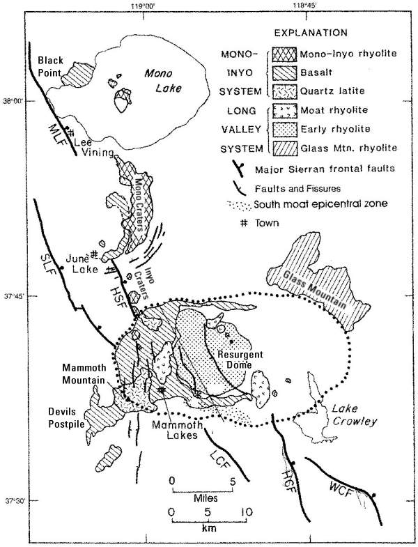
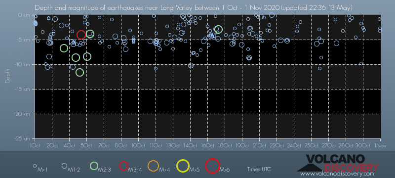
Contact | RSS | EN | DE | EL | ES | FR | IT | RU

Past earthquakes near Long Valley volcano: October 2020 - list, stats and map

Updated: Apr 23, 2024 14:52 GMT -
During October 2020, Long Valley volcano has had 202 quakes of magnitudes up to 3.5:
  • 1 quake above magnitude 3
  • 6 quakes between magnitude 2 and 3
  • 195 quakes below magnitude 2 that people normally don't feel.
Strongest: Mag. 3.5 Earthquake 15km SW of Toms Place, CA -
[smaller] [bigger]

Quakes, magnitude and depth over time

Earthquake depth plot
Depth and magnitude of quakes over time
Filter by magnitude:
all
1.0+
2.0+
3.0+
Showing quakes magnitude 0.5 or higher, within up to 30 km (19 mi) distance (204 quakes):
Past earthquakes near Long Valley volcano: October 2020 - list, stats and map
Date and TimeMag
Depth
DistanceLocationDetailsMap
Oct 31, 2020 04:08 pm (Los Angeles)
0.7

3.2 km
6.3 km (3.9 mi) to the SW 3.7 miles E of Mammoth Lakes, California
Info
Oct 31, 2020 03:57 pm (Los Angeles)
0.4

2.7 km
6.3 km (3.9 mi) to the SW 3.8 miles E of Mammoth Lakes, California
Info
Oct 31, 2020 03:01 pm (Los Angeles)
0.9

0.8 km
16 km (9.8 mi) to the SW 3.3 miles WSW of Mammoth Lakes, California
Info
Friday, October 30, 2020 GMT (4 quakes)
Oct 30, 2020 06:13 am (Los Angeles)
0.8

3 km
19 km (12 mi) to the S 9.8 miles SSE of Mammoth Lakes, California
Info
Oct 30, 2020 03:25 am (Los Angeles)
0.7

2.6 km
23 km (14 mi) to the S 12 miles SSE of Mammoth Lakes, California
Info
Oct 29, 2020 11:33 pm (Los Angeles)
0.7

9.8 km
20 km (12 mi) to the S 10.2 miles SSE of Mammoth Lakes, California
Info
Oct 29, 2020 11:07 pm (Los Angeles)
0.9

1.7 km
12 km (7.6 mi) to the S 4.5 miles SE of Mammoth Lakes, California
Info
Thursday, October 29, 2020 GMT (4 quakes)
Oct 29, 2020 11:58 am (Los Angeles)
0.6

4.5 km
23 km (14 mi) to the S 12 miles SSE of Mammoth Lakes, California
Info
Oct 29, 2020 04:39 am (Los Angeles)
0.1

0.6 km
15 km (9.1 mi) to the SW 4km W of Mammoth Lakes, CA
Info
Oct 28, 2020 11:05 pm (Los Angeles)
0.2

1 km
16 km (9.8 mi) to the SW 5km W of Mammoth Lakes, CA, USA
Info
Oct 28, 2020 09:26 pm (Los Angeles)
0.3

0.1 km
14 km (8.7 mi) to the W 4km NW of Mammoth Lakes, CA, USA
Info
Show more
About these data
Estimated combined seismic energy released: 1.3 x 10¹⁰ joules (3.67 megawatt hours, equivalent to 3.16 tons of TNT) | about seismic energy

Earthquake Catalog - Look up past earthquakes

Look up past earthquakes in this area by date or date range:
or
Look up quakes!
Felt a quake? Report it!
Show quakes near me!

Earthquake statistics

Number of earthquakes over time

during October 2020
in 2020
Number of earthquakes over time: during October 2020
Number of earthquakes over time: in 2020

Magnitude and seismic energy over time

during October 2020
in 2020
Magnitude and seismic energy over time: during October 2020
Magnitude and seismic energy over time: in 2020

Magnitude and energy distribution

during October 2020
in 2020
Magnitude and energy distribution: during October 2020
Magnitude and energy distribution: in 2020

Embed or share standalone map

You can use the standalone version of our interactive earthquake map or embed it on your website:
Fri, 19 Jul 2013, 02:12

Long Valley volcano (California) activity update

Map of recent quakes at the Long Valley caldera (California)
Normal seismic activity with numerous tiny earthquakes continues to occur at the southern and western parts of the caldera as well as under Mammoth mountain. There are no signs of a possible eruption in a near future. ... Read all
Sun, 31 Mar 2013, 10:53

Long Valley caldera (California): felt magnitude 3.8 earthquake

Location of yesterday's 3.8 earthquake
Some felt earthquakes have occurred recently along the southern boundary of Long Valley Caldera, the latest a 3.8 magnitude quakes yesterday. This is not unusual for the volcanic system and does not mean any volcanic eruption should be expected in a near future. The alert status remains green (normal). ... Read all
Simplified geologic map for Long Valley Caldera and the Mono-Inyo Craters volcanic chain (based on Bailey, 1989) CD, Casa Diablo; HC Hot Cree; HCF Hiloton Creek Fault; HSF, Hartley Springs Fault; LCF, Laurel Creek Fault; MLF, Mono Lake Fault; SLF, Silver Lake Fault; WCF, Wheeler Crest Fault. (source: USGS)
Try our free app!
Volcanoes & Earthquakes - new app for Android
Android | iOS version

More on VolcanoDiscovery

Why is there advertising on this site?

Support us - Help us upgrade our services!

We truly love working to bring you the latest volcano and earthquake data from around the world. Maintaining our website and our free apps does require, however, considerable time and resources.
We need financing to increase hard- and software capacity as well as support our editor team. We're aiming to achieve uninterrupted service wherever an earthquake or volcano eruption unfolds, and your donations can make it happen! Every donation will be highly appreciated. If you find the information useful and would like to support our team in integrating further features, write great content, and in upgrading our soft- and hardware, please make a donation (PayPal or Online credit card payment).

Planned features:Thanks to your past donations, these features have been added recently:
Download and Upgrade the Volcanoes & Earthquakes app to get one of the fastest seismic and volcano alerts online:
Android | IOS
Thank you!
Sources: VolcanoDiscovery / VolcanoAdventures and other sources as noted.
Use of material: Most text and images on our websites are owned by us. Re-use is generally not permitted without authorization. Contact us for licensing rights.
Volcanoes & Earthquakes
VolcanoDiscovery Home
Volcanoes | Earthquakes | Photos | Volcano News | App
Adventure & Study Travel
Tours to Volcanoes and Volcanic Areas: walking tours, photo tours, study tours
Tours & Dates | FAQ | About us
Get our newsletter!
Company info
Contact | Legal info | Terms & conditions
Follow us
Follow us on facebook Follow us on Instagram Follow us on Twitter Visit our Youtube channel
EN | DE | EL | ES | FR | IT | RU
VolcanoDiscovery GmbH, Germany, Reg. nr.: HRB 103744, EU Tax Id: DE 297 465 123 owned and created by
Dr. Tom Pfeiffer, volcanologist, volcano photographer, tour organizer member of
IAVCEI
IAVCEI
Vulkanologische Gesellschaft
Volcanological Society
Ecotourism Greece
Ecotourism Greece
RUV insurance
Insured by R+V
VolcanoDiscovery © 2004- All Rights Reserved | Privacy - Cookie Settings