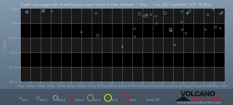
Contact | RSS | EN | DE | EL | ES | FR | IT | RU

Past earthquakes near Mount Rainier volcano: May 2021 - list, stats and map

Updated: Apr 20, 2024 14:17 GMT -
There were 38 small quakes between magnitudes 1.0 and 1.9 near Mount Rainier volcano during May 2021. Look up all recent and past quakes!
Strongest: Mag. 1.9 Earthquake 8 Km NE of Ashford, Washington -
[smaller] [bigger]

Quakes, magnitude and depth over time

Earthquake depth plot
Depth and magnitude of quakes over time
Filter by magnitude:
all
1.0+
Showing quakes magnitude 0.5 or higher, within up to 30 km (19 mi) distance (39 quakes):
Past earthquakes near Mount Rainier volcano: May 2021 - list, stats and map
Date and TimeMag
Depth
DistanceLocationDetailsMap
May 31, 2021 04:41 pm (Universal Time)
0.2

1.1 km
2.1 km (1.3 mi) to the N 24 km ENE of Ashford, Washington
Info
May 31, 2021 07:11 am (Los Angeles)
0.1

1.5 km
4.5 km (2.8 mi) to the N 24 Km NE of Ashford, Washington
Info
May 31, 2021 09:36 am (Universal Time)
0.8

6.6 km
15 km (9.4 mi) to the W 9 km NE of Ashford, Washington
Info
May 31, 2021 12:42 am (Los Angeles)
0.6

1.7 km
5.6 km (3.5 mi) to the E 26 Km N of Packwood, Washington
Info
Sunday, May 30, 2021 GMT (2 quakes)
May 30, 2021 09:04 am (Los Angeles)
0.5

6.3 km
21 km (13 mi) to the SE 15 Km NNE of Packwood, Washington
Info
May 30, 2021 06:01 am (Universal Time)
0.7

0.2 km
4.2 km (2.6 mi) to the N Washington
Info
Saturday, May 29, 2021 GMT (2 quakes)
May 29, 2021 11:02 am (Universal Time)
0.5

2 km
4.3 km (2.7 mi) to the N 24 km NE of Ashford, Washington
Info
May 29, 2021 03:23 am (Universal Time)
0.7

7.1 km
14 km (8.7 mi) to the W 9 km NE of Ashford, Washington
Info
Wednesday, May 26, 2021 GMT (4 quakes)
May 26, 2021 09:53 am (Los Angeles)
1.6

0.7 km
0.8 km (0.5 mi) to the S 22 km ENE of Ashford, Washington
Info
May 26, 2021 09:23 am (Universal Time)
0.1

1.6 km
0.6 km (0.4 mi) to the S 23 km ENE of Ashford, Washington
Info
May 26, 2021 08:52 am (Universal Time)
0.0

1.4 km
0.6 km (0.4 mi) to the NE 23 km ENE of Ashford, Washington
Info
Show more
About these data
Estimated combined seismic energy released: 1.3 x 10⁸ joules (35.6 kilowatt hours) | about seismic energy

Earthquake Catalog - Look up past earthquakes

Look up past earthquakes in this area by date or date range:
or
Look up quakes!
Felt a quake? Report it!
Show quakes near me!

Earthquake statistics

Number of earthquakes over time

during May 2021
in 2021
Number of earthquakes over time: during May 2021
Number of earthquakes over time: in 2021

Magnitude and seismic energy over time

during May 2021
in 2021
Magnitude and seismic energy over time: during May 2021
Magnitude and seismic energy over time: in 2021

Magnitude and energy distribution

during May 2021
in 2021
Magnitude and energy distribution: during May 2021
Magnitude and energy distribution: in 2021

Embed or share standalone map

You can use the standalone version of our interactive earthquake map or embed it on your website:
Fri, 14 Sep 2012, 23:18

Mount Rainier volcano (Washington, USA) activity update: M 2.4 shallow earthquake beneath the north rim of East Crater on 13 Sep

An M 2.4 earthquake occurred beneath the summit of Mount Rainier at 08:45 PDT, September 13, and was followed by a dozen or so aftershocks over the next ~20 minutes. Read all
Try our free app!
Volcanoes & Earthquakes - new app for Android
Android | iOS version

More on VolcanoDiscovery

Why is there advertising on this site?

Support us - Help us upgrade our services!

We truly love working to bring you the latest volcano and earthquake data from around the world. Maintaining our website and our free apps does require, however, considerable time and resources.
We need financing to increase hard- and software capacity as well as support our editor team. We're aiming to achieve uninterrupted service wherever an earthquake or volcano eruption unfolds, and your donations can make it happen! Every donation will be highly appreciated. If you find the information useful and would like to support our team in integrating further features, write great content, and in upgrading our soft- and hardware, please make a donation (PayPal or Online credit card payment).

Planned features:Thanks to your past donations, these features have been added recently:
Download and Upgrade the Volcanoes & Earthquakes app to get one of the fastest seismic and volcano alerts online:
Android | IOS
Thank you!
Sources: VolcanoDiscovery / VolcanoAdventures and other sources as noted.
Use of material: Most text and images on our websites are owned by us. Re-use is generally not permitted without authorization. Contact us for licensing rights.
Volcanoes & Earthquakes
VolcanoDiscovery Home
Volcanoes | Earthquakes | Photos | Volcano News | App
Adventure & Study Travel
Tours to Volcanoes and Volcanic Areas: walking tours, photo tours, study tours
Tours & Dates | FAQ | About us
Get our newsletter!
Company info
Contact | Legal info | Terms & conditions
Follow us
Follow us on facebook Follow us on Instagram Follow us on Twitter Visit our Youtube channel
EN | DE | EL | ES | FR | IT | RU
VolcanoDiscovery GmbH, Germany, Reg. nr.: HRB 103744, EU Tax Id: DE 297 465 123 owned and created by
Dr. Tom Pfeiffer, volcanologist, volcano photographer, tour organizer member of
IAVCEI
IAVCEI
Vulkanologische Gesellschaft
Volcanological Society
Ecotourism Greece
Ecotourism Greece
RUV insurance
Insured by R+V
VolcanoDiscovery © 2004- All Rights Reserved | Privacy - Cookie Settings