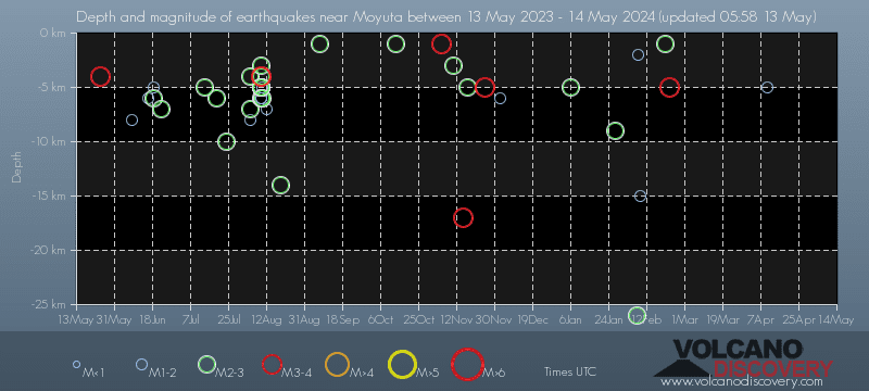
Contact | RSS | EN | DE | EL | ES | FR | IT | RU
1 quake Mag. 1+
0 quakes Mag. 2+
Number of quakes vs long-term average, past 7 days
Earthquake activity below average

Latest quakes near Moyuta volcano since 2024 - list, stats and map

Updated: Apr 20, 2024 04:56 GMT -
Find all latest earthquakes near Moyuta volcano in our list below, updated every minute! Events are often reported within minutes. If you just felt a quake near Moyuta volcano, find out which quakes are happening right now!
There was one earthquake of magnitude 1.7 near Moyuta volcano in the past 7 days.
Since 2024, Moyuta volcano has had 16 quakes of magnitudes up to 4.5:
  • 1 quake above magnitude 4
  • 3 quakes between magnitude 3 and 4
  • 8 quakes between magnitude 2 and 3
  • 4 quakes below magnitude 2 that people normally don't feel.
Number of quakes per year
Read more
[smaller] [bigger]

Quakes, magnitude and depth over time

Past 7 days
14 days
30 days
1 year
Earthquake depth plot
Depth and magnitude of quakes over time
Earthquake depth plot
Depth and magnitude of quakes over time
Earthquake depth plot
Depth and magnitude of quakes over time
Earthquake depth plot
Depth and magnitude of quakes over time
Filter by magnitude:
all
3.0+
4.0+
Check for new quakes now!
in sec
Pause automatic refreshing
Showing all recent or significant quakes since 2024, magnitude 0 or higher, within up to 30 km (19 mi) distance (16 quakes):
Latest quakes near Moyuta volcano since 2024 - list, stats and map
Date and TimeMag
Depth
DistanceLocationDetailsMap
Apr 19, 12:22 am (El Salvador)
1.7

95 km
16 km (10.2 mi) to the E 14 km northwest of Ahuachapan, Ahuachapan, El Salvador
Info
Wednesday, April 10, 2024 GMT (1 quake)
Apr 10, 02:56 am (Guatemala)
1.9

5 km
29 km (18 mi) to the NW 17 Km al sur de Cuilapa, Guatemala
Info
Wednesday, April 3, 2024 GMT (1 quake)
Apr 3, 05:06 pm (Guatemala)
4.5

132 km
13 km (8.4 mi) to the W 3 km NNW of Pasaco, Guatemala
Info
Friday, February 23, 2024 GMT (1 quake)
Feb 23, 05:18 am (Guatemala)
3.0

5 km
28 km (17 mi) to the S 10 Km Al Norte De Las Brisas, Guatemala
Info
Wednesday, February 21, 2024 GMT (1 quake)
Feb 20, 11:12 pm (El Salvador)
2.1

1 km
29 km (18 mi) to the SE 9 Km Al Suroeste De Ahuachapan, El Salvador
Info
Sunday, February 18, 2024 GMT (1 quake)
Feb 18, 03:49 am (Guatemala)
2.0

32 km
15 km (9.6 mi) to the E Guatemala: 18 Km Al Noroeste De Ahuachapan, El Salvador
Info
Wednesday, February 14, 2024 GMT (1 quake)
Feb 14, 04:28 pm (Guatemala)
2.1

66 km
21 km (13 mi) to the NW 14 Km Al Sureste De Cuilapa, Guatemala
Info
Friday, February 9, 2024 GMT (1 quake)
Feb 8, 10:24 pm (Guatemala)
1.9

15 km
27 km (17 mi) to the N 13 Km Al Norte De Cuilapa, Guatemala
Info
Thursday, February 8, 2024 GMT (1 quake)
Feb 7, 07:44 pm (El Salvador)
1.8

2 km
30 km (18 mi) to the SE 9 Km Al Suroeste De Ahuachapan, El Salvador
Info
Wednesday, February 7, 2024 GMT (1 quake)
Feb 7, 05:05 am (El Salvador)
2.1

26 km
29 km (18 mi) to the E 5 Km Al Norte De Ahuachapan, El Salvador 1 report
Info
Friday, February 2, 2024 GMT (1 quake)
Feb 2, 03:51 am (Guatemala)
2.5

64 km
3.1 km (1.9 mi) to the SE Guatemala: 27 Km Al Noroeste De Ahuachapan, El Salvador
Info
Show more
About these data
Estimated combined seismic energy released: 3.7 x 10¹¹ joules (102 megawatt hours, equivalent to 88 tons of TNT) | about seismic energy

Earthquake Catalog - Look up past earthquakes

Look up past earthquakes in this area by date or date range:
or
Look up quakes!
Felt a quake? Report it!
Show quakes near me!

Earthquake statistics

Number of quakes per year

Note:
The apparent increase in the number of quakes is not because global seismic activity has increased, but because the number of seismic networks around the world and their sensitivity to detect smaller quakes has been constantly increasing.
This is most evident if one looks at the number of smaller earthquakes (below magnitude 5). For larger quakes (magnitude 5 or more), the effect disappears after around the 1990s. Since then, the global coverage of earthquake of larger quakes has been nearly complete.

Average number of earthquakes

Based on data from the past 14 years and our earthquake archive back to 1900, there are about 111 quakes on average per year near Moyuta volcano:
  • Mag. 6 or higher: 0.02 quakes per year (or 1 quake every 62.5 years)
  • Mag. 5 or higher: 0.51 quakes per year (or 1 quake every 2 years)
  • Mag. 4 or higher: 3.1 quakes per year
  • Mag. 3 or higher: 16.7 quakes per year
  • Mag. 2 or higher: 79 quakes per year (or 6.6 quakes per month)
  • Mag. 1 or higher: 112 quakes per year (or 9.3 quakes per month)

Number of earthquakes over time

Past 90 days
30 days
7 days
24 hours
2023
2024 so far
Number of earthquakes over time: Past 90 days
Number of earthquakes over time: 30 days
Number of earthquakes over time: 7 days
Number of earthquakes over time: 24 hours
Number of earthquakes over time: 2023
Number of earthquakes over time: 2024 so far

Magnitude and seismic energy over time

Past 90 days
30 days
7 days
24 hours
2023
2024 so far
Magnitude and seismic energy over time: Past 90 days
Magnitude and seismic energy over time: 30 days
Magnitude and seismic energy over time: 7 days
Magnitude and seismic energy over time: 24 hours
Magnitude and seismic energy over time: 2023
Magnitude and seismic energy over time: 2024 so far

Magnitude and energy distribution

Past 90 days
30 days
7 days
24 hours
2023
2024 so far
Magnitude and energy distribution: Past 90 days
Magnitude and energy distribution: 30 days
Magnitude and energy distribution: 7 days
Magnitude and energy distribution: 24 hours
Magnitude and energy distribution: 2023
Magnitude and energy distribution: 2024 so far

Embed or share standalone map

You can use the standalone version of our interactive earthquake map or embed it on your website:

No news in this list.

Try our free app!
Volcanoes & Earthquakes - new app for Android
Android | iOS version

More on VolcanoDiscovery

Why is there advertising on this site?

Support us - Help us upgrade our services!

We truly love working to bring you the latest volcano and earthquake data from around the world. Maintaining our website and our free apps does require, however, considerable time and resources.
We need financing to increase hard- and software capacity as well as support our editor team. We're aiming to achieve uninterrupted service wherever an earthquake or volcano eruption unfolds, and your donations can make it happen! Every donation will be highly appreciated. If you find the information useful and would like to support our team in integrating further features, write great content, and in upgrading our soft- and hardware, please make a donation (PayPal or Online credit card payment).

Planned features:Thanks to your past donations, these features have been added recently:
Download and Upgrade the Volcanoes & Earthquakes app to get one of the fastest seismic and volcano alerts online:
Android | IOS
Thank you!
Sources: VolcanoDiscovery / VolcanoAdventures and other sources as noted.
Use of material: Most text and images on our websites are owned by us. Re-use is generally not permitted without authorization. Contact us for licensing rights.
Volcanoes & Earthquakes
VolcanoDiscovery Home
Volcanoes | Earthquakes | Photos | Volcano News | App
Adventure & Study Travel
Tours to Volcanoes and Volcanic Areas: walking tours, photo tours, study tours
Tours & Dates | FAQ | About us
Get our newsletter!
Company info
Contact | Legal info | Terms & conditions
Follow us
Follow us on facebook Follow us on Instagram Follow us on Twitter Visit our Youtube channel
EN | DE | EL | ES | FR | IT | RU
VolcanoDiscovery GmbH, Germany, Reg. nr.: HRB 103744, EU Tax Id: DE 297 465 123 owned and created by
Dr. Tom Pfeiffer, volcanologist, volcano photographer, tour organizer member of
IAVCEI
IAVCEI
Vulkanologische Gesellschaft
Volcanological Society
Ecotourism Greece
Ecotourism Greece
RUV insurance
Insured by R+V
VolcanoDiscovery © 2004- All Rights Reserved | Privacy - Cookie Settings