Contact | RSS | EN | DE | EL | ES | FR | IT | RU

Nemrut Dagi Volcano

Updated: Apr 18, 2024 12:21 GMT -
caldera 2948 m
Turkey, 38.62°N / 42.26°E
Current status: normal or dormant (1 out of 5)
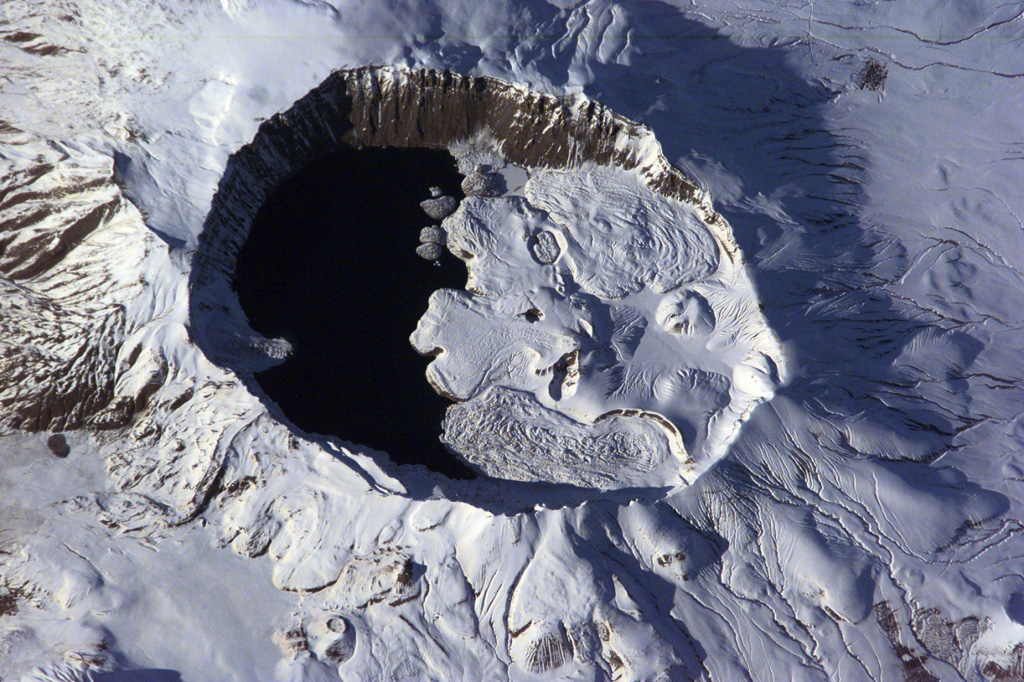
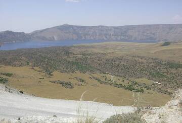
The summit of Nemrut Dagi is truncated by a 5 x 9 km caldera near Lake Van in eastern Turkey. A lake that partially fills the western side of the caldera is constrained by post-caldera eruptions that produced glassy obsidian lava flows from domes on the eastern caldera floor. A series of scoria cones and lava domes were erupted along N-S-trending fissures on the northern flank. Ash layers in Lake Van document numerous Holocene eruptions from Nemrut Dagi. (Image: NASA International Space Station image ISS001-E-6354, 2001, http://eol.jsc.nasa.gov/).

Nemrut Dağ (or Nemrut Dagi) volcano is the westernmost of a group of volcanoes near Lake Van in eastern Anatolia, and the only one that has erupted in historical time. It contains a 9 x 5 km caldera partially filled on its western side by a caldera lake.

[smaller] [larger]
Typical eruption style: explosive
Nemrut Dagi volcano eruptions: 1881 AD
1441 AD

Latest nearby earthquakes

No recent earthquakes
TimeMag. / DepthDistance / Location

Background

The diameter of the caldera is about 9 x 5 km and it is half filled by a crater lake. Volcanic activity after the caldera formation has produced rhyolithic & basaltic lava flows and domes at the caldera rim and on its floor.
Pyroclastic flows and the emission of glassy obsidian lava flows accompanied construction of lava domes within the caldera; later activity formed a series of cinder cones and lava domes erupted along N-S-trending fissures on the northern flank. The most recent activity has been concentrated along a NNW-trending fissure cutting the eastern caldera floor and extending beyond the north caldera rim; nearly two dozen cinder cones and lava domes were constructed on the caldera floor. Ash layers in Lake Van document numerous Holocene eruptions, and an historical eruption in 1441 AD from a north-flank fissure involved compositionally bimodal lava flows.

Nemrut Dagi Volcano Photos
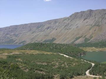
Latest satellite images

NemrutDagi satellite image sat1NemrutDagi satellite image sat2
News

No news in this list.

On this page:

Try our free app!
Volcanoes & Earthquakes - new app for Android
Android | iOS version

More on VolcanoDiscovery

Why is there advertising on this site?

Support us - Help us upgrade our services!

We truly love working to bring you the latest volcano and earthquake data from around the world. Maintaining our website and our free apps does require, however, considerable time and resources.
We need financing to increase hard- and software capacity as well as support our editor team. We're aiming to achieve uninterrupted service wherever an earthquake or volcano eruption unfolds, and your donations can make it happen! Every donation will be highly appreciated. If you find the information useful and would like to support our team in integrating further features, write great content, and in upgrading our soft- and hardware, please make a donation (PayPal or Online credit card payment).

Planned features:Thanks to your past donations, these features have been added recently:
Download and Upgrade the Volcanoes & Earthquakes app to get one of the fastest seismic and volcano alerts online:
Android | IOS
Thank you!
Sources: VolcanoDiscovery / VolcanoAdventures and other sources as noted.
Use of material: Most text and images on our websites are owned by us. Re-use is generally not permitted without authorization. Contact us for licensing rights.
Volcanoes & Earthquakes
VolcanoDiscovery Home
Volcanoes | Earthquakes | Photos | Volcano News | App
Adventure & Study Travel
Tours to Volcanoes and Volcanic Areas: walking tours, photo tours, study tours
Tours & Dates | FAQ | About us
Get our newsletter!
Company info
Contact | Legal info | Terms & conditions
Follow us
Follow us on facebook Follow us on Instagram Follow us on Twitter Visit our Youtube channel
EN | DE | EL | ES | FR | IT | RU
VolcanoDiscovery GmbH, Germany, Reg. nr.: HRB 103744, EU Tax Id: DE 297 465 123 owned and created by
Dr. Tom Pfeiffer, volcanologist, volcano photographer, tour organizer member of
IAVCEI
IAVCEI
Vulkanologische Gesellschaft
Volcanological Society
Ecotourism Greece
Ecotourism Greece
RUV insurance
Insured by R+V
VolcanoDiscovery © 2004- All Rights Reserved | Privacy - Cookie Settings