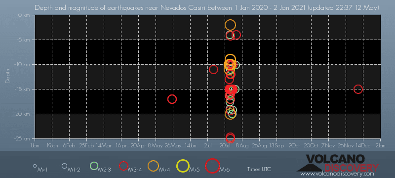
Contact | RSS | EN | DE | EL | ES | FR | IT | RU

Past earthquakes near Nevados Casiri volcano: 2020 - list, stats and map

Updated: Apr 19, 2024 23:29 GMT -
In 2020, Nevados Casiri volcano has had 88 quakes of magnitudes above 2 and up to 4.9:
  • 14 quakes above magnitude 4
  • 43 quakes between magnitude 3 and 4
  • 31 quakes between magnitude 2 and 3
Strongest: Mag. 4.9 Earthquake 15 km E of Tarata, Peru -
[smaller] [bigger]

Quakes, magnitude and depth over time

Earthquake depth plot
Depth and magnitude of quakes over time
Filter by magnitude:
all
4.0+
Showing quakes magnitude 0.5 or higher, within up to 30 km (19 mi) distance (89 quakes):
Past earthquakes near Nevados Casiri volcano: 2020 - list, stats and map
Date and TimeMag
Depth
DistanceLocationDetailsMap
Dec 24, 2020 06:59 pm (Lima)
4.7

124 km
11 km (7.1 mi) to the NW Peru-Bolivia Border Region
Info
Wednesday, December 9, 2020 GMT (1 quake)
Dec 9, 2020 08:45 am (Lima)
3.8

15 km
24 km (15 mi) to the NW Provincia de Tarata, 87 km north of Tacna, Tacna, Peru
Info
Tuesday, December 1, 2020 GMT (2 quakes)
Dec 1, 2020 03:41 pm (Lima)
3.0

156 km
21 km (13 mi) to the SE 3.1 km east of Alto Peru, Tacna, Peru
Info
Dec 1, 2020 01:27 pm (Lima)
3.0

160 km
21 km (13 mi) to the SE 4.2 km east of Alto Peru, Tacna, Peru
Info
Friday, October 16, 2020 GMT (1 quake)
Oct 16, 2020 07:44 am (Lima)
3.8

158 km
18 km (11 mi) to the SW 59 km northeast of Tacna, Peru
Info
Thursday, August 27, 2020 GMT (1 quake)
Aug 27, 2020 04:30 am (Lima)
3.0

163 km
21 km (13 mi) to the N El Collao Province, Puno, 97 km northeast of Tacna, Peru
Info
Sunday, August 2, 2020 GMT (1 quake)
Aug 1, 2020 07:12 pm (Lima)
3.1

4 km
25 km (16 mi) to the NW Southern Peru
Info
Saturday, August 1, 2020 GMT (2 quakes)
Jul 31, 2020 10:30 pm (Lima)
2.5

10.1 km
11 km (7 mi) to the NW 46 km al NO de Visviri (Peru) 1 report
Info
Jul 31, 2020 08:33 pm (Lima)
2.6

15 km
20 km (13 mi) to the N Southern Peru
Info
Wednesday, July 29, 2020 GMT (6 quakes)
Jul 28, 2020 11:07 pm (Lima)
2.8

15 km
19 km (12 mi) to the N 48 km al NO de Visviri (Peru)
Info
Jul 28, 2020 10:52 pm (Lima)
3.8

10 km
8.4 km (5.2 mi) to the N 84 km northeast of Tacna, Peru
Info
Show more
About these data
Estimated combined seismic energy released: 5.5 x 10¹² joules (1.52 gigawatt hours, equivalent to 1310 tons of TNT) | about seismic energy

Earthquake Catalog - Look up past earthquakes

Look up past earthquakes in this area by date or date range:
or
Look up quakes!
Felt a quake? Report it!
Show quakes near me!

Earthquake statistics

Number of earthquakes over time

in 2020
Number of earthquakes over time: in 2020

Magnitude and seismic energy over time

in 2020
Magnitude and seismic energy over time: in 2020

Magnitude and energy distribution

in 2020
Magnitude and energy distribution: in 2020

Embed or share standalone map

You can use the standalone version of our interactive earthquake map or embed it on your website:

No news in this list.

Try our free app!
Volcanoes & Earthquakes - new app for Android
Android | iOS version

More on VolcanoDiscovery

Why is there advertising on this site?

Support us - Help us upgrade our services!

We truly love working to bring you the latest volcano and earthquake data from around the world. Maintaining our website and our free apps does require, however, considerable time and resources.
We need financing to increase hard- and software capacity as well as support our editor team. We're aiming to achieve uninterrupted service wherever an earthquake or volcano eruption unfolds, and your donations can make it happen! Every donation will be highly appreciated. If you find the information useful and would like to support our team in integrating further features, write great content, and in upgrading our soft- and hardware, please make a donation (PayPal or Online credit card payment).

Planned features:Thanks to your past donations, these features have been added recently:
Download and Upgrade the Volcanoes & Earthquakes app to get one of the fastest seismic and volcano alerts online:
Android | IOS
Thank you!
Sources: VolcanoDiscovery / VolcanoAdventures and other sources as noted.
Use of material: Most text and images on our websites are owned by us. Re-use is generally not permitted without authorization. Contact us for licensing rights.
Volcanoes & Earthquakes
VolcanoDiscovery Home
Volcanoes | Earthquakes | Photos | Volcano News | App
Adventure & Study Travel
Tours to Volcanoes and Volcanic Areas: walking tours, photo tours, study tours
Tours & Dates | FAQ | About us
Get our newsletter!
Company info
Contact | Legal info | Terms & conditions
Follow us
Follow us on facebook Follow us on Instagram Follow us on Twitter Visit our Youtube channel
EN | DE | EL | ES | FR | IT | RU
VolcanoDiscovery GmbH, Germany, Reg. nr.: HRB 103744, EU Tax Id: DE 297 465 123 owned and created by
Dr. Tom Pfeiffer, volcanologist, volcano photographer, tour organizer member of
IAVCEI
IAVCEI
Vulkanologische Gesellschaft
Volcanological Society
Ecotourism Greece
Ecotourism Greece
RUV insurance
Insured by R+V
VolcanoDiscovery © 2004- All Rights Reserved | Privacy - Cookie Settings