Pacaya Volcano
Updated: Apr 20, 2024 14:07 GMT -
Complex volcano 2552 m (8,373 ft)
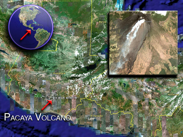
Guatemala, 14.38°N / -90.6°W
Current status: normal or dormant (1 out of 5)
Guatemala, 14.38°N / -90.6°W
Current status: normal or dormant (1 out of 5)
Last update: 17 Apr 2022 (Smithsonian / USGS Weekly Volcanic Activity Report)
Pacaya volcano near Guatemala City is one of Guatemala's most active volcanoes, and its frequent eruptions are often visible from Guatemala City. Typical activity in recent years includes strombolian activity, lava flow emission and intermittend violent phases of lava fountaining.
[smaller] [larger]
Pacaya volcano eruptions: 1360, 1565, 1623(?), 1651, 1655, 1664, 1668, 1671, 1674, 1677(?), 1678, 1690, 1693, 1699, 1717(?), 1760(?), 1775, 1805, 1830(?), 1846, 1885, 1961, 1965, 1970, 1972, 1973, 1976, 1977, 1978, 1980 - May 1998 (intense period of summit activity), 1999-2003, 2004-2010, 2012, 2013, 2014
Latest nearby earthquakes
| Time | Mag. / Depth | Distance / Location | |||
| Apr 20, 04:56 am (Guatemala) | 2.4 7 km | 28 km (18 mi) to the N | Info | ||
| Thursday, April 18, 2024 GMT (1 quake) | |||||
| Apr 18, 06:10 am (GMT -6) | 0.0 21 km | 29 km (18 mi) to the E | Info | ||
| Tuesday, April 16, 2024 GMT (1 quake) | |||||
| Apr 15, 07:30 pm (Guatemala) | 2.7 22 km | 24 km (15 mi) to the W | Info | ||
| Wednesday, April 10, 2024 GMT (1 quake) | |||||
| Apr 9, 07:10 pm (GMT -6) | ? n/a | 29 km (18 mi) to the NE | Info | ||
| Thursday, April 4, 2024 GMT (1 quake) | |||||
| Apr 4, 03:15 pm (Guatemala) | 2.5 15 km | 29 km (18 mi) to the S | Info | ||
| Monday, April 1, 2024 GMT (1 quake) | |||||
| Apr 1, 04:35 am (Guatemala) | 1.9 6 km | 25 km (16 mi) to the E | Info | ||
| Sunday, March 17, 2024 GMT (2 quakes) | |||||
| Mar 17, 01:06 am (Guatemala) | 2.3 2 km | 21 km (13 mi) to the NE | Info | ||
| Mar 17, 01:05 am (Guatemala) | 2.1 10 km | 19 km (12 mi) to the NE | Info | ||
| Friday, March 15, 2024 GMT (1 quake) | |||||
| Mar 15, 02:46 am (Guatemala) | 2.4 204 km | 11 km (7.1 mi) to the N | Info | ||
| Saturday, February 3, 2024 GMT (2 quakes) | |||||
| Feb 3, 12:30 pm (Guatemala) | 3.1 199 km | 10.4 km (6.5 mi) to the SE | Info | ||
| Feb 3, 12:14 pm (Guatemala) | 2.4 51 km | 29 km (18 mi) to the SE | Info | ||
Background
Pacaya is a complex basaltic volcano constructed just outside the southern topographic rim of the 14 x 16 km Pleistocene Amatitlán caldera. A cluster of dacitic lava domes occupies the southern caldera floor. The post-caldera Pacaya massif includes the Cerro Grande lava dome and a younger volcano to the SW. Collapse of Pacaya volcano about 1100 years ago produced a debris-avalanche deposit that extends 25 km onto the Pacific coastal plain and left an arcuate somma rim inside which the modern Pacaya volcano (MacKenney cone) grew. A subsidiary crater, Cerro Chino, was constructed on the NW somma rim and was last active in the 19th century.During the past several decades, activity at Pacaya has consisted of frequent strombolian eruptions with intermittent lava flow extrusion that has partially filled in the caldera moat and armored the flanks of MacKenney cone, punctuated by occasional larger explosive eruptions that partially destroy the summit of the cone.
Source: GVP
Pacaya Volcano Photos
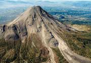
Pacaya volcano with its lava flows seen from Acatenango volcano. (Photo: Tom Pfeiffer)
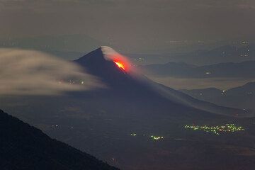
View onto the fast flowing lava (Photo: Tom Pfeiffer)
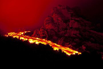
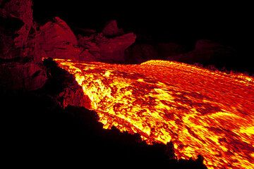
Lava flow at Pacaya volcano (Photo: Tom Pfeiffer)
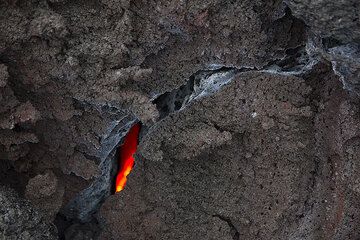
The interior of the cooling lava flow is still glowing hot. (Photo: Tom Pfeiffer)
Latest satellite images

Pacaya Volcano Tours
Guatemala
Guatemala Volcano Special
11-day volcano tour to Pacaya and Fuego, Guatemala
8-12 days - Moderate to Challenging
Price $ 3490
Price $ 3490
no scheduled dates at present