Latest Worldwide >  Guatemala > Suchitepeque > Mazatenango
SEARCH
Latest Quakes | Top 20 | Report a Quake! | Damaging Quakes | By Country/Region | Near Me | Quake Stats | FAQ | News | Volcanoes | Be Safe


SEARCH
| Latest See all | Mag. 3.0 earthquake North Pacific Ocean - Escuintla, Guatemala - |
| Strongest past 30 days | Mag. 4.8 45 km south of Santa Lucia Cotzumalguapa - Escuintla, Guatemala - Apr 14, 2024 - |
Date and Time | Mag Depth | Nearest Volcano | Location | Details | Map |
|---|---|---|---|---|---|
| Apr 24, 08:24 pm (GMT -6) | 3.0 30 km | 93 km (58 mi) to the S | Info | ||
| Wednesday, April 24, 2024 GMT (1 quake) | |||||
| Apr 24, 02:18 am (Guatemala) | 2.4 35 km | 58 km (36 mi) to the E | Info | ||
| Monday, April 22, 2024 GMT (1 quake) | |||||
| Apr 21, 08:12 pm (Guatemala) | 4.1 52 km | 60 km (37 mi) to the S | Info | ||
| Saturday, April 20, 2024 GMT (1 quake) | |||||
| Apr 19, 10:48 pm (Guatemala) | 2.9 23 km | 63 km (39 mi) to the SW | Info | ||
| Friday, April 19, 2024 GMT (1 quake) | |||||
| Apr 18, 08:49 pm (Guatemala) | 2.9 34 km | 68 km (42 mi) to the S | Info | ||
| Thursday, April 18, 2024 GMT (4 quakes) | |||||
| Apr 18, 03:06 pm (Guatemala) | 3.2 1 km | 98 km (61 mi) to the SE | Info | ||
| Apr 18, 03:10 am (Guatemala) | 4.0 99 km | 56 km (35 mi) to the W | Info | ||
| Apr 18, 03:10 am (Guatemala) | 2.8 82 km | 60 km (38 mi) to the W | Info | ||
| Apr 17, 09:00 pm (Guatemala) | 2.6 6 km | 41 km (25 mi) to the NW | Info | ||
| Wednesday, April 17, 2024 GMT (1 quake) | |||||
| Apr 17, 03:09 am (Guatemala) | 3.2 220 km | 86 km (54 mi) to the N | Info | ||
| Tuesday, April 16, 2024 GMT (6 quakes) | |||||
| Apr 16, 01:36 pm (GMT -6) | 0.0 10 km | 56 km (35 mi) to the SE | Info | ||
| or | ||
Look up quakes! | ||
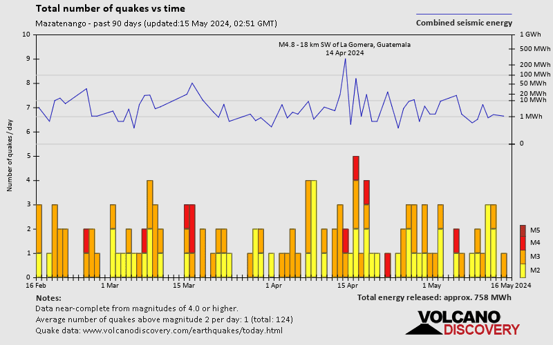
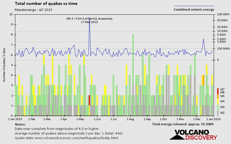
Mazatenango has a very high level of seismic activity. Based on data from the past 14 years and our earthquake archive back to 1900, there are about 258 quakes on average per year in or near Mazatenango, Suchitepeque, Guatemala. Mazatenango has had at least 6 quakes above magnitude 7 since 1900, which suggests that larger earthquakes of this size occur infrequently, probably on average approximately every 20 to 25 years.
The last earthquake in Mazatenango occurred 14 hours ago and had a magnitude of 3.0:
A light magnitude 3.0 earthquake occurred in the North Pacific Ocean near the coast of ![]() Guatemala in the evening of Wednesday, Apr 24, 2024 at 8.24 pm local time (GMT -6). The quake had a very shallow depth of 30 km (19 mi) and was not felt (or at least not reported so).
Guatemala in the evening of Wednesday, Apr 24, 2024 at 8.24 pm local time (GMT -6). The quake had a very shallow depth of 30 km (19 mi) and was not felt (or at least not reported so).
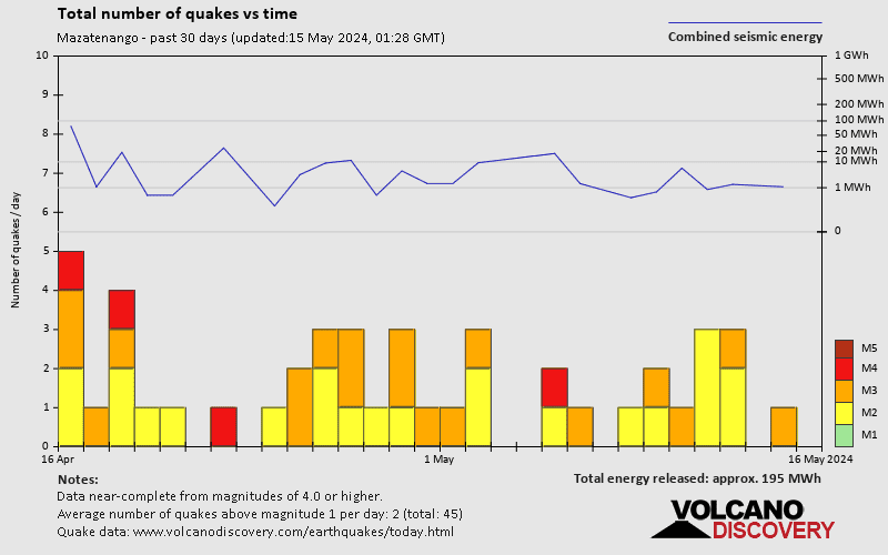
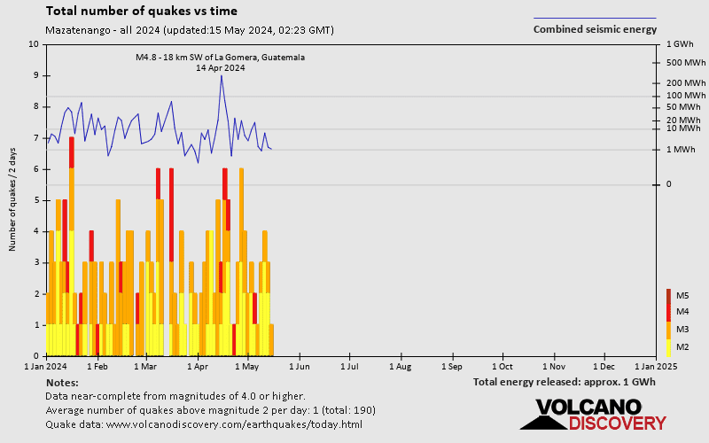
In the past 30 days, Mazatenango has been shaken by 4 quakes of magnitude 4.0 or above, 22 quakes between 3.0 and 4.0, and 18 quakes between 2.0 and 3.0.
The strongest earthquake in Mazatenango in the past 30 days had a magnitude of 4.8 and occurred 11 days ago:
A strong magnitude 4.8 earthquake hit 45 km (28 mi) away from Santa Lucia Cotzumalguapa, Escuintla, ![]() Guatemala, around noon of Sunday, Apr 14, 2024 at 1.14 pm local time (America/Guatemala GMT -6). The quake had a moderate depth of 81 km (50 mi) and was felt widely in the area.
Guatemala, around noon of Sunday, Apr 14, 2024 at 1.14 pm local time (America/Guatemala GMT -6). The quake had a moderate depth of 81 km (50 mi) and was felt widely in the area.
Date and Time | Mag Depth | ###DIST_LABEL### | Location | Details | Map |
|---|