Latest Worldwide >  Mexico > Chiapas > Villaflores
SEARCH
Latest Quakes | Top 20 | Report a Quake! | Damaging Quakes | By Country/Region | Near Me | Quake Stats | FAQ | News | Volcanoes | Be Safe


SEARCH
| Latest See all | Mag. 3.7 earthquake 17 km north of Mapastepec - Chiapas, Mexico - |
| Strongest past 30 days | Mag. 4.3 Mexico: 23 km al SUROESTE de PIJIJIAPAN - CHIS - Apr 6, 2024 - |
Date and Time | Mag Depth | Nearest Volcano | Location | Details | Map |
|---|---|---|---|---|---|
| Apr 22, 04:40 am (Mexico City) | 3.7 124 km | 80 km (50 mi) to the SE | Info | ||
| Sunday, April 21, 2024 GMT (1 quake) | |||||
| Apr 21, 12:26 am (Mexico City) | 3.3 152 km | 96 km (60 mi) to the NW | Info | ||
| Saturday, April 20, 2024 GMT (1 quake) | |||||
| Apr 20, 08:41 am (Mexico City) | 4.2 173 km | 87 km (54 mi) to the NW | Info | ||
| Friday, April 19, 2024 GMT (1 quake) | |||||
| Apr 19, 03:05 am (Mexico City) | 3.8 37 km | 57 km (35 mi) to the SE | Info | ||
| Thursday, April 18, 2024 GMT (1 quake) | |||||
| Apr 18, 04:06 am (Mexico City) | 3.4 162 km | 57 km (35 mi) to the NW | Info | ||
| Sunday, April 14, 2024 GMT (1 quake) | |||||
| Apr 14, 02:08 am (Mexico City) | 4.0 244 km | 39 km (24 mi) to the NE | Info | ||
| Saturday, April 13, 2024 GMT (2 quakes) | |||||
| Apr 13, 12:06 pm (Mexico City) | 3.4 151 km | 52 km (32 mi) to the NW | Info | ||
| Apr 13, 02:30 am (Mexico City) | 3.7 158 km | 69 km (43 mi) to the SE | Info | ||
| Friday, April 12, 2024 GMT (1 quake) | |||||
| Apr 12, 02:38 am (Mexico City) | 3.5 140 km | 87 km (54 mi) to the NW | Info | ||
| Thursday, April 11, 2024 GMT (2 quakes) | |||||
| Apr 11, 08:38 am (Mexico City) | 4.1 212 km | 16 km (10 mi) to the E | Info | ||
| Apr 11, 12:42 am (Mexico City) | 4.0 110 km | 65 km (41 mi) to the W | Info | ||
| or | ||
Look up quakes! | ||
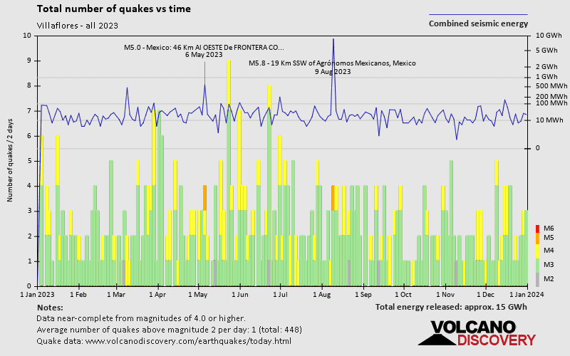
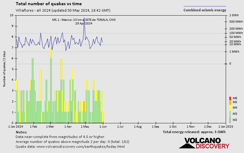
Villaflores has a very high level of seismic activity. Based on data from the past 54 years and our earthquake archive back to 1900, there are about 354 quakes on average per year in or near Villaflores, Chiapas, Mexico. Villaflores has had at least 2 quakes above magnitude 7 since 1900, which suggests that larger earthquakes of this size occur infrequently, probably on average approximately every 60 to 65 years.
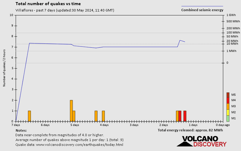
The last earthquake in Villaflores occurred 1 day 4 hours ago and had a magnitude of 3.7:
A moderate magnitude 3.7 earthquake hit 17.5 km (11 mi) away from Mapastepec, Chiapas, ![]() Mexico, in the early morning of Monday, Apr 22, 2024 at 4.40 am local time (America/Mexico City GMT -6). The quake had a moderate depth of 124 km (77 mi) and was not felt (or at least not reported so).
Mexico, in the early morning of Monday, Apr 22, 2024 at 4.40 am local time (America/Mexico City GMT -6). The quake had a moderate depth of 124 km (77 mi) and was not felt (or at least not reported so).
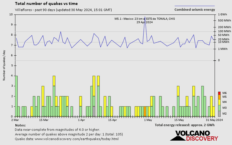
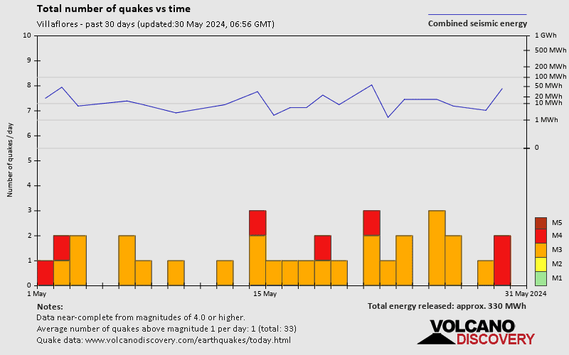
In the past 30 days, Villaflores has been shaken by 9 quakes of magnitude 4.0 or above, 21 quakes between 3.0 and 4.0, and 1 quake of magnitude.
The strongest earthquake in Villaflores in the past 30 days had a magnitude of 4.3 and occurred 2 weeks ago:
A moderate magnitude 4.3 earthquake occurred in the North Pacific Ocean near the coast of Chiapas State, ![]() Mexico, in the early morning of Saturday, Apr 6, 2024 at 4.46 am local time (America/Mexico City GMT -6). The quake had a moderate depth of 94 km (58 mi) and was not felt (or at least not reported so).
Mexico, in the early morning of Saturday, Apr 6, 2024 at 4.46 am local time (America/Mexico City GMT -6). The quake had a moderate depth of 94 km (58 mi) and was not felt (or at least not reported so).
Date and Time | Mag Depth | ###DIST_LABEL### | Location | Details | Map |
|---|