Latest Worldwide >  United States > Nevada > Hawthorne
SEARCH
Latest Quakes | Top 20 | Report a Quake! | Damaging Quakes | By Country/Region | Near Me | Quake Stats | FAQ | News | Volcanoes | Be Safe


SEARCH
| Latest See all | Mag. 2.9 earthquake Esmeralda County - Nevada, United States - |
| Strongest since 2024 | Mag. 3.1 31 Km SSW of Mina - Nevada - Jan 9, 2024 - |
Date and Time | Mag Depth | Nearest Volcano | Location | Details | Map |
|---|---|---|---|---|---|
| Apr 20, 01:37 am (Los Angeles) | 2.9 13 km | 75 km (47 mi) to the SE | Info | ||
| Apr 20, 12:34 am (Los Angeles) | 1.0 3.3 km | 65 km (40 mi) to the SE | Info | ||
| Apr 20, 12:12 am (Los Angeles) | 1.3 1.6 km | 65 km (40 mi) to the SE | Info | ||
| Apr 19, 11:30 pm (Los Angeles) | 1.4 2.1 km | 66 km (41 mi) to the SE | Info | ||
| Apr 19, 08:49 pm (Los Angeles) | 1.4 3.7 km | 65 km (41 mi) to the SE | Info | ||
| Friday, April 19, 2024 GMT (5 quakes) | |||||
| Apr 19, 12:38 pm (Los Angeles) | 1.2 11 km | 77 km (48 mi) to the SE | Info | ||
| Apr 19, 05:07 am (Los Angeles) | 2.4 13 km | 71 km (44 mi) to the SE | Info | ||
| Apr 19, 05:05 am (Los Angeles) | 2.9 13 km | 70 km (44 mi) to the SE | Info | ||
| Apr 18, 07:23 pm (Los Angeles) | 2.0 2.9 km | 72 km (45 mi) to the SE | Info | ||
| Apr 18, 07:23 pm (Los Angeles) | 1.9 4.3 km | 66 km (41 mi) to the SE | Info | ||
| Saturday, April 13, 2024 GMT (1 quake) | |||||
| Apr 13, 02:36 am (Los Angeles) | 1.4 2.6 km | 73 km (46 mi) to the SE | Info | ||
| or | ||
Look up quakes! | ||
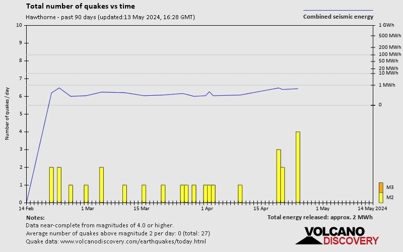
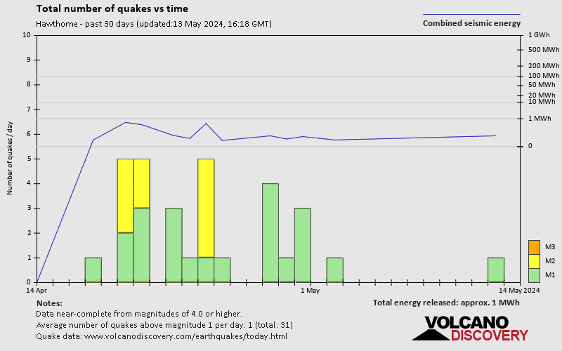
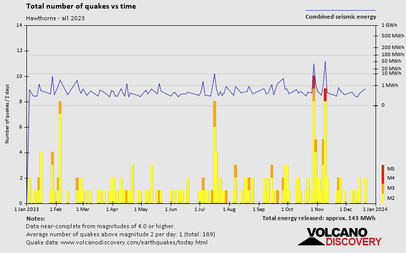
Hawthorne has a high level of seismic activity. Based on data from the past 54 years and our earthquake archive back to 1900, there are about 7,300 quakes on average per year in or near Hawthorne, Nevada, USA. Hawthorne has had at least 8 quakes above magnitude 6 since 1900, which suggests that larger earthquakes of this size occur infrequently, probably on average approximately every 15 to 20 years.
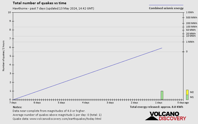
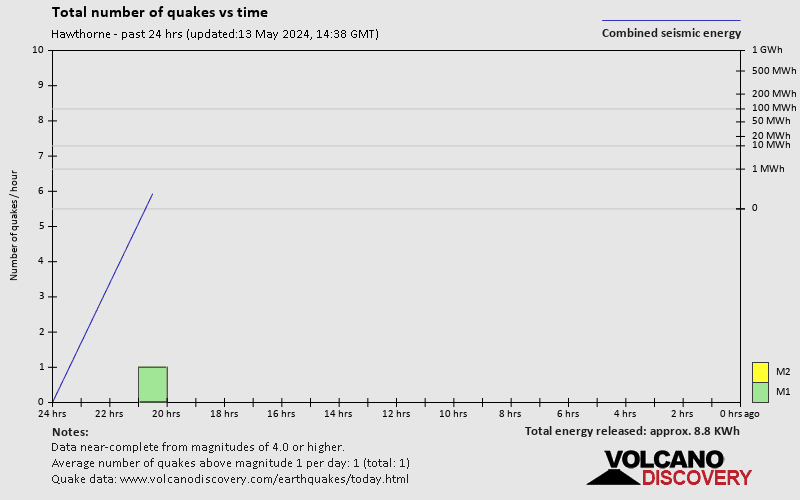
The last earthquake in Hawthorne occurred 5 hours ago and had a magnitude of 2.9:
A light magnitude 2.9 earthquake hit 58 km (36 mi) away from Tonopah, Nevada, ![]() United States, in the early morning of Saturday, Apr 20, 2024 at 1.37 am local time (America/Los Angeles GMT -7). The quake had a very shallow depth of 12.5 km (8 mi) and was not felt (or at least not reported so).
United States, in the early morning of Saturday, Apr 20, 2024 at 1.37 am local time (America/Los Angeles GMT -7). The quake had a very shallow depth of 12.5 km (8 mi) and was not felt (or at least not reported so).
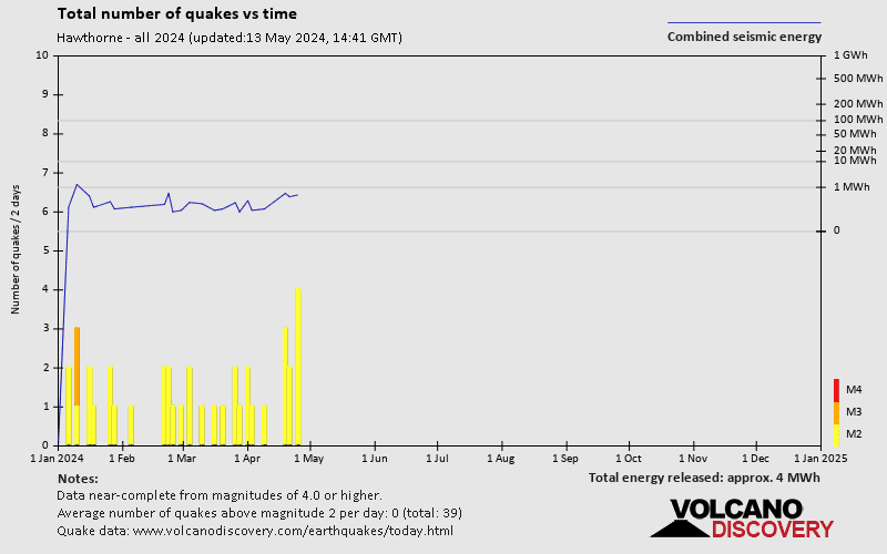
Since 2024, Hawthorne has had 2 quakes of magnitude 3.0 or above and 31 quakes between 2.0 and 3.0. There have been also 209 quakes below magnitude 2.0 which people don't normally feel.
The strongest earthquake in Hawthorne since 2024 had a magnitude of 3.1 and occurred 15 weeks ago:
A light magnitude 3.1 earthquake hit 55 km (34 mi) away from Hawthorne, Nevada, ![]() United States, in the afternoon of Tuesday, Jan 9, 2024 at 5.06 pm local time (America/Los Angeles GMT -7). The quake had a very shallow depth of 10.5 km (7 mi) and was not felt (or at least not reported so).
United States, in the afternoon of Tuesday, Jan 9, 2024 at 5.06 pm local time (America/Los Angeles GMT -7). The quake had a very shallow depth of 10.5 km (7 mi) and was not felt (or at least not reported so).
Date and Time | Mag Depth | ###DIST_LABEL### | Location | Details | Map |
|---|