Latest Worldwide >  Mexico > Chiapas > Huixtla
SEARCH
Latest Quakes | Top 20 | Report a Quake! | Damaging Quakes | By Country/Region | Near Me | Quake Stats | FAQ | News | Volcanoes | Be Safe


SEARCH
| Latest See all | Mag. 3.8 earthquake 46 km northeast of Pijijiapan - Chiapas, Mexico - |
| Strongest past 30 days | Mag. 4.4 North Pacific Ocean - 49 km west of Tapachula de Cordova y Ordoñez, Mexico - Apr 1, 2024 - |
Date and Time | Mag Depth | Nearest Volcano | Location | Details | Map |
|---|---|---|---|---|---|
| Apr 19, 03:05 am (Mexico City) | 3.8 37 km | 96 km (60 mi) to the NW | Info | ||
| Thursday, April 18, 2024 GMT (3 quakes) | |||||
| Apr 18, 03:10 am (Guatemala) | 4.0 99 km | 75 km (47 mi) to the SE | Info | ||
| Apr 18, 03:10 am (Guatemala) | 2.8 82 km | 78 km (49 mi) to the SE | Info | ||
| Apr 17, 09:00 pm (Guatemala) | 2.6 6 km | 83 km (51 mi) to the SE | Info | ||
| Wednesday, April 17, 2024 GMT (1 quake) | |||||
| Apr 17, 03:09 am (Guatemala) | 3.2 220 km | 84 km (52 mi) to the E | Info | ||
| Tuesday, April 16, 2024 GMT (3 quakes) | |||||
| Apr 16, 02:55 am (Mexico City) | 3.3 107 km | 4.4 km (2.7 mi) to the S | Info | ||
| Apr 16, 02:38 am (Merida) | 3.3 54 km | 84 km (52 mi) to the S | Info | ||
| Apr 15, 08:36 pm (Guatemala) | 2.9 195 km | 77 km (48 mi) to the E | Info | ||
| Monday, April 15, 2024 GMT (3 quakes) | |||||
| Apr 15, 03:37 pm (Mexico City) | 3.7 113 km | 47 km (29 mi) to the NW | Info | ||
| Apr 15, 03:20 am (GMT -6) | 3.9 16 km | 78 km (49 mi) to the S | Info | ||
| Apr 15, 12:49 am (Mexico City) | 2.9 77 km | 41 km (26 mi) to the W | Info | ||
| or | ||
Look up quakes! | ||
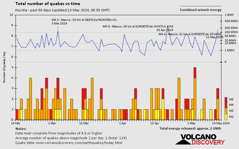
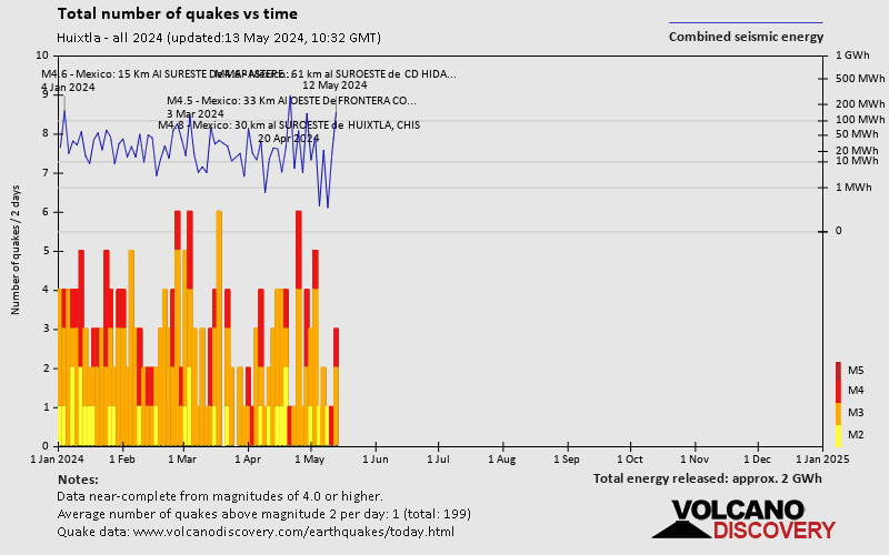
Huixtla has a very high level of seismic activity. Based on data from the past 14 years and our earthquake archive back to 1900, there are about 422 quakes on average per year in or near Huixtla, Chiapas, Mexico. Huixtla has had at least 3 quakes above magnitude 7 since 1900, which suggests that larger earthquakes of this size occur infrequently, probably on average approximately every 40 to 45 years.
The last earthquake in Huixtla occurred 20 hours ago and had a magnitude of 3.8:
A moderate magnitude 3.8 earthquake hit 46 km (29 mi) away from Pijijiapan, Chiapas, ![]() Mexico, in the early morning of Friday, Apr 19, 2024 at 3.05 am local time (America/Mexico City GMT -6). The quake had a shallow depth of 37 km (23 mi) and was not felt (or at least not reported so).
Mexico, in the early morning of Friday, Apr 19, 2024 at 3.05 am local time (America/Mexico City GMT -6). The quake had a shallow depth of 37 km (23 mi) and was not felt (or at least not reported so).
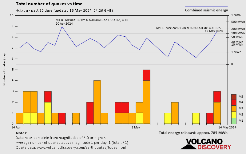
In the past 30 days, Huixtla has been shaken by 6 quakes of magnitude 4.0 or above, 23 quakes between 3.0 and 4.0, and 7 quakes between 2.0 and 3.0.
The strongest earthquake in Huixtla in the past 30 days had a magnitude of 4.4 and occurred 3 weeks ago:
A moderate magnitude 4.4 earthquake occurred in the North Pacific Ocean near the coast of Chiapas State, ![]() Mexico, in the early morning of Monday, Apr 1, 2024 at 1.41 am local time (America/Merida GMT -6). The quake had a moderate depth of 73 km (45 mi) and was not felt (or at least not reported so).
Mexico, in the early morning of Monday, Apr 1, 2024 at 1.41 am local time (America/Merida GMT -6). The quake had a moderate depth of 73 km (45 mi) and was not felt (or at least not reported so).
Date and Time | Mag Depth | ###DIST_LABEL### | Location | Details | Map |
|---|