Latest Worldwide >  Philippines > Central Visayas > Cebu City
SEARCH
Latest Quakes | Top 20 | Report a Quake! | Damaging Quakes | By Country/Region | Near Me | Quake Stats | FAQ | News | Volcanoes | Be Safe


SEARCH
| Latest See all | Mag. 2.7 earthquake Philippine Sea - 17 km northeast of Mactan Island, Philippines - |
| Strongest since 2024 | Mag. 3.1 002 km N 86° W of Murcia (Negros Occidental) - Apr 7, 2024 - |
Date and Time | Mag Depth | Nearest Volcano | Location | Details | Map |
|---|---|---|---|---|---|
| Apr 15, 12:28 am (Manila) | 2.7 3 km | 20 km (12 mi) to the NE | Info | ||
| Apr 14, 01:52 pm (Manila) | 1.6 31 km | 66 km (41 mi) to the SE | Info | ||
| Saturday, April 13, 2024 GMT (1 quake) | |||||
| Apr 14, 12:32 am (Manila) | 2.5 1 km | 90 km (56 mi) to the E | Info | ||
| Friday, April 12, 2024 GMT (3 quakes) | |||||
| Apr 13, 06:29 am (Manila) | 1.7 6 km | 80 km (50 mi) to the NE | Info | ||
| Apr 13, 03:04 am (Manila) | 1.5 22 km | 21 km (13 mi) to the NW | Info | ||
| Apr 13, 01:08 am (Manila) | 1.7 34 km | 76 km (47 mi) to the NE | Info | ||
| Tuesday, April 9, 2024 GMT (1 quake) | |||||
| Apr 10, 02:31 am (Manila) | 1.8 21 km | 93 km (58 mi) to the E | Info | ||
| Saturday, April 6, 2024 GMT (2 quakes) | |||||
| Apr 7, 05:26 am (Manila) | 3.1 1 km | 100 km (62 mi) to the W | Info | ||
| Apr 7, 01:43 am (Manila) | 1.6 34 km | 70 km (44 mi) to the SE | Info | ||
| Friday, April 5, 2024 GMT (1 quake) | |||||
| Apr 5, 09:30 am (Manila) | 2.4 4 km | 88 km (55 mi) to the W | Info | ||
| Thursday, April 4, 2024 GMT (2 quakes) | |||||
| Apr 4, 07:08 pm (Manila) | 2.0 33 km | 77 km (48 mi) to the S | Info | ||

| or | ||
Look up quakes! | ||
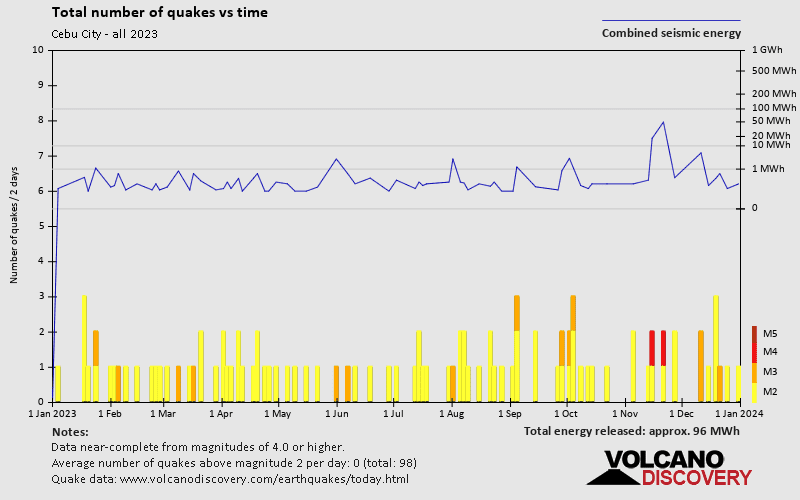
Cebu City has a high level of seismic activity. Based on data from the past 14 years and our earthquake archive back to 1900, there are about 212 quakes on average per year in or near Cebu City, Central Visayas, Philippines. Cebu City has had at least 4 quakes above magnitude 6 since 1900, which suggests that larger earthquakes of this size occur infrequently, probably on average approximately every 30 to 35 years.
The last earthquake in Cebu City occurred 4 days ago and had a magnitude of 2.7:
A light magnitude 2.7 earthquake occurred in the Philippine Sea near Mactan Island island, Philippines, in the early morning of Monday, Apr 15, 2024 at 12.28 am local time (Asia/Manila GMT +8). The quake had a very shallow depth of 3 km (1.9 mi) and was reported felt by some people near the epicenter.
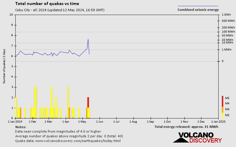
Since 2024, Cebu City has had 2 quakes of magnitude 3.0 or above and 33 quakes between 2.0 and 3.0. There have been also 24 quakes below magnitude 2.0 which people don't normally feel.
The strongest earthquake in Cebu City since 2024 had a magnitude of 3.1 and occurred 12 days ago:
A light magnitude 3.1 earthquake hit 6.1 km (3.8 mi) away from Mansilingan, Western Visayas, ![]() Philippines, in the early morning of Sunday, Apr 7, 2024 at 5.26 am local time (Asia/Manila GMT +8). The quake had a very shallow depth of 1 km (0.6 mi) and was felt widely in the area.
Philippines, in the early morning of Sunday, Apr 7, 2024 at 5.26 am local time (Asia/Manila GMT +8). The quake had a very shallow depth of 1 km (0.6 mi) and was felt widely in the area.