Latest Worldwide >  United States > California > Lone Pine
SEARCH
Latest Quakes | Top 20 | Report a Quake! | Damaging Quakes | By Country/Region | Near Me | Quake Stats | FAQ | News | Volcanoes | Be Safe


SEARCH
| Latest See all | Mag. 1.1 earthquake Inyo County - California, United States - |
| Strongest since 2024 | Mag. 3.9 9 km NNE of Coso Junction - CA - Apr 16, 2024 - |
Date and Time | Mag Depth | Nearest Volcano | Location | Details | Map |
|---|---|---|---|---|---|
| Apr 24, 09:21 am (Los Angeles) | 1.1 2.7 km | 82 km (51 mi) to the SE | Info | ||
| Apr 24, 03:38 am (Los Angeles) | 1.2 2.5 km | 60 km (37 mi) to the S | Info | ||
| Apr 23, 08:59 pm (Los Angeles) | 0.5 2.2 km | 69 km (43 mi) to the S | Info | ||
| Apr 23, 07:59 pm (Los Angeles) | 0.5 2.3 km | 69 km (43 mi) to the S | Info | ||
| Apr 23, 07:21 pm (Los Angeles) | 1.0 2 km | 69 km (43 mi) to the S | Info | ||
| Apr 23, 07:13 pm (Los Angeles) | 1.5 1.8 km | 69 km (43 mi) to the S | Info | ||
| Apr 23, 07:12 pm (Los Angeles) | 0.8 2.4 km | 69 km (43 mi) to the S | Info | ||
| Apr 23, 07:10 pm (Los Angeles) | 2.0 1.8 km | 68 km (43 mi) to the S | Info | ||
| Apr 23, 07:06 pm (Los Angeles) | 1.1 1.7 km | 69 km (43 mi) to the S | Info | ||
| Apr 23, 06:59 pm (Los Angeles) | 1.5 2 km | 69 km (43 mi) to the S | Info | ||
| Apr 23, 06:54 pm (Los Angeles) | 1.4 1.9 km | 69 km (43 mi) to the S | Info |
| or | ||
Look up quakes! | ||
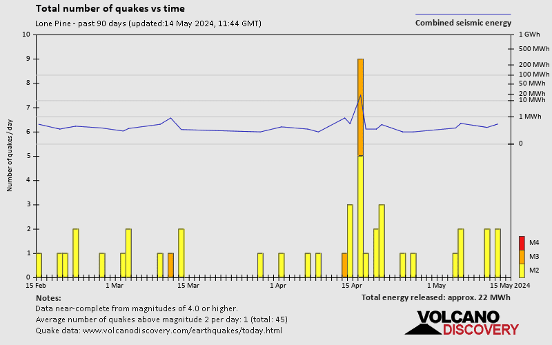
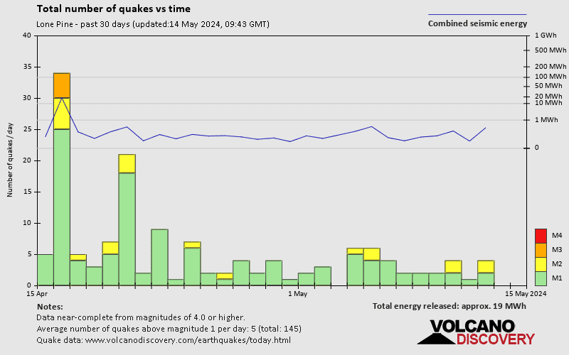
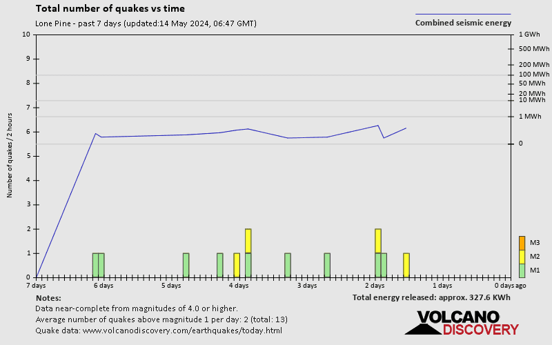
Lone Pine has a high level of seismic activity. Based on data from the past 54 years and our earthquake archive back to 1900, there are about 6,800 quakes on average per year in or near Lone Pine, California, USA. Lone Pine has had at least 14 quakes above magnitude 5 since 1970, which suggests that larger earthquakes of this size occur infrequently, probably on average approximately every 1 to 5 years.
The last earthquake in Lone Pine occurred 2 hours and 49 minutes ago and had a magnitude of 1.1:
A light magnitude 1.1 earthquake hit 35 km (22 mi) away from Ridgecrest, California, ![]() United States, in the morning of Wednesday, Apr 24, 2024 at 9.21 am local time (America/Los Angeles GMT -7). The quake had a very shallow depth of 2.7 km (1.7 mi) and was too small to be felt by people.
United States, in the morning of Wednesday, Apr 24, 2024 at 9.21 am local time (America/Los Angeles GMT -7). The quake had a very shallow depth of 2.7 km (1.7 mi) and was too small to be felt by people.
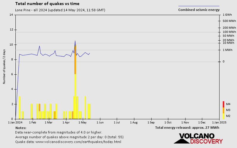
Since 2024, Lone Pine has had 7 quakes of magnitude 3.0 or above and 40 quakes between 2.0 and 3.0. There have been also 534 quakes below magnitude 2.0 which people don't normally feel.
The strongest earthquake in Lone Pine since 2024 had a magnitude of 3.9 and occurred 8 days ago:
A moderate magnitude 3.9 earthquake hit 59 km (36 mi) away from Ridgecrest, California, ![]() United States, in the morning of Tuesday, Apr 16, 2024 at 8.23 am local time (America/Los Angeles GMT -7). The quake had a very shallow depth of 5.1 km (3.2 mi) and was felt by many near the epicenter.
United States, in the morning of Tuesday, Apr 16, 2024 at 8.23 am local time (America/Los Angeles GMT -7). The quake had a very shallow depth of 5.1 km (3.2 mi) and was felt by many near the epicenter.
Date and Time | Mag Depth | ###DIST_LABEL### | Location | Details | Map |
|---|