Latest Worldwide >  Mexico > Oaxaca > Juchitan de Zaragoza
SEARCH
Latest Quakes | Top 20 | Report a Quake! | Damaging Quakes | By Country/Region | Near Me | Quake Stats | FAQ | News | Volcanoes | Be Safe


SEARCH
| Latest See all | Mag. 3.8 earthquake Veracruz - Oaxaca, Mexico - |
| Strongest past 7 days | Mag. 4.1 67 km east of Matias Romero Avendaño - Oaxaca, Mexico - |
Date and Time | Mag Depth | Nearest Volcano | Location | Details | Map |
|---|---|---|---|---|---|
| Apr 24, 04:37 pm (Mexico City) | 3.8 122 km | 97 km (61 mi) to the N | Info | ||
| Apr 24, 03:46 pm (Mexico City) | 3.8 2.1 km | 48 km (30 mi) to the SW | Info | ||
| Apr 24, 04:47 am (Mexico City) | 3.6 5 km | 59 km (36 mi) to the E | Info | ||
| Apr 24, 03:47 am (Mexico City) | 3.8 53 km | 27 km (16 mi) to the S | Info | ||
| Apr 24, 02:29 am (Mexico City) | 3.7 104 km | 75 km (47 mi) to the N | Info | ||
| Apr 24, 02:27 am (Mexico City) | 3.6 101 km | 71 km (44 mi) to the NW | Info | ||
| Apr 24, 01:33 am (Mexico City) | 3.6 5 km | 44 km (27 mi) to the SW | Info | ||
| Apr 24, 12:06 am (Mexico City) | 3.6 129 km | 86 km (54 mi) to the NE | Info | ||
| Tuesday, April 23, 2024 GMT (1 quake) | |||||
| Apr 23, 05:15 pm (Mexico City) | 4.0 130 km | 70 km (44 mi) to the N | Info | ||
| Monday, April 22, 2024 GMT (2 quakes) | |||||
| Apr 22, 07:58 am (Mexico City) | 4.0 123 km | 85 km (53 mi) to the N | Info | ||
| Apr 22, 12:43 am (Mexico City) | 3.5 5 km | 38 km (24 mi) to the SW | Info | ||
| or | ||
Look up quakes! | ||
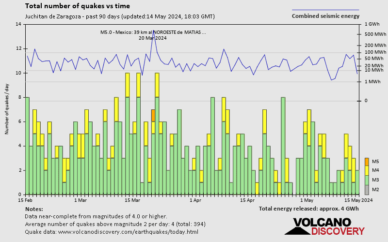
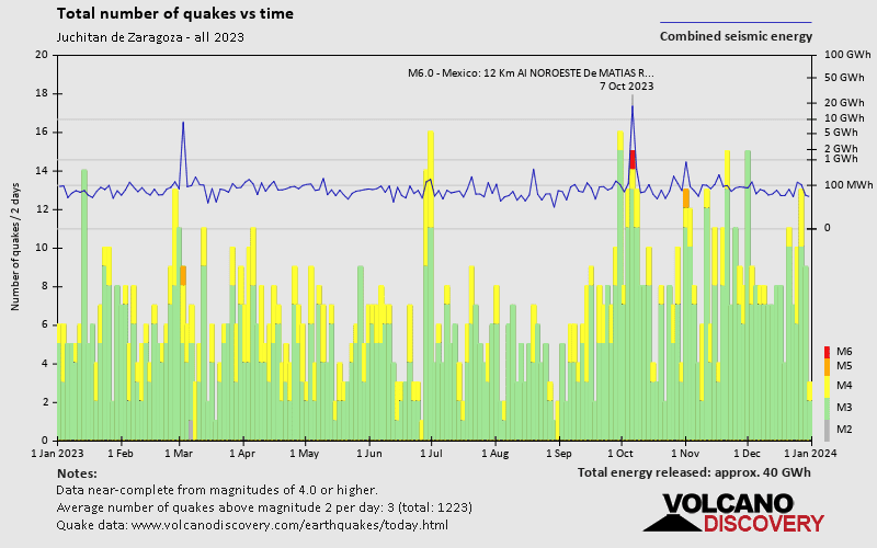
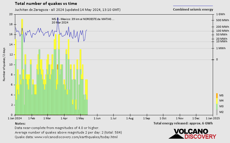
Juchitan de Zaragoza has a high level of seismic activity. Based on data from the past 14 years and our earthquake archive back to 1900, there are about 1,600 quakes on average per year in or near Juchitan de Zaragoza, Oaxaca, Mexico. Juchitan de Zaragoza has had at least 9 quakes above magnitude 6 since 1900, which suggests that larger earthquakes of this size occur infrequently, probably on average approximately every 10 to 15 years.
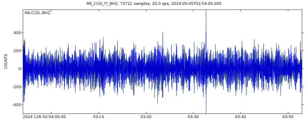
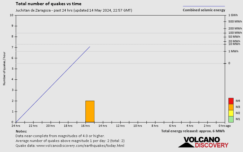
The last earthquake in Juchitan de Zaragoza occurred 7 hours ago and had a magnitude of 3.8:
A moderate magnitude 3.8 earthquake hit 51 km (31 mi) away from Matias Romero Avendaño, Oaxaca, ![]() Mexico, in the afternoon of Wednesday, Apr 24, 2024 at 4.37 pm local time (America/Mexico City GMT -6). The quake had a moderate depth of 122 km (76 mi) and was not felt (or at least not reported so).
Mexico, in the afternoon of Wednesday, Apr 24, 2024 at 4.37 pm local time (America/Mexico City GMT -6). The quake had a moderate depth of 122 km (76 mi) and was not felt (or at least not reported so).
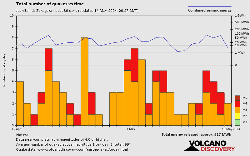
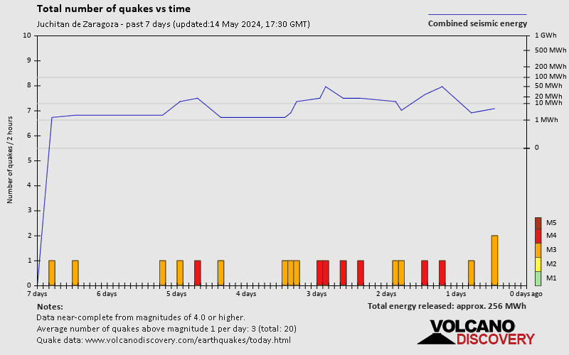
In the past 7 days, Juchitan de Zaragoza was shaken by 4 quakes of magnitude 4.0 or above and 23 quakes between 3.0 and 4.0.
The strongest earthquake in Juchitan de Zaragoza in the past 7 days had a magnitude of 4.1 and occurred 5 days ago:
A moderate magnitude 4.1 earthquake hit 67 km (41 mi) away from Matias Romero Avendaño, Oaxaca, ![]() Mexico, in the early afternoon of Friday, Apr 19, 2024 at 3.49 pm local time (America/Mexico City GMT -6). The quake had a moderate depth of 129 km (80 mi) and was not felt (or at least not reported so).
Mexico, in the early afternoon of Friday, Apr 19, 2024 at 3.49 pm local time (America/Mexico City GMT -6). The quake had a moderate depth of 129 km (80 mi) and was not felt (or at least not reported so).
Date and Time | Mag Depth | ###DIST_LABEL### | Location | Details | Map |
|---|