Contact | RSS | EN | DE | EL | ES | FR | IT | RU

Popocatepetl volcano (Central Mexico) activity update

Tue, 2 Oct 2012, 10:05 | BY: T
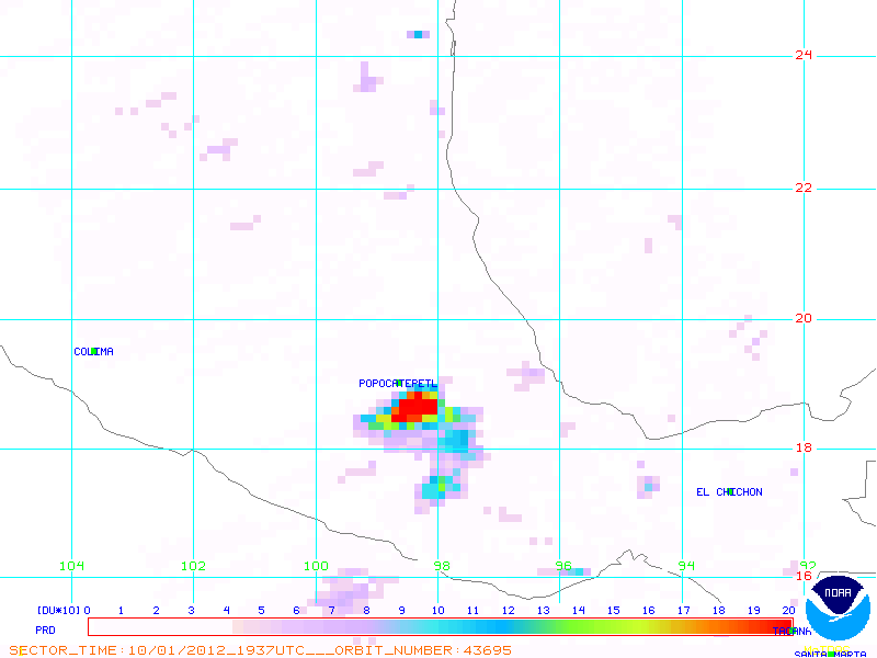
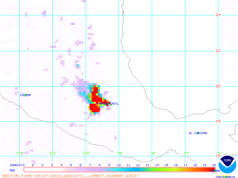
SO2 plume from Popocatépetl on October 1, 2012 (NOAA)
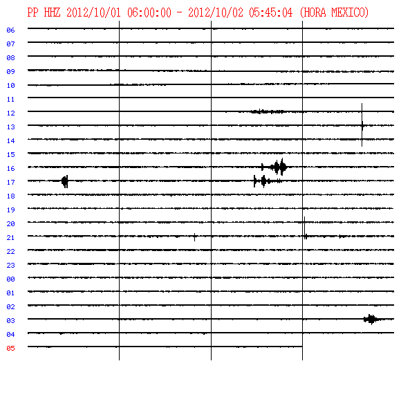
Current seismogram from Popocatepetl (CENAPRED)
During the last 24 h (before 11 am local time 1 Oct), CENAPRED recorded 9 low-intensity exhalations accompanied by emissions of steam and gas. The most important occurred at 15:49 h in the afternoon yesterday and this morning at 05:19 h (local times).
The system also recorded 2 volcano-tectonic earthquakes, both of magnitude 1.1, at 13:52 h and 14:56 h in the afternoon 30 Sep. Additionally, there have been various pulses of very low-energy harmonic tremor reaching a total of 1 h 15 min duration, the most important between 08:25 and 09:05 h this morning.
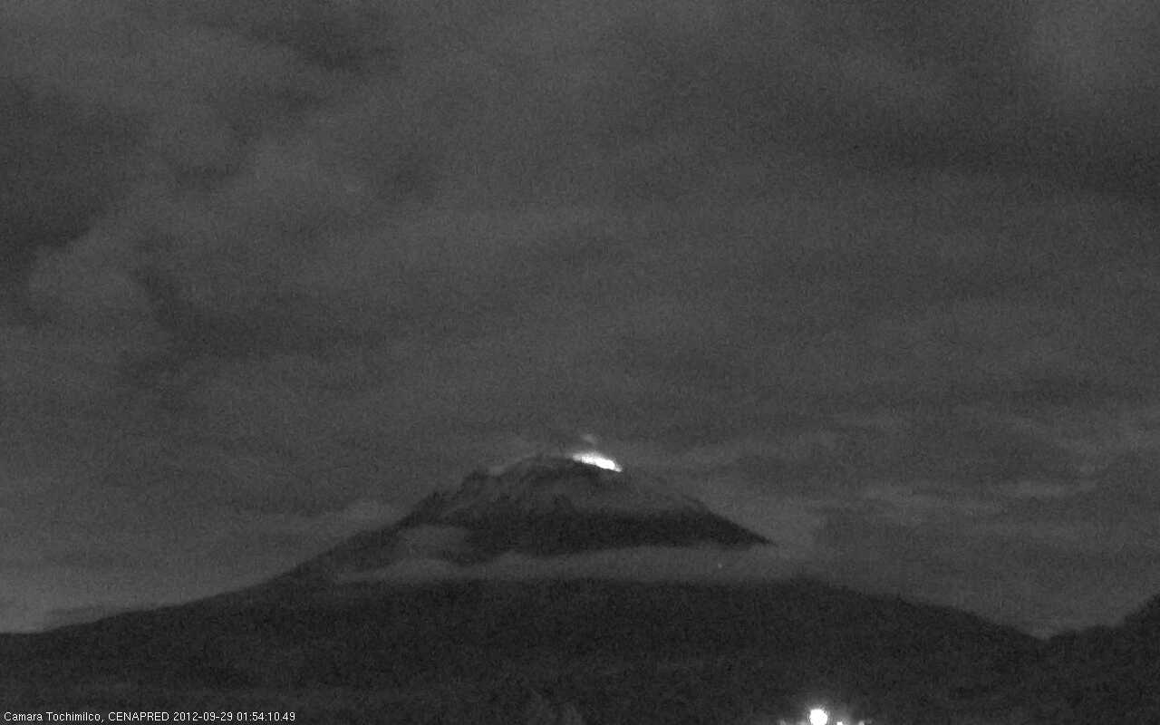
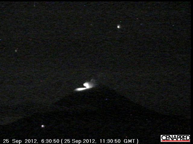
For most of yesterday and today, cloud cover prevented visual observations, but during the night glow could be seen above the crater reaching about 200-300 m height and increased during the occurrence of major exhalations.
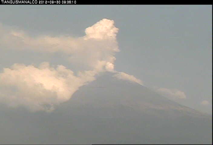
In the morning hours, the volcano showed a plume of water vapor and gas, about 500 m in height, heading south-southeast.
(CENAPRED)

Previous news

Mon, 1 Oct 2012, 10:05

Popocatépetl volcano (Central Mexico) activity update: weak steam explosions (about 1 every 2 hours), crater glow, steaming

About 1 weak explosion every 2 hours were recorded during the past 24 hours and crater glow is visible at night. The steam plume was less pronounced and only about 700 m high yesterday morning. ... Read all
Sun, 30 Sep 2012, 10:05

Popocatépetl volcano (Central Mexico) activity update

Steaming Popocatépetl on 30 Sep
6 weak explosions occurred during the 24 hour interval 28-29 Sep, and a steam plume is rising about 1.5 km above the crater. ... Read all
Show more

Background:

Volcán Popocatépetl, whose name is the Aztec word for smoking mountain, towers to 5426 m 70 km SE of Mexico City to form North America's 2nd-highest volcano.  The glacier-clad stratovolcano contains a steep-walled, 250-450 m deep crater.  The generally symmetrical volcano is modified by the sharp-peaked Ventorrillo on the NW, a remnant of an earlier volcano. 
At least three previous major cones were destroyed by gravitational failure during the Pleistocene, producing massive debris-avalanche deposits covering broad areas south of the volcano.  The modern volcano was constructed to the south of the late-Pleistocene to Holocene El Fraile cone.  Three major plinian eruptions, the most recent of which took place about 800 AD, have occurred from Popocatépetl since the mid Holocene, accompanied by pyroclastic flows and voluminous lahars that swept basins below the volcano.  Frequent historical eruptions, first recorded in Aztec codices, have occurred since precolumbian time.


---


Source: GVP, Smithsonian Institution - Popocatepetl information


Satellite images of Popocatepetl volcano (c)Google Earth View
Stratovolcano 5426 m / 17,802 ft
Central Mexico, 19.02°N / -98.62°W
Current status: erupting (4 out of 5) Popocatépetl volcano eruptions:
1345-47, 1354, 1363(?), 1488, 1504, 1509(?), 1512, 1518, 1519-23(?), 1528, 1530, 1539-40, 1542, 1548, 1571, 1580, 1590, 1592-94, 1642, 1663-65, 1666-67, 1697, 1720, 1802-04, 1827(?), 1834(?), 1852(?), 1919-22, 1923-24, 1925-27(?), 1933, 1942-43, 1947, 1994-95, 1996-2003, 2004-ongoing
Typical eruption style
Dominantly explosive, construction of lava domes. Plinian eruptions at intervals of several centuries or few thousands of years, vulcanian and strombolian activity in intermittent phases.
Popocatépetl Volcano Tours
tour to see the ongoing eruption of Mexico's most active volcano
6 days / 5 nights - Easy
Price 1650 €
no scheduled dates at present
Try our free app!
Volcanoes & Earthquakes - new app for Android
Android | iOS version

More on VolcanoDiscovery

Why is there advertising on this site?

Support us - Help us upgrade our services!

We truly love working to bring you the latest volcano and earthquake data from around the world. Maintaining our website and our free apps does require, however, considerable time and resources.
We need financing to increase hard- and software capacity as well as support our editor team. We're aiming to achieve uninterrupted service wherever an earthquake or volcano eruption unfolds, and your donations can make it happen! Every donation will be highly appreciated. If you find the information useful and would like to support our team in integrating further features, write great content, and in upgrading our soft- and hardware, please make a donation (PayPal or Online credit card payment).

Planned features:Thanks to your past donations, these features have been added recently:
Download and Upgrade the Volcanoes & Earthquakes app to get one of the fastest seismic and volcano alerts online:
Android | IOS
Thank you!
Sources: VolcanoDiscovery / VolcanoAdventures and other sources as noted.
Use of material: Most text and images on our websites are owned by us. Re-use is generally not permitted without authorization. Contact us for licensing rights.
Volcanoes & Earthquakes
VolcanoDiscovery Home
Volcanoes | Earthquakes | Photos | Volcano News | App
Adventure & Study Travel
Tours to Volcanoes and Volcanic Areas: walking tours, photo tours, study tours
Tours & Dates | FAQ | About us
Get our newsletter!
Company info
Contact | Legal info | Terms & conditions
Follow us
Follow us on facebook Follow us on Instagram Follow us on Twitter Visit our Youtube channel
EN | DE | EL | ES | FR | IT | RU
VolcanoDiscovery GmbH, Germany, Reg. nr.: HRB 103744, EU Tax Id: DE 297 465 123 owned and created by
Dr. Tom Pfeiffer, volcanologist, volcano photographer, tour organizer member of
IAVCEI
IAVCEI
Vulkanologische Gesellschaft
Volcanological Society
Ecotourism Greece
Ecotourism Greece
RUV insurance
Insured by R+V
VolcanoDiscovery © 2004- All Rights Reserved | Privacy - Cookie Settings