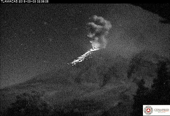
At 2113 on 24 March activity at Popocatépetl increased and a four-hour series of explosions produced steam, gas, and ash emissions that rose 3 km. Incandescent tephra was ejected 800 m onto the NE and SE flanks. The last explosion in the series was detected at 0118 on 25 March.
CENAPRED reported that during 18-24 March the seismic network at Popocatépetl recorded 90-222 daily emissions and 1-13 explosions. Cloud cover often prevented observations of the crater, although ash plumes and nighttime crater incandescence were noted. At 0344 on 22 March an explosion ejected incandescent tephra onto the flanks and produced an ash plume that rose 1 km above the crater rim and drifted NE.
Wed, 11 Mar 2015, 06:00
CENAPRED reported that during 10-17 March the seismic network at Popocatépetl recorded between 6 and 100 gas-and-steam emissions that likely contained some ash; cloud cover mostly prevented observations of the volcano, so on most days ash in the plumes was not confirmed. Two explosions at 1047 on 10 March generated ash plumes that rose 1.5 km above the crater. An explosion on 11 March produced a plume that rose 1 km.
Read allWed, 4 Mar 2015, 15:40
Explosion from Popocatépetl last evening
The activity of the volcano remains at fluctuating, but overall similar levels as during the past months. An increase in tremor yesterday probably corresponded to a phase of active dome growth, accompanied by bright glow visible at the crater and intense degassing and light ash emissions reaching 1500 m height.
Read allWed, 4 Mar 2015, 06:00
CENAPRED reported that during 3-10 March the seismic network at Popocatépetl recorded between 39 and 211 gas, steam, and ash emissions. Crater incandescence at night sometimes increased coincident with emissions. During 3-4 March there were 45 explosions detected; an explosion at 2004 on 3 March ejected tephra 700 m from the crater onto the NE flank, and other explosions ejected material 100 m onto the flanks.
Read allTue, 3 Mar 2015, 12:05
CENAPRED reported that a series of explosions at Popocatépetl from 2250 on 24 February to 0345 on 25 February was accompanied by periods of tremor and Strombolian activity which ejected incandescent material as far as 700 m onto the NE and SE flanks. Additional explosions (19) were detected on 25 February.
Read allWed, 25 Feb 2015, 06:00
CENAPRED reported that a series of explosions at Popocatépetl from 2250 on 24 February to 0345 on 25 February was accompanied by periods of tremor and Strombolian activity which ejected incandescent material as far as 700 m onto the NE and SE flanks. Additional explosions (19) were detected on 25 February. Ashfall was reported in San Martín Texmelucan, San Matías Tlalancaleca, San Salvador el Verde, Santa Rita Tlahuapan, Tlaltenango, Huejotzingo, San Miguel Xoxtla, Domingo Arenas, Santa María Atexcac, and the Puebla airport.
Read allWed, 18 Feb 2015, 06:00
CENAPRED reported that during an overflight of Popocatépetl on 17 February volcanologists observed dome number 55, 150 in diameter, at the bottom of the inner crater (formed in July 2013) which was 100 m below the floor of the main crater. Each day during 18-24 February the seismic network recorded between 47 and 166 low-intensity events, accompanied by steam-and-gas emissions that visibly contained minor amounts of ash most days. Incandescence from the crater was noted some nights.
Read allMon, 16 Feb 2015, 09:30
![Ash eruption from Popocatépetl last evening]()
Ash eruption from Popocatépetl last evening
The volcano's activity remains more or less unchanged with fluctuating levels as to the number of emissions and explosions and seismic activity.
Read allWed, 11 Feb 2015, 06:00
CENAPRED reported that during 10-11 and 11-12 February the seismic network at Popocatépetl recorded 146 and 101 low-intensity events, respectively, accompanied by steam-and-gas emissions that sometimes contained minor amounts of ash. Explosions were also detected, likely from lava-dome growth. On 11 February ashfall was reported in Puebla (~50 km to the E) and in the municipalities of Juan C.
Read allWed, 14 Jan 2015, 06:00
CENAPRED reported that during 14-20 January seismicity at Popocatépetl indicated continuing emissions of water vapor and gas, which occasionally contained ash. Cloud cover sometimes prevented views of the crater. Incandescence from the crater was visible nightly, although sometimes only in conjunction with emissions.
Read allWed, 7 Jan 2015, 06:00
CENAPRED reported that during 7-10 and 13 January seismicity at Popocatépetl indicated continuing emissions of water vapor and gas, which occasionally contained ash; steam-and-gas plumes were visible during 11-12 January. Cloud cover sometimes prevented views of the crater. Incandescence from the crater was visible nightly.
Read allSat, 3 Jan 2015, 11:48
![Glow from Popocatépetl's summit crater]()
Glow from Popocatépetl's summit crater
Activity continues essentially unchanged. A small lava dome continues to grow inside the inner summit crater, with glow visible at night.
Read all