


Latest quakes in or near East Kootenay, British Columbia, Canada - list, stats and map
| Latest See all | Mag. 2.8 earthquake Canada: 43 Km S of Nakusp - BC - Nov 28, 2022 - |
| Strongest since 1970 | Mag. 3.4 British Columbia - Canada - Dec 26, 2001 - |
Date and Time | Mag Depth | Nearest Volcano | Location | Details | Map |
|---|---|---|---|---|---|
| Nov 28, 2022 01:06 am (Vancouver) | 2.8 10 km | 93 km (58 mi) to the W | Info | ||
| Wednesday, December 26, 2001 GMT (1 quake) | |||||
| Dec 26, 2001 09:21 am (Vancouver) | 3.4 1 km | 82 km (51 mi) to the W | Info | ||
| Saturday, September 4, 1999 GMT (2 quakes) | |||||
| Sep 4, 1999 08:18 am (Vancouver) | 2.7 5 km | 71 km (44 mi) to the W | Info | ||
| Sep 4, 1999 08:18 am (Vancouver) | 2.7 5 km | 71 km (44 mi) to the W | Info | ||
| Thursday, March 19, 1998 GMT (1 quake) | |||||
| Mar 19, 1998 01:46 pm (Vancouver) | 3.0 0 km | 87 km (54 mi) to the W | Info | ||
| Monday, November 4, 1991 GMT (1 quake) | |||||
| Nov 4, 1991 01:36 pm (Vancouver) | 2.4 7 km | 66 km (41 mi) to the W | Info | ||
| Sunday, October 27, 1991 GMT (1 quake) | |||||
| Oct 27, 1991 03:21 am (Universal Time) | 3.3 7 km | 67 km (42 mi) to the W | Info | ||
| Wednesday, October 23, 1991 GMT (3 quakes) | |||||
| Oct 23, 1991 07:03 am (Vancouver) | 2.2 7 km | 67 km (42 mi) to the W | Info | ||
| Oct 23, 1991 02:06 am (Vancouver) | 2.2 7 km | 67 km (42 mi) to the W | Info | ||
| Oct 23, 1991 09:00 am (Universal Time) | 3.0 7 km | 67 km (42 mi) to the W | Info | ||
East Kootenay Quake-O-Meter
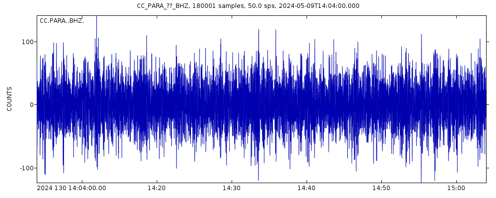
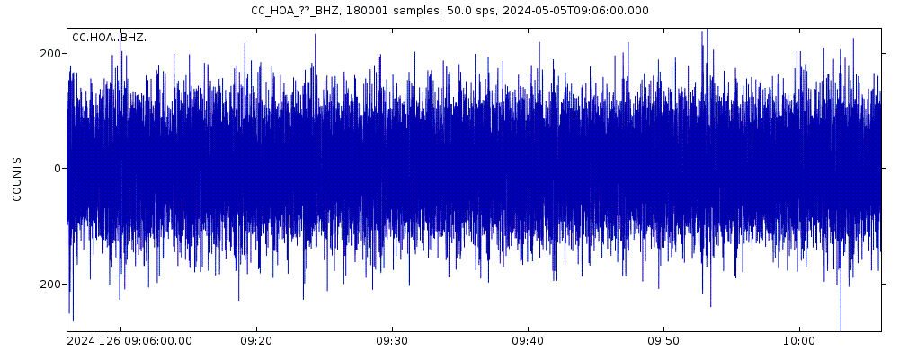
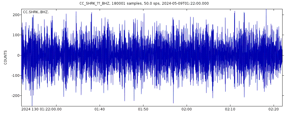
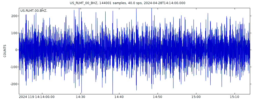
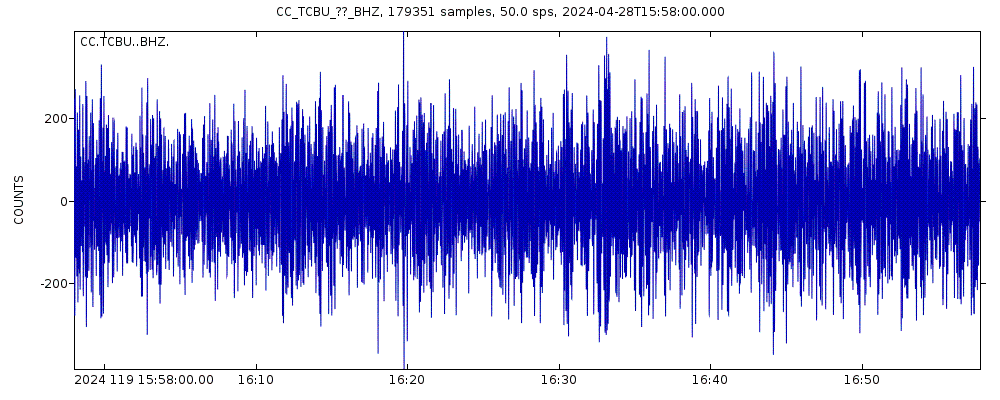
Latest seismic signals
Earthquake Catalog - Look up past earthquakes
| or | ||
Look up quakes! | ||
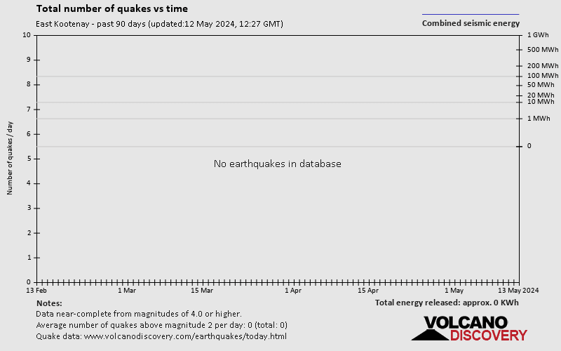
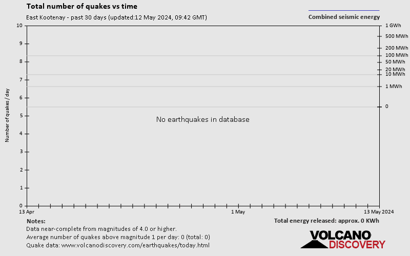
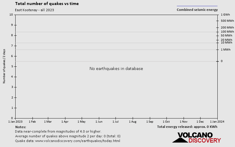
Earthquake statistics
Average number of earthquakes
Number of earthquakes over time


East Kootenay Earthquake FAQ
+When was the latest earthquake in East Kootenay?
The last earthquake in East Kootenay occurred 1 year 20 weeks ago and had a magnitude of 2.8:
A light magnitude 2.8 earthquake hit 43 km (27 mi) away from Nakusp, British Columbia, ![]() Canada, in the early morning of Monday, Nov 28, 2022 at 1.06 am local time (America/Vancouver GMT -7). The quake had a very shallow depth of 10 km (6 mi) and was not felt (or at least not reported so).
Canada, in the early morning of Monday, Nov 28, 2022 at 1.06 am local time (America/Vancouver GMT -7). The quake had a very shallow depth of 10 km (6 mi) and was not felt (or at least not reported so).
+How many quakes were there in East Kootenay since 1970?
There have been 0 quakes of magnitude 3.0+ in or near East Kootenay since 1970.
+What was the strongest quake in East Kootenay since 1970?
The strongest earthquake in East Kootenay since 1970 had a magnitude of 3.4 and occurred 22 years ago:
A light magnitude 3.4 earthquake hit 120 km (75 mi) away from Kelowna, British Columbia, ![]() Canada, in the morning of Wednesday, Dec 26, 2001 at 9.21 am local time (America/Vancouver GMT -7). The quake had a very shallow depth of 1 km (0.6 mi) .
Canada, in the morning of Wednesday, Dec 26, 2001 at 9.21 am local time (America/Vancouver GMT -7). The quake had a very shallow depth of 1 km (0.6 mi) .
Embed or share standalone map
You can use the standalone version of our interactive earthquake map or embed it on your website:Largest Quakes in or near East Kootenay, British Columbia, Canada
Date and Time | Mag Depth | ###DIST_LABEL### | Location | Details | Map |
|---|


