Fagradalsfjall volcano (Reykjanes Peninsula, Iceland): volcanic-seismic crisis continues to evolve, earthquake M 5.4 yesterday
Mon, 1 Aug 2022, 07:43 07:43 AM | BY: MARTIN
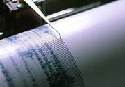
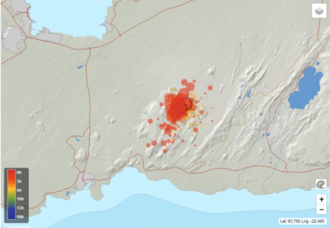
Earthquakes at Reykjanes Peninsula in the last 48 hours (image: IMO)
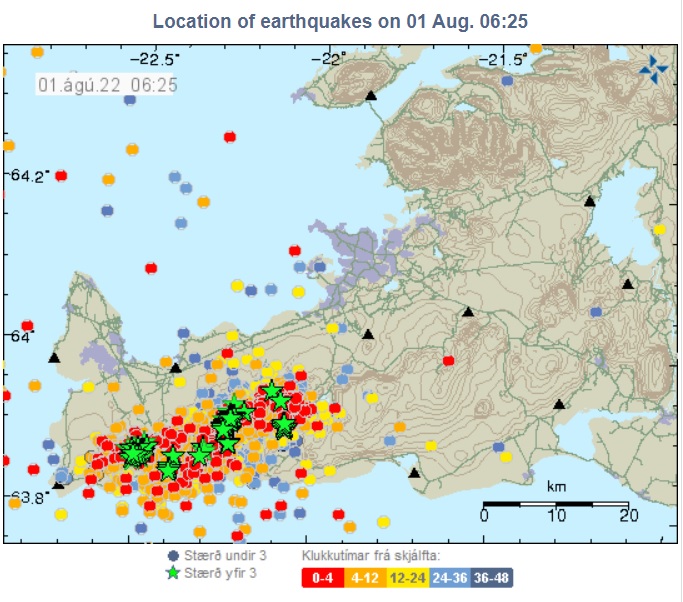
The seismic record of the area (image: IMO)
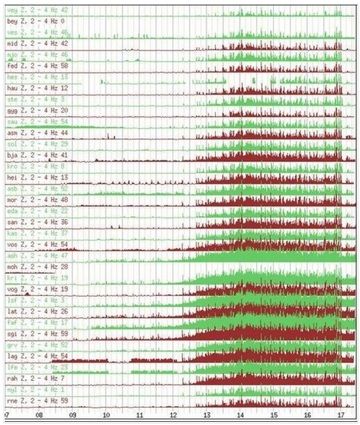
Depth vs. magnitude during 25 Jul - 2 Aug (image: Volcano Discovery)
The seismic activity remains elevated and had been more frequent.
Nearly 3000 earthquakes in total have been detected since the phase began by the Norwegian Meteorological Agency, of which four were recorded with magnitude of 4 and more.
The first earthquakes depths measurements were located at approx. 5-8 km depth, but since 18:00 local time on 30 July have become shallower at depth of about 2-5 km.
At 17:47 local time yesterday, seismic instruments registered the strongest event so far with magnitude
M 5.4 located northeast of Grindavík. Shakes were even visible in the
live stream (see the attached M 5.4 quake video below). The earthquake was widely felt by inhabitants, some minor damages reported.
Magma continues to intrude under the surface and causes voltage changes NE of Grindavík and west of Kleifarvatn lake.
A similar scenario occurred in December last year, but doesn't seem to be powerful enough to trigger an eruption yet.
Source: Icelandic Meteorological Office volcano activity update 1 August 2022 Fagradalsfjall volcano (Reykjanes Peninsula, Iceland): intense seismic activity, alert level raised to Yellow
Sat, 30 Jul 2022, 20:46 20:46 PM | BY: MARTIN
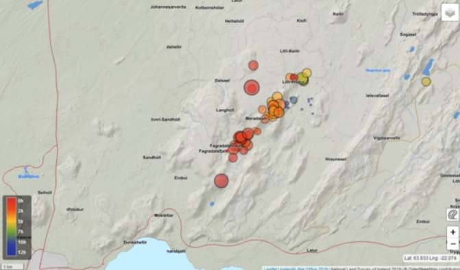
Distribution of quakes in Fagradalsfjall volcano area this afternoon (image: IMO)
An intense swarm of earthquakes has been occurring at Reykjanes peninsula, starting at noon today.
A series of earthquakes have been located northeast of Fagradalsfjall, of which the strongest one was measured with magnitude M 4.0 at 14:03 local time.
Earthquakes were located at depths between 5 and 7 km and are arranged in a northeast-southwest trending linear area. Quakes likely reflect magma intrusion shifting under the surface at shallow level.
Therefore, the Icelandic Meteorological Office (IMO) and authorities raised the alert status to "yellow".
The current hazard poses an increased risk of rockfalls in the area caused by stronger earthquakes. People are advised to avoid steep slopes, cliffs and areas prone collapse.
Source: Icelandic Meteorological Office volcano activity update 30 July 2022Magma likely won't reach surface as models indicate
Update Fri 07 Jan 2022 21:56
The estimated location of the new magma chamber (red line). The black line points out to the previous magma chamber (image: IMO)
GPS instruments continue to detect a mild ground deformation, although the seismic activity at Reykjanes Peninsula continues at decreasing levels.
Numerical models indicate that a current flux of magma is less than half of the pre-eruptive magma volume that started in March.
It is unclear whether the magma batch will reach the surface as happened in March.
The most likely scenario, according to models and the latest measurements, is that the magma may start to solidify in dikes sooner than reach the ground.
"Scientists have pointed out a comparison between the activity at Fagradalsfjall and the activity seen in the Krafla fires", says Michelle Parks, an expert at the Icelandic Meteorological Office.
"In the Krafla fires, about half of the magma intrusions ended with an eruption and the other did not and we could see examples of such activity at Fagradalsfjall. It affects how big the magma intrusions are and how shallow they reach", says Michelle.
Source: Icelandic Meteorological Office volcano activity update 7 January 2022Seismicity continues at reduced levels
Update Mon 03 Jan 2022 18:18
The seismic activity at Reykjanes Peninsula continues at decreasing levels.
About 200 earthquakes have been detected since midnight and have reduced both in numbers and frequency.
Source: Icelandic Meteorological Office volcano activity update 3 January 2022Activity slowed down as seismic swarm decreased
Update Thu 30 Dec 2021 18:41
The seismic activity continues with little changes as a number of earthquakes have been lower than in previous days.
1300 earthquakes have been detected on 28 December which is a lot less in compared with the previous day when 2300 quakes were detected.
A maximum magnitude of 3.7 occurred at 10:22 local time yesterday located east of Kleifarvatn ans was widely felt in the capital area.
GPS and InSAR measurements confirm that the flux of magma is limited to a dike intrusion which is very similar to the pre-eruptive pattern before the eruption started on 19 March.
Source: Icelandic Meteorological Office volcano activity update 30 December 2021More and more frequent earthquakes reflect magma intrusion
Update Wed 29 Dec 2021 04:30
The seismic activity during 21-28 Dec on the Reykjanes peninsula (image: IMO)
600 quakes have been detected since midnight, but have occurred at a lower number than yesterday at the same time.
A maximum magnitude of 3.6 occurred yesterday at 08:25 local time.
Magma migration at depth is still about to pressurize and the increase in the seismic activity is likely a sign of its accumulation.
19000 earthquakes have already been detected in total, mostly with magnitudes of 4 or more since the seismic crisis started on 21 December.
Strong seismic activity continues
Update Tue 28 Dec 2021 00:28

The seismic activity during 21-26 Dec on the Reykjanes peninsula (image: IMO)
The number of earthquakes rapidly increasing but the activity slowed down a bit over the past 24 hours.
18000 earthquakes have already been detected in total, mostly with magnitudes of 4 or more since the seismic crisis started on 21 December.
Strongest earthquakes occurred outside of a potentially eruption site yesterday.
People are advised to avoid the area due to risk of rockfalls.
Continuing ground deformation has reached same pre-eruptive February values
Update Sun 26 Dec 2021 21:54
Ground deformation detected during 20-26 Dec (image: IMO)
The seismicity continues at increasing levels.
Earthquakes have continues to pick up both in numbers and strength.
4 quakes on 24 December were recorded, of which 3 with magnitudes of 4 and 1 with a maximum magnitude of 4.8. 3000 earthquakes have been detected in total since the seismic crisis started on 21 December.
The activity has been intensifying and more frequent under the Fagradalsfjall volcano, but it also occurred near Grindavík and Kleifarvatn.
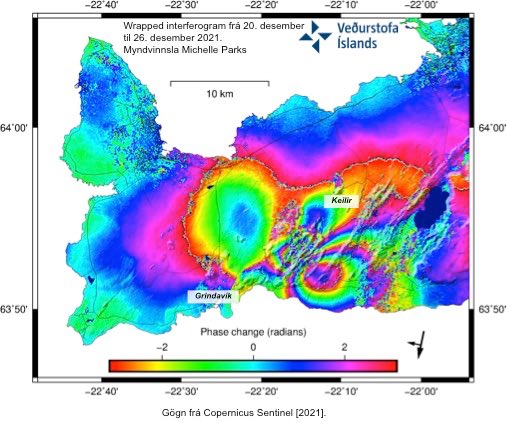
The latest interferogram measurements (InSAR) detected same pre-eruptive ground deformation (see attached image) as seen in late February reflecting continued magma intrusion and migration under the surface, supported also by continued deformation of the surface.
Source: Icelandic Meteorological Office volcano activity update 26 December 2021Intense seismic activity continues
Update Fri 24 Dec 2021 02:10
Ground deformation measured during 16-22 Dec in the area of Fagradalsfjall (image: IMO)
The elevated seismic activity continues.
2000 earthquakes have been detected in total over the last 17 hours at 5-8 km depth suggesting that the flux of magma rising within the volcano is significant and most likely scenario of an imminent eruption is considered to occur in Geldingadalir eruption site.
GPS instruments detected a rapid ground deformation, another tell-tale sign of an impending eruption, which is similar to the pre-eruption measurements before 19 March.
Source: Icelandic Meteorological Office volcano activity update 23 December 2021Seismic activity has been picking up since yesterday, Aviation Color Code raised to orange
Update Thu 23 Dec 2021 01:38
Distribution of earthquakes over the past 24 hours (image: IMO)
The Icelandic Meteorological Office (IMO) detected an
increasing trend of seismic activity began yesterday.
18 quakes at regular intervals of 1 to 10 per minute have been recorded located 2-4 km northeast of Geldingadalir followed by a significant rise of seismic energy at about 00:30 local time.
26 quakes during the past 24 hours were recorded with magnitudes of 3 or more.
1400 earthquakes have been detected in total over the last 24 hours, of which the largest quake with a maximum magnitude of 4.9 occurred at 09:23 local time and was widely felt on the SW corner.
Earthquakes and the increase in seismic activity reflect magma intrusions at shallow level and likely push its way into same dikes as it used to erupt before.
As mentioned in the
latest report, the expansion continues to be measured meaning that magma is probably accumulating under the surface and it's difficult to predict what will happen next.
Based on the increased seismic activity, the IMO has changed the Aviation Color Code to "orange".
Volcano remains quiet even three months since eruption ceased
Update Sun 19 Dec 2021 20:33

Degassing activity at the volcano on 15 Dec (image: MBL)
It has been three months yesterday since the last lava flow was seen at the eruption site. The eruption that began on 19 March, lasted exactly 6 months.
"Of course, it is always a matter of saying exactly when a particular eruption is over, because volcanic activity can be very cyclical", says Sara Barsotti, director of volcanic eruptions at the Icelandic Meteorological Office.
"We have been pointing out ever since the earthquakes in Geldingadalur began that the Reykjanes peninsula is active in terms of earthquakes and volcanic activity, and history tells us that volcanic activity there occurs in cycles", says Sara.
Expansion continues to be measured meaning that magma is probably accumulating under the surface and it's difficult to predict what will happen next.
Eruption site is currently calm for now, slight inflation detected
Update Fri 19 Nov 2021 20:04
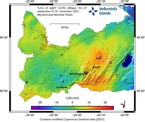
Yellow-to-red colors depict a new inflation on the Reykjanes peninsula (image: IMO)
The effusive eruption at the volcano has already ended or has remained mostly calm since 18 September as lava flows have stopped.
During the eruption, instruments continued to detect a deflation over the eruption site as magma used to leave from the deep chamber and pushed its way up to the surface.
However, GNSS and InSAR instruments observed a new inflation on the Reykjanes peninsula since the end of September. This is likely reflecting a renewed magma intrusion and migration under the surface, supported also by continued deformation of the surface.
A swarm of small earthquakes occurred in late September, located in the south of Keilir area, that may be related to a new batch of magma rising inside the volcano's conduits, although no new ground deformation has been detected during this time period.
The current inflation may not be associated with a new impending eruption.
This may take years or decades what will happens next at Reykjanes peninsula.
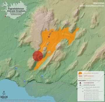
Source: Icelandic Meteorological Office volcano activity update 19 November 2021Fagradalsfjall volcano (Reykjanes peninsula, Iceland): lava overflowed dam and cut off another hiking trail to eruption site
Sat, 18 Sep 2021, 04:14 04:14 AM | BY: MARTIN
Lava flows crossed the hiking trail (image: @EIlyinskaya/twitter)
Aerial view of lava flows filling up the Nátthagi valley (bottom right) (image: @EIlyinskaya/twitter)
A new lava flow map depicts the affected area of hiking trail (image: @EIlyinskaya/twitter)

Lava flows just before the overtook the artificial dam (image: @EIlyinskaya/twitter)
After the resumption of the effusive eruption at the current site one week ago, the activity shows signs of increasing.
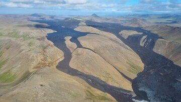
It proves a formation of new lava flows in the upper part of the Nátthagi valley that have continued to fill up the valley.
The effusion of lava continues at elevated discharge rate. This is most likely reflecting at higher pace of the lava that overtook the artificial dam, crossed the hiking trail and leading towards the southern ring road.
Nátthagi valley by now is largely filled with lava flows.
Fagradalsfjall volcano (Reykjanes peninsula, Iceland): high-resolution lava flow map update
Thu, 16 Sep 2021, 05:59 05:59 AM | BY: MARTIN
A new lava flow map of the current eruption from 15 September (image: @geoviews/twitter)
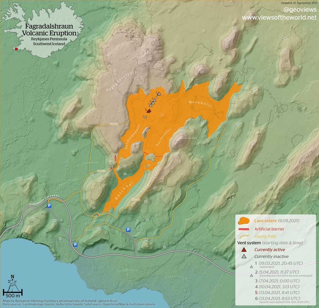
A new lava flow map of the current eruption site has been published and updated today. The map depicts a spreading field of lava that continues to advance gradually and slowly filling up the valley of Nátthagi.
The lava flows have filled up valleys of the Geldingadalir, Meradalir, Meradalur and Nátthagi since the eruption started.
The picture also shows all artificial barriers marked as red lines.
Fagradalsfjall volcano (Reykjanes peninsula, Iceland): activity is back after 7 days of calm and illuminates sky over Grindavik
Tue, 14 Sep 2021, 03:29 03:29 AM | BY: MARTIN
Fountaining continues at the lava field in Geldingadalir valley (image: @EIlyinskaya/twitter)

Glowing steam at the current eruption site from live webcam accompanies the activity at the time of this update (image: Youtube/RÚV)

Lava flow returned to the main crater (image: @szharangi/twitter)

Glowing steam illuminates the sky over Grindavik (image: @Vedurstofan/twitter)
After the longest break of 7 days of apparent calm in the effusive activity, it picked up again on 11 September as
a new lava flow returned to the western flank of the main crater and continues to descend into the Geldingadalir valley.
Small lava fountains are being observed in the field of lava in the Geldingadalir valley and continue to erupt.
The activity quickly intensified accompanied by a strongly rising signal of volcanic tremor indicating rapid magma flux towards the surface.
Timelapse video of the returned effusive eruption on 11 September showing illuminated sky over Grindavik (source: @ar_etsch/twitter)
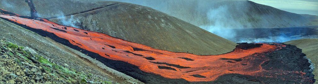
Fagradalsfjall volcano (Reykjanes peninsula, Iceland): eruption continues with regular pulses of lava fountains
Thu, 26 Aug 2021, 16:16 16:16 PM | BY: T

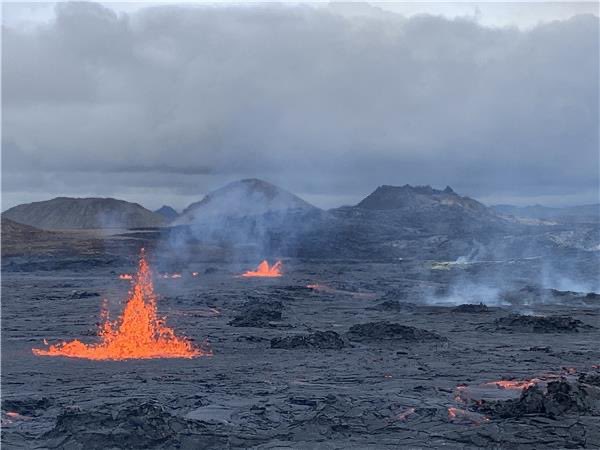
Lava fountain and two lava flows this morning at Fagradalsfjall in Iceland (image: RUV webcam)
The eruption continues in a very similar way as during the past days, with alternating pulses of lava erupting from the vent and quiet phases, at a rhythm of 12-16 hours approximately between the lava pulses.
During the active phases, the crater fills with lava and "boils" over, often forming fountains, and forms multiple lava flows on the surface.
This morning, a new lava flow made its way towards the south and then turned east, while a smaller lava flow emitted a bit further to the west continued southwards towards Natthagi valley (s. image).
The size of the cone is constantly growing although its diameter at the top has decreased. As a consequence of the smaller volume of the bowl-shaped crater, the lava fountains are rising taller.
Activity oscillates like heartbeat from almost absence to spectacular lava overflows
Update Thu 19 Aug 2021 17:42
Eruption in Iceland this evening (image: RUV live webcam)
Oscillating tremor reflecting the regular magma surges (image: IMO)
The eruption continues with no signs of ending, even though it has been going through rhythmically alternating phases of very low to very high levels. Roughly every 24 hours, it changes from one to the other extreme.
When it is high, the crater is filled with a lava lake that overflows on its rims and produces spectacular flows, as can be seen in the recent video below or in the view of the webcam right now (attached); when it is low, there is usually no visible activity at the surface.
Video:
Volcanologist Þorvaldur Þórðarson explained that these lava pulses are likely caused by large gas bubbles rising through the magma in the underground feeding system, pushing the magma out of the vent onto the surface.
Since these lava surges come at very regular intervals, these large gas bubbles must rise in very orderly pattern. Nature likes such regular processes and creates order,- think of the rhythmic behavior of geysers, for example.
The gas bubbles that are responsible for the peaks of activity at Fagradalsfjall are of course orders of magnitude larger than most similar phenomena. Likely, they originate at the top of the magma source in the upper mantle at 15-17 km depth, and once large enough to overcome a critical threshold of some sorts, they start rising and pushing the magma column upwards, resulting in the surface activity seen a short time after.
First visit to our site? If you havn't done it yet,
download the Volcanoes & Earthquakes app to get one of the fastest volcano news online:
Android |
IOS