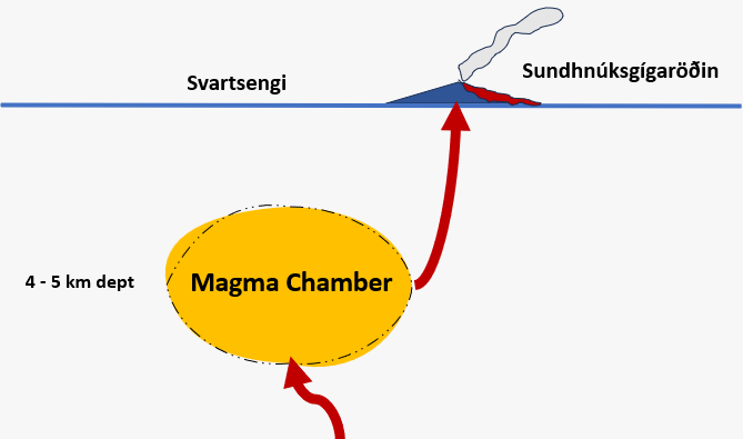
In early April, a new ground uplift started and might follow another magma accumulation within the magma chamber (image: IMO)
In the Sundhnúkur area, there has been a notable shift in volcanic activity with an increasing chance of magma propagation coinciding with the ongoing eruption. This new development marks a departure from the previous cyclical pattern observed since December.
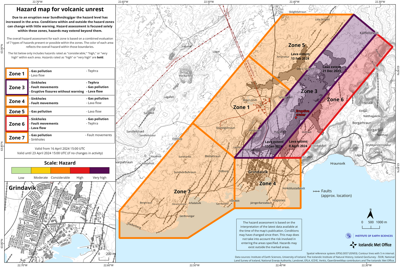
![The map is valid from 16 April until 23 April (image: IMO)]()
The map is valid from 16 April until 23 April (image: IMO)
The updated hazards assessment will be in effect from 15:00 today until 23 April, pending further developments.
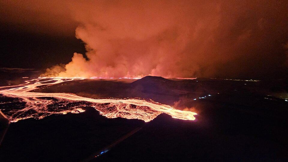
Wed, 17 Apr 2024, 14:00
IMO reported that the eruption at a cone along the fissure within the Reykanes volcanic system continued during 10-15 April. Lava flowed short distance mostly S and the flows thickened near the crater. Inflation continued to be detected and gas emissions continued to drift downwind.
Read allTue, 16 Apr 2024, 02:41
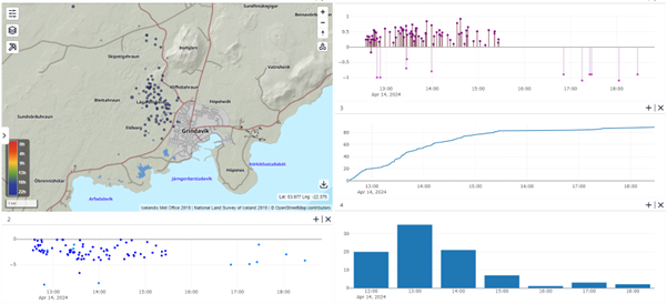
![The map depicts the earthquake locations and a depth graph. In the top right, the chart portrays earthquake magnitudes from 13 April afternoon until 14 April night (image: IMO)]()
The map depicts the earthquake locations and a depth graph. In the top right, the chart portrays earthquake magnitudes from 13 April afternoon until 14 April night (image: IMO)
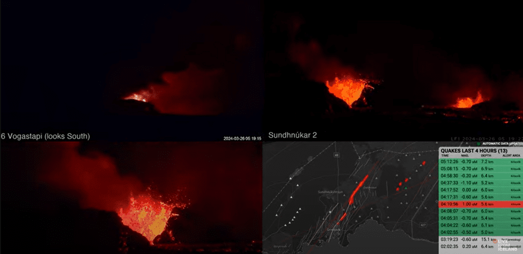
On 14 April afternoon, a sequence of minor earthquakes commenced at Lágafell, situated just northwest of Grindavík. The activity mostly subsided by around 4:30 PM yesterday. Approximately 90 tremors occurred, with the peak activity observed between 1:00 and 2:00 PM when 35 earthquakes were detected. All recorded earthquakes registered under a magnitude of 1, most occurring at depths of about 2-4 kilometers. This series of seismic events is likely a result of crustal tension changes linked to the ongoing landslide in Svarteng, as reported in yesterday's news.
Read allSat, 13 Apr 2024, 03:14
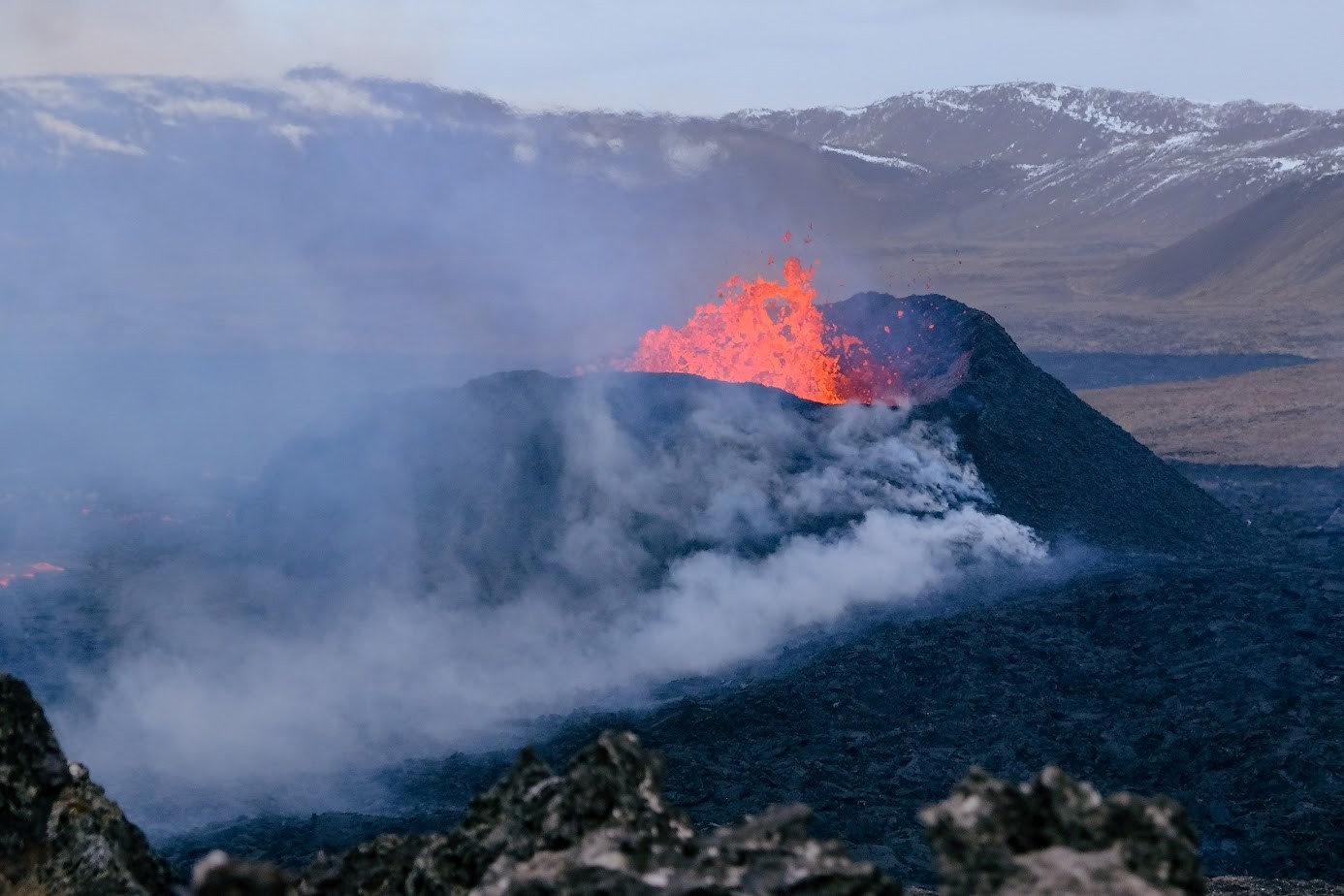
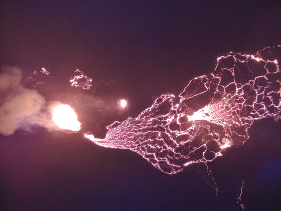
![The frequent spattering in the main crater as seen from Sundhnúk on 10 April (image: IMO)]()
The frequent spattering in the main crater as seen from Sundhnúk on 10 April (image: IMO)
The activity at the eruption site resumes.
Read allWed, 10 Apr 2024, 14:00
IMO reported that the eruption along the fissure within the Reykanes volcanic system continued during 3-9 April. Two cones produced lava flows during the beginning of the week, but by 8 April only the larger, main cone was active. Lava flowed mostly S and the flows thickened near the crater and slightly to the S where the flows were most active.
Read allWed, 10 Apr 2024, 02:58
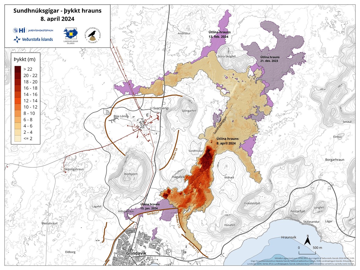
![The lava flow map from 8 April portrays its area and thickness since the beginning of the eruption. The purple color represents the lava flow from December 2023 (image: IMO)]()
The lava flow map from 8 April portrays its area and thickness since the beginning of the eruption. The purple color represents the lava flow from December 2023 (image: IMO)
Experts from the Institute of Natural Sciences and Land Survey of Iceland conducted a survey flight over the eruptions on 8 April, gathering data to estimate the size of the lava bed and lava flow. The results indicate a steady decrease in eruption intensity.
Read allMon, 8 Apr 2024, 03:52
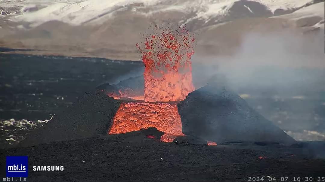
![The oozing red-glowing lava overflow from the main crater vent yesterday (image: mbl.is)]()
The oozing red-glowing lava overflow from the main crater vent yesterday (image: mbl.is)
Yesterday afternoon, a significant change in the ongoing activity occurred at the main crater. It is strongly believed that the magma reservoir began releasing a new batch of magma, potentially indicating a process of magma recharge. This was followed by an increased discharge of lava around 15:30 local time, featuring a several-hour lasting incandescent, fluid lava overflow from the crater vent, containing a cauldron of boiling lava. The situation stabilized around 21:30 local time last night.
Read allSat, 6 Apr 2024, 21:01
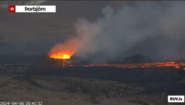
![The one and only active spatter cone as of 20:40 local time today (image: RUV)]()
The one and only active spatter cone as of 20:40 local time today (image: RUV)
Another significant change appeared at the eruption site over the past 48 hours.
Read allFri, 5 Apr 2024, 06:39
![The lava layering from the northern crater (image: IMO)]()
The lava layering from the northern crater (image: IMO)
The eruption continues from two active craters and remains essentially unchanged since the
last update.
Read allThu, 4 Apr 2024, 03:02
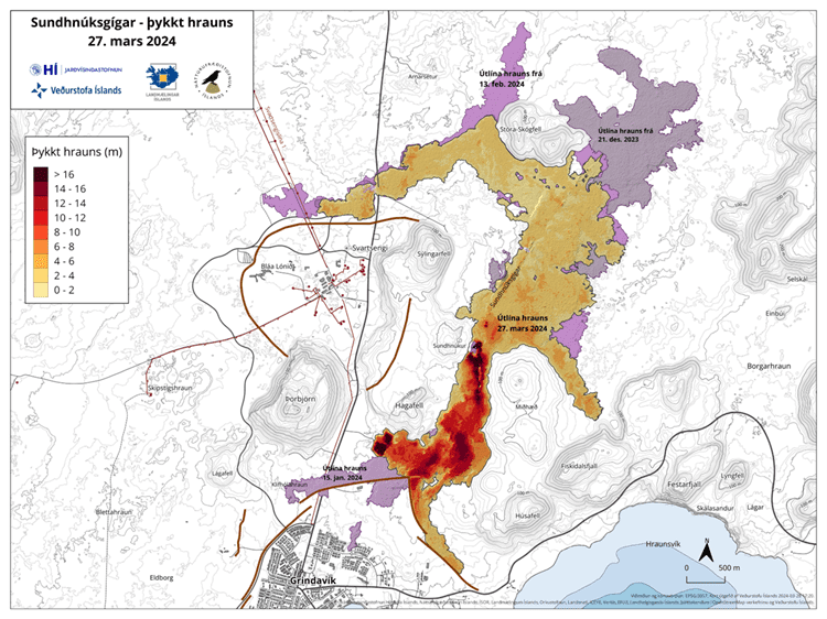
![The lava flow map from 27 March portrays its area and thickness since the beginning of the eruption. The purple color represents the lava flow from December 2023 (image: IMO)]()
The lava flow map from 27 March portrays its area and thickness since the beginning of the eruption. The purple color represents the lava flow from December 2023 (image: IMO)
A recent lava flow map has been released by experts at Land Surveying Iceland.
Read allWed, 3 Apr 2024, 18:00
IMO reported that an average lava effusion rate from vents along the fissure within the Reykanes volcanic system was estimated to be 7.8 (plus or minus .7) cubic meters per second during 20-27 March, based on a 27 March satellite image. The lava-flow field was about 5.99 square kilometers with an approximate volume of 25.7 (plus or minus 1.9) million cubic meters. Lava flows continued to advance S over older flows emplaced during the beginning of the eruption.
Read allTue, 2 Apr 2024, 12:46
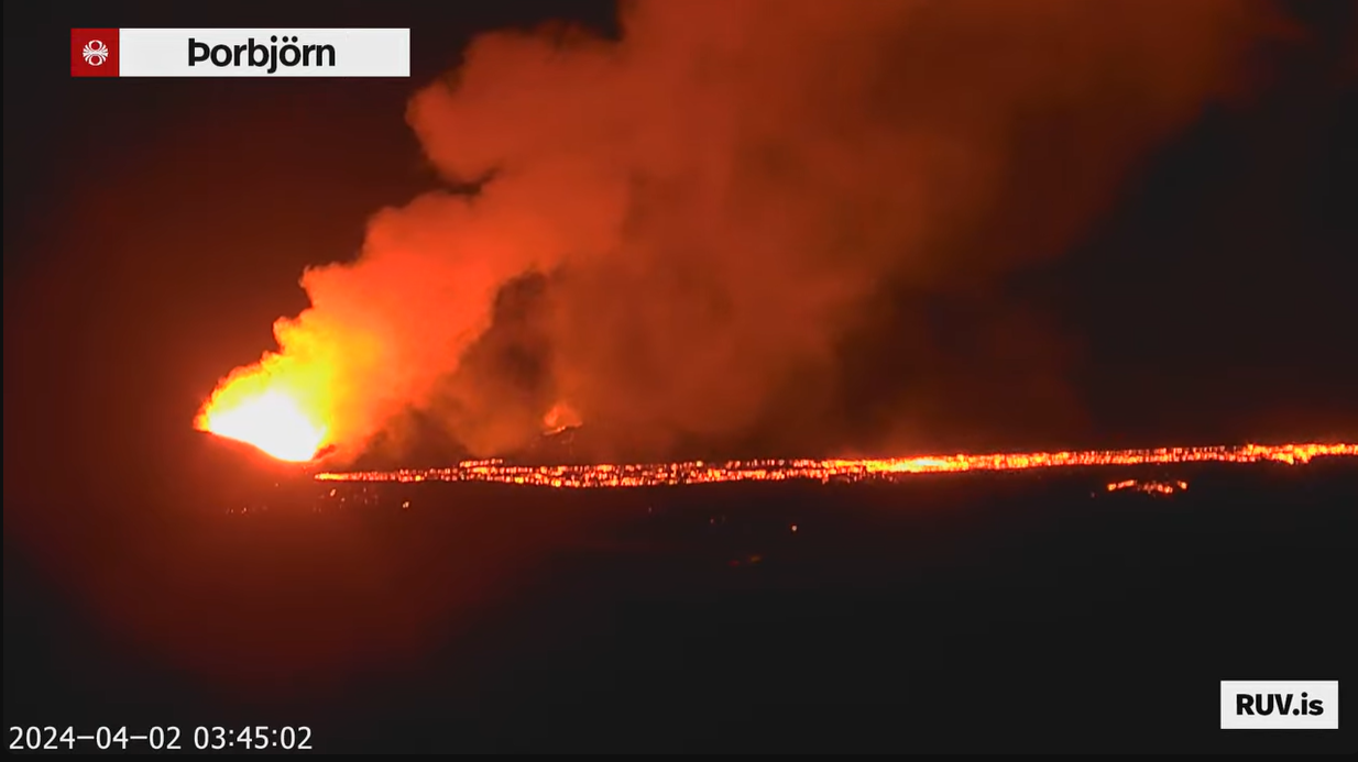
![Two cinder cones continue to be active (image: RUV.is)]()
Two cinder cones continue to be active (image: RUV.is)
The effusive eruption at the site continues at stable levels.
Read allThu, 28 Mar 2024, 10:16
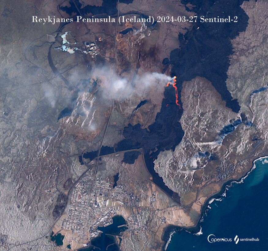
![The latest cloud-free satellite image showing three main crater vents and the lava flow (image: Sentinel-2)]()
The latest cloud-free satellite image showing three main crater vents and the lava flow (image: Sentinel-2)
The eruption continues at stable but at low-level values.
Read allWed, 27 Mar 2024, 15:00
According to the Icelandic Meteorological Office (IMO), eruptive activity along the fissure that opened on 16 March began to stabilize on 20 March, with vents remaining in the same locations as previous days where cones had been built. The lava flows traveled S on top of older flows from the previous episodes in December 2023 and January-February 2024. Little or no change was observed at the flow fronts near Suðurstrandarvegur (the southern coast road) and Svartsengi.
Read allTue, 26 Mar 2024, 05:22
![The activity in craters continues at diminished levels (image: Live from Iceland webcam)]()
The activity in craters continues at diminished levels (image: Live from Iceland webcam)
The eruption has subsided over the past 24 hours.
Read allSat, 23 Mar 2024, 18:36
![The eruption continues at well-balanced levels (image: RUV.is webcam)]()
The eruption continues at well-balanced levels (image: RUV.is webcam)
The volcanic eruption continues with relatively steady activity.
Read allSat, 23 Mar 2024, 05:09
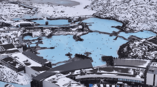
![The Blue Lagoon (image: <link https://www.ruv.is/frettir/innlent/2024-03-22-vedurstofan-varar-vid-aukinni-gasmengun-408186 _blank>RUV.is</link>)]()
The Blue Lagoon (image: <link https://www.ruv.is/frettir/innlent/2024-03-22-vedurstofan-varar-vid-aukinni-gasmengun-408186 _blank>RUV.is</link>)
The Blue Lagoon announced today that its offices will remain closed until Monday, March 25. The closure is attributed to the volcanic eruption that commenced on March 16, prompting an evacuation and temporary shutdown.
Read allSat, 23 Mar 2024, 04:35
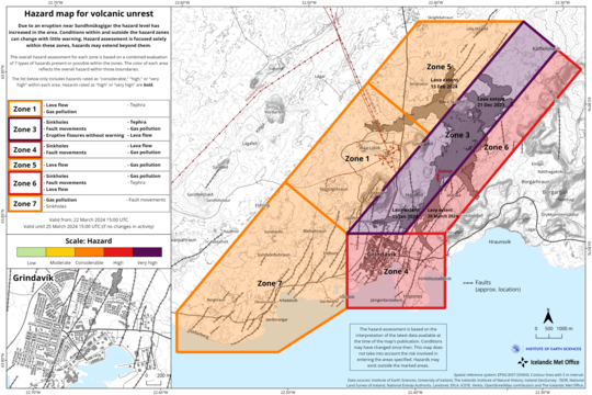
![The map is valid from 22 March until 25 March (image: IMO)]()
The map is valid from 22 March until 25 March (image: IMO)
The hazard assessment, effective from 15:00 from March 22, until 15:00 on March 25, has been updated. The probability of gas emissions poses a heightened risk across all regions compared to previous days due to adverse weather forecasts for the upcoming days and increased measured levels of sulfur dioxide (SO2) emissions from both the eruption sites and the lava field.
Read allFri, 22 Mar 2024, 08:11
Scientists and authorities expressed first concerns about lava entering the town of Grindavík.
Read allThu, 21 Mar 2024, 19:50
![Aerial insight into cinder cones within the eruptive fissure (image:IMO)]()
Aerial insight into cinder cones within the eruptive fissure (image:IMO)
No significant change in the activity has occurred during the past 24 hours and hence the eruption persists at well-balanced levels.
Read allWed, 20 Mar 2024, 17:51
![The spatter rampart is being constructed due to the ongoing fountaining activity (image: RUV webcam))]()
The spatter rampart is being constructed due to the ongoing fountaining activity (image: RUV webcam))
The activity has been stable over the past 24 hours.
Read allWed, 20 Mar 2024, 15:00
After about 40 minutes of increased seismicity and ground deformation, a fissure eruption within the Reykanes volcanic system began at 2023 on 16 March near the older Sundhnúkagígar crater row on the Reykjanes Peninsula, prompting IMO to raise the Aviation Color Code to Red (the highest level on a four-color scale). According to a news report about 700 people at the Blue Lagoon spa and the few people in Grindavík were evacuated within about a 30-minute period. IMO noted that the fissure quickly lengthened to 2.9 km and that the length and location was similar to the 8 February fissure eruption.
Read allWed, 20 Mar 2024, 04:00
![Reflection electron images of (a) lava rapidly cooled (sampled in January 2024) and (b) highly vesicular pyroxene (from March 17, 2024) (image: The University of the Earth Science ...]()
Reflection electron images of (a) lava rapidly cooled (sampled in January 2024) and (b) highly vesicular pyroxene (from March 17, 2024) (image: The University of the Earth Science Institute of Iceland)
The University of the Earth Science Institute of Iceland published results of petrographic and geochemical analysis from the ongoing eruption on the Reykjanes Peninsula.
Read allTue, 19 Mar 2024, 14:05
![Spatter ramparts has been constructing above fissure vents (image: RUV webcam)]()
Spatter ramparts has been constructing above fissure vents (image: RUV webcam)
The activity at the eruption site continues at stable levels.
Read allTue, 19 Mar 2024, 04:14
![The map is valid from 18 March until 20 March (image: IMO)]()
The map is valid from 18 March until 20 March (image: IMO)
The Icelandic Met Office has recently released an updated hazard assessment map for the Grindavík area due to the ongoing eruption. The risk levels have decreased in zones 5 and 7. Zones 1, 3, 4 and 6 remain unchanged.
Read allMon, 18 Mar 2024, 13:52
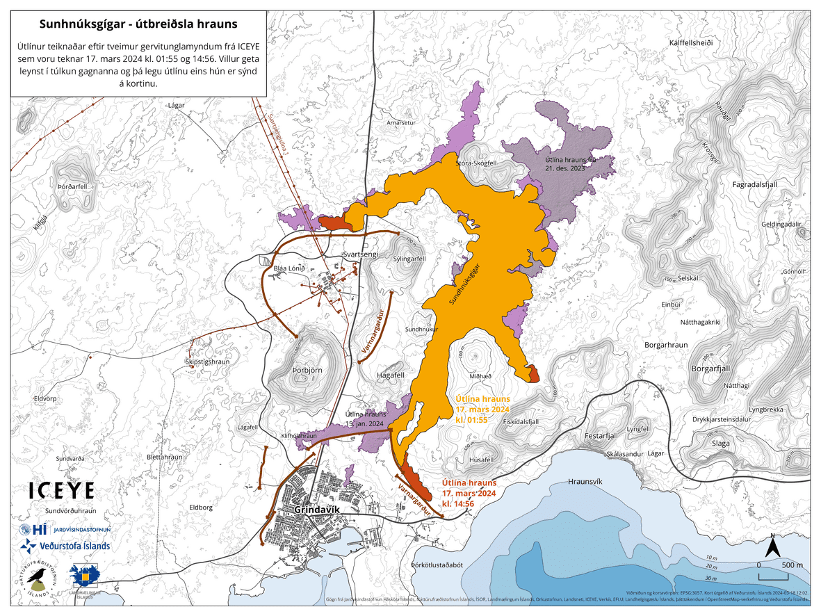
![The lava flow area and its extension within a 12-hour time span. The orange color indicates the initial spreading of the lava at 01:55 local time last night, and the red color depi ...]()
The lava flow area and its extension within a 12-hour time span. The orange color indicates the initial spreading of the lava at 01:55 local time last night, and the red color depicts the lava development from 15:00 local time yesterday. Purple colours show the lava from previous eruptions (image: IMO)
The activity has been stable since late yesterday.
Read allMon, 18 Mar 2024, 04:08
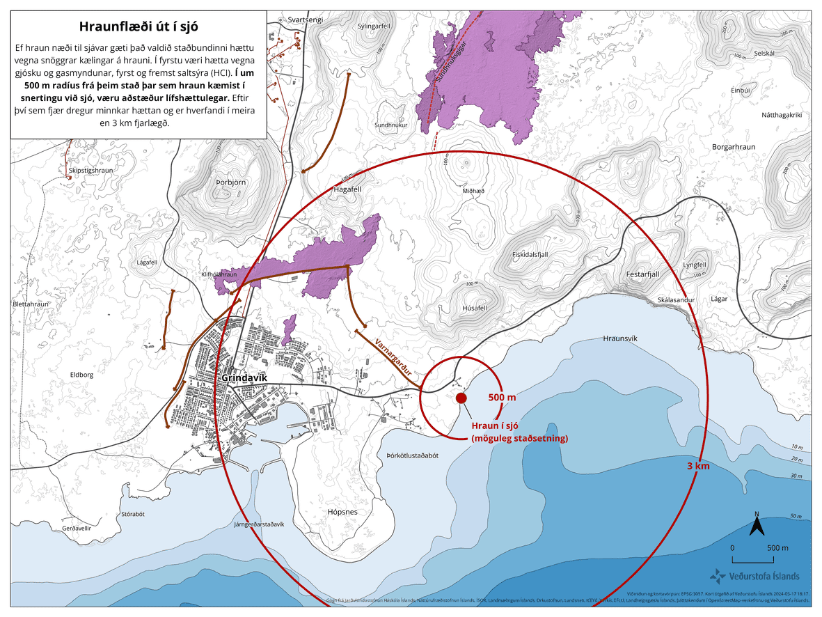
![The map portraying the impact area if lava were to reach the sea (image: IMO)]()
The map portraying the impact area if lava were to reach the sea (image: IMO)
The Icelandic Met Office, Norwegian Meteorological Institute, and Civil Defense have jointly released a map depicting potential scenarios if lava were to reach and enter the sea.
Read allSun, 17 Mar 2024, 17:18
![The spattering activity continues from three fissure vents (image: RUV.is)]()
The spattering activity continues from three fissure vents (image: RUV.is)
The activity at the eruption site continues at reduced levels over the past few hours.
Read allSun, 17 Mar 2024, 08:17
![The lava travels through the main road (image: IMO)]()
The lava travels through the main road (image: IMO)
The effusive eruption resumes.
Read all