IG reported that the eruption at Sierra Negra that began on 26 June was divided into two main phases. The first and most energetic phase lasted one day (26 June) and was characterized by the opening of five fissures and lava flows traveling as far as 7 km from the vents. Lava was only produced from fissure 4 during the 57-day-long second phase (27 June-23 August), with lava reaching the sea on 6 July and expanding the coastline.
IG reported that during 20-21 August both steam-and-gas emissions and incandescence from lava flows were visible on the Sierra Negra webcam. No activity was noted when the weather was clear during 22-28 August.
IG reported that lava effusion at Sierra Negra continued at variable intensities. The most intense pulses, recorded on 4 and 9 August, were accompanied by major episodes of seismic tremor; activity slightly declined after 9 August. On 15 August satellite images showed lava from Fissure 4 continuing to enter the ocean.
IG reported that the eruption at Sierra Negra continued during 7-14 August. Incandescence from active NNW lava flows was visible almost nightly. A steam-and-gas plume rose 1.8 km a.s.l. and drifted W on 7 August.
IG reported that the eruption at Sierra Negra continued during 1-7 August. Incandescence from active lava flows was visible daily. An increase of tremor began at 2220 on 3 August and lasted two hours, signifying a new pulse of activity on the N flank.
IG reported that the eruption at Sierra Negra continued during 25-31 July. Sulfur dioxide flux was as high as about 1,400 tons per day (on 28 July), and daily counts of volcano-tectonic and long-period events were 24-65 and 3-32, respectively. Nightly incandescence from advancing lava flows was visible.
IG reported that the eruption at Sierra Negra continued through 23 July, and continued to vary in intensity. Four fissures had initially opened on 26 June, at the start of the eruption. Fissure 1 is 4 km long and located at the edge of the caldera in the area of Volcán Chico.
Based on satellite data and wind model data, the Washington VAAC reported that on 11 July gas-and-ash plumes from Sierra Negra rose 3.7 km (12,000 ft) a.s.l. and drifted almost 85 km W. Gas plumes on 13 July drifted N, NW, and SW.
Wed, 4 Jul 2018, 06:00
IG reported that a new magmatic intrusion at Sierra Negra was heralded by a M 5.2 earthquake recorded at 1830 on 4 July, and followed by 68 events between M 1.1 and 3.9. Seismic tremor began to be recorded at 1700 on 7 July by a station on the NE edge of the caldera. At the same time satellite data showed an increase in the intensity of the thermal anomaly on NW flank (it had decreased the previous day).
Read allWed, 27 Jun 2018, 11:45
Wed, 27 Jun 2018, 10:06
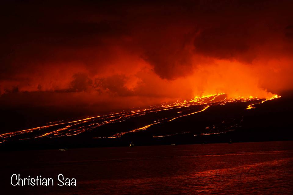
![The nighttime sky is turned red due to the red glow from the lava fountaining from the fissures, forming multiple rivers flowing towards the ocean (image shared on Facebook page of Christian Saá)]()
The nighttime sky is turned red due to the red glow from the lava fountaining from the fissures, forming multiple rivers flowing towards the ocean (image shared on Facebook page of Christian Saá)
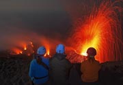
After two prolonged seismic crises with earthquakes up to M5.3, the Sierra Negra volcano entered a new eruptive phase with strong fountaining and multiple lava flows on Tuesday 26 June 2018 - the first volcanic activity since its last eruption in 2005.
Read allWed, 27 Jun 2018, 06:00
Based on video and photos shared by Parque Nacional Galápagos staff, IG reported that the eruption at Sierra Negra that began at 1340 on 26 June originated from several fissures on the N flank and one within the caldera. The flank flows reached the sea between Elizabeth Bay and Punta Morena. A gas-and-ash plume rose about 10.5 km and drifted W.
Read allWed, 20 Jun 2018, 06:00
On 22 June IG reported increased seismic activity at Sierra Negra on the S end of Isabela Island; the largest event, a M 4.2, was recorded at 0624 and felt in El Cura and San Joaquín, NE of the volcano. A M 5.3 earthquake was detected at 0315 on 26 June, occurring at a depth of 5.3 km below Sierra Negra. The event was strongly felt on the upper flanks and in Puerto Villamil (23 km SE).
Read allThu, 14 Jun 2018, 07:22
![Earthquake locations under Sierra Negra volcano since Jan 2017 (image: IG)]()
Earthquake locations under Sierra Negra volcano since Jan 2017 (image: IG)
A seismic crisis has started under the volcano recently, suggesting that the volcano could be approaching a new eruption in the near or medium-term future (weeks to months).
Read allWed, 6 Jun 2018, 06:00
On 8 June IG reported a continuing high level of seismicity at Sierra Negra, characterized by a larger number and magnitude of earthquakes, indicating magma movement. The number of events per day had been significantly increasing since mid-2016. In the previous 10 days there was an average of 42 local events/day; on 25 May there were 104 events, the largest number of earthquakes per day recorded since 2015.
Read allMon, 14 Nov 2005, 14:42
Lava stopped flowing at Sierra Negre volcano on the evening of 30th of Oct. 2005.
However, even 10 days after the end of the eruption, fires caused by the eruption continued, threatening some rare plants on the island. About 500 hectars in the National Park were burning on the W flank of the volcano in an area called Pampas de Velasco. This area is home to the largest population in the islands of the rare endemic plant Scalesia cordata, which was threatened by the fires. Therefore, the local authorities decided to intervene and take costly measures to extinguish the bushfire.
Sat, 29 Oct 2005, 11:32
The eruption of Sierra Negre continues with lava flows confined to the vast caldera; it does not pose risks to populated areas. In the meanwhile, a group of scientists from the Geophysical Institute of Ecuador have visited the site and posted a detailed report about the eruption's first 3 days: it can be downloaded here.
Wed, 26 Oct 2005, 06:00
According to IG, an eruption began at Sierra Negra on the S end of Isabela Island on 22 October at 1730 when an explosion was heard by many people in the town of Villamil, 20 km SE of the volcano. The eruption was preceded by a seismic event on 22 October at 1438, and by earthquakes on 19 October and 2 weeks earlier. The Washington VAAC recorded an ash cloud on satellite imagery at 1745 at a height of ~15.2 km (50,000 ft) a.s.l. moving SW, and a very large hotspot.
Read allTue, 25 Oct 2005, 14:12
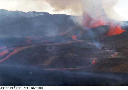
![Eruption of Sierra Negre volcano on 25 Oct. 2005 (Photo: Jorge Penafiel / El Universo)]()
Eruption of Sierra Negre volcano on 25 Oct. 2005 (Photo: Jorge Penafiel / El Universo)
The eruption is continuing from a fissure inside the E part of the caldera of Sierra Negre, with lava fountains up to 200 m tall and large lava flows that have now covered about 20% of the caldera floor. Good eruption viewing possibilities are from a lookout on the caldera rim in the El Cura area.
Mon, 24 Oct 2005, 15:49
![Eruption plume of the opening phase of Sierra Negra volcano on 23 Oct. 2005 (photo: Greg Arancea, published on "El Universo" newspaper)]()
Eruption plume of the opening phase of Sierra Negra volcano on 23 Oct. 2005 (photo: Greg Arancea, published on "El Universo" newspaper)
First photographs and more detailed information about the large eruption of Sierra Negre are emerging. As on Monday, 24 October, lava flows from a fissure have travelled 9-10 km away from the fissure. The eruption is accompanied by strong lava fountains. Near the eruption site, the terrain consists mainly of older, unvegetated lava flows. Two flows are travelling towards Elizabeth Bay, while a third one is heading towards Cartago Bay, both uninhabited areas.
The popoluation of Puerto Villamil is not threatened because of its sheltered position at the S of the island.
Read allSun, 23 Oct 2005, 22:24
Sierra Negra volcano, also called "El Chico", on Isabela Island, Galapagos, erupted yesterday at 17h30 local time. As the Ecuadorian newspaper "El Universo" reports, an ash column estimated between 20 to 30 km high was observed. According witnesses from Santa Cruz island, two lava flows reached Elizabeth Bay, an uninhabitated settlement area close to the volcano. The island's main town, Puerto Villamil, 25 kilometers (15 miles) away, is not threatened by the eruption. Sierra Negro last erupted 1978.
Read allWed, 19 Oct 2005, 06:00
A large eruption began at Sierra Negra on 22 October. According to the Washington VAAC, the eruption began around 1645, sending an ash cloud to ~12.8 km (42,000 ft) a.s.l. that drifted SW.
Read all