Modern volcanic hazards shed light on historic caldera-forming events
Wed, 3 Mar 2021, 09:36 09:36 AM | BY: ELEANOR WRIGHT
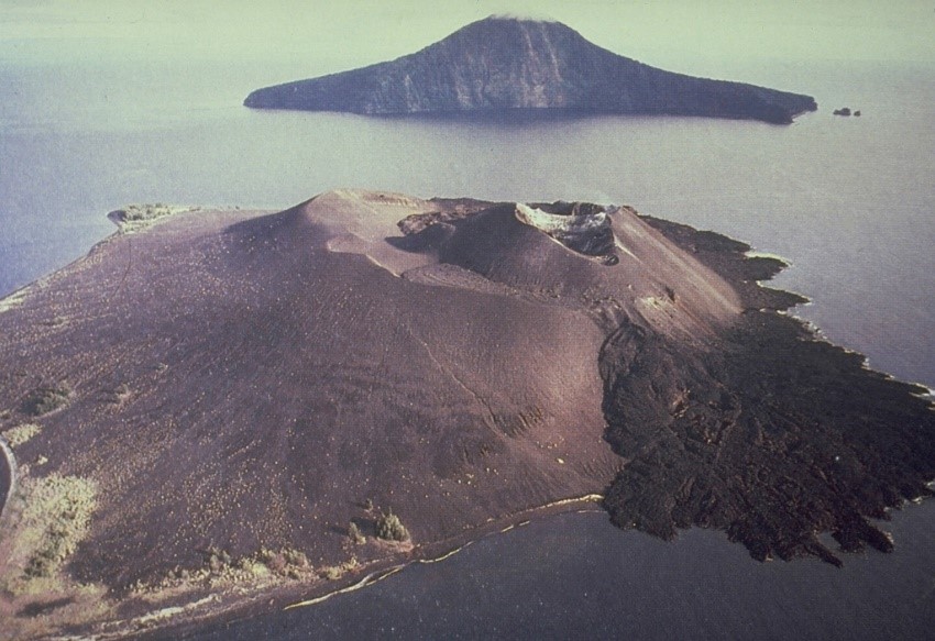
The 1883 eruption destroyed much of Krakatau Island, forming a submarine caldera. Rakata Island in the background is the truncated rim of the 1883 caldera and Anak Krakatau in the foreground is a post-caldera cone that first emerged from the sea in 1929 and has been frequently activity since (Image: Volcanological Survey of Indonesia).
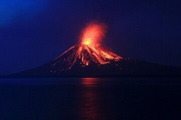
Eruption of Anak Krakatau in December 2018 which triggered onset of deadly tsunami, killing 430 people, and injuring many more. Tsunami stripped vegetation from surrounding coastlines, thus exposing stratigraphy that would help scientists better understand the 1883 eruption and the precursory phases leading up to a large, caldera-forming event (Image: El Ghazali/ National Geographic).
In 2018, a large tsunami triggered by the collapse of Anak Krakatau stripped vegetation from nearby shorelines and thus exposed sequences of the 1883 eruption – arguably the deadliest and most destructive volcanic event recorded in human history.
The Krakatau archipelago is part of the Sunda Arc. Volcanism in this region is a result of the subduction of the Indo-Australian Plate beneath the Eurasian Plate. The eruption of Krakatau volcano on 26 and 27 August 1883 was the culmination of at least four months of unrest (for detailed precursory timeline see Madden-Nadeau et al. 2021). The 1883 eruption is one of the most infamous volcanic disasters, and the first caldera-forming eruption in human history to make headline news around the world thanks to the invention of the first transatlantic cable a few years prior to the eruption, allowing information to be globally distributed quickly – in essence, this eruption was the first ever global media event.
The event caused around 36,000 fatalities, the majority of deaths attributed to the numerous volcanogenic tsunami triggered by pyroclastic density currents (fast-moving currents of hot gas and volcanic matter) entering the sea. Impacts were not localised, in fact shockwaves from the final cataclysmic eruption circumnavigated the globe 7 times and the enormous volume of volcanic aerosols/ dust injected into the stratosphere lowered global air temperatures by 1.2 degrees Celsius. For many months after the eruption, vivid sunsets were observed around the world caused by these aerosols. This was a VEI (Volcanic Explosivity Index) 6 event.
The aim of the study was to integrate the known eruptive progression at Krakatau in 1883, based on historical accounts, with new studies of the stratigraphy, crystal zoning and glass geochemistry.
This study presents field observations from new 1883 eruptive deposit exposures of Krakatau, and has allowed for the stratigraphy of the eruption to be considerably better constrained – petrological tools can offer a unique insight into the architecture of pre-eruptive magma plumbing systems, and the conditions leading up to eruption. This research suggests an alternative model for the magmatic system below Krakatau (at the time of eruption) considering the findings of chemical variations in the stratigraphic sequence, previously unknown. The analysis of the freshly exposed sequences also indicates substantial change in the direction of the pyroclastic density currents during the final eruptive phase in 1883. For further detail on the stratigraphic analysis carried out, see Madden-Nadeau et al. article (link below).
Long-term shifts in eruptive style are poorly understood in general, particularly for caldera systems, as there has not yet been the opportunity to monitor any volcano during the long-term build-up to a caldera-forming eruption. This can create uncertainty in the interpretation of contemporary geophysical data with reference to volcano monitoring. As the study concludes, 'The 1883 eruption of Krakatau provides an example of an event where relatively moderate explosive eruptions may potentially have run-away effects culminating in cataclysmic caldera-collapse several months later.' This is a useful insight for the volcanology community to be aware of for future monitoring of similar volcanoes likely to produce caldera-forming eruptions.
This innovative study provides new evidence for the role that precursory eruptions and amalgamation of shallow crustal magma bodies potentially play in the months leading up to caldera-forming eruptions, such as Krakatau 1883.
- All news about: Krakatau volcano
- Information about: Krakatau volcano
---
Links / Sources:
Links / Sources:
Previous news
Tue, 16 Feb 2021, 09:37
QWA: a new tool for analysing climate response to volcanism
A story of a natural disaster can tell a wider story about the relationship between volcanism and climate change and the associated impact on society. To piece together this story and gain a detailed understanding of it, scientists are now utilising ground-breaking techniques. ... Read all
Tue, 2 Feb 2021, 18:03
Shiveluch – World’s most explosive volcano hosts unique superhydrous magma
Water is a key ingredient for fuelling explosive volcanic eruptions. Water-rich magma contains higher proportions of volatiles (gases), increasing buoyancy and therefore driving the upward movement of the magma to the surface. The increase in gases within the magma also increases the pressure, causing the explosive nature of eruptions with this magmatic composition. ... Read all
Show more


