Volcanic activity worldwide 13 May 2021: Pacaya volcano, Fuego, Semeru, Dukono, Reventador, Kilauea,...
Thu, 13 May 2021, 21:00 21:00 PM | BY: SEVERAL CONTRIBUTORS

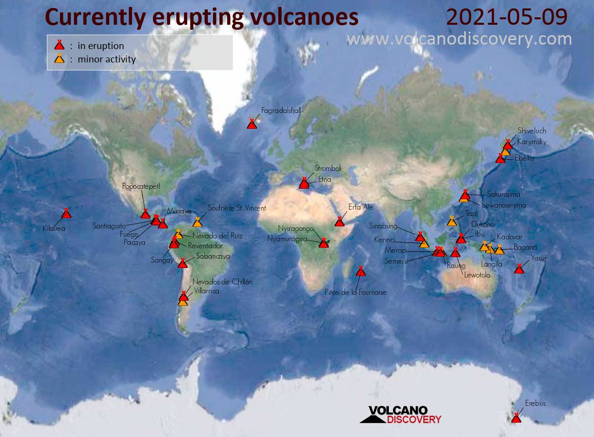
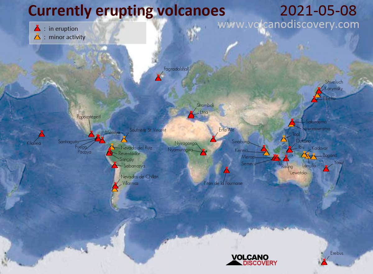
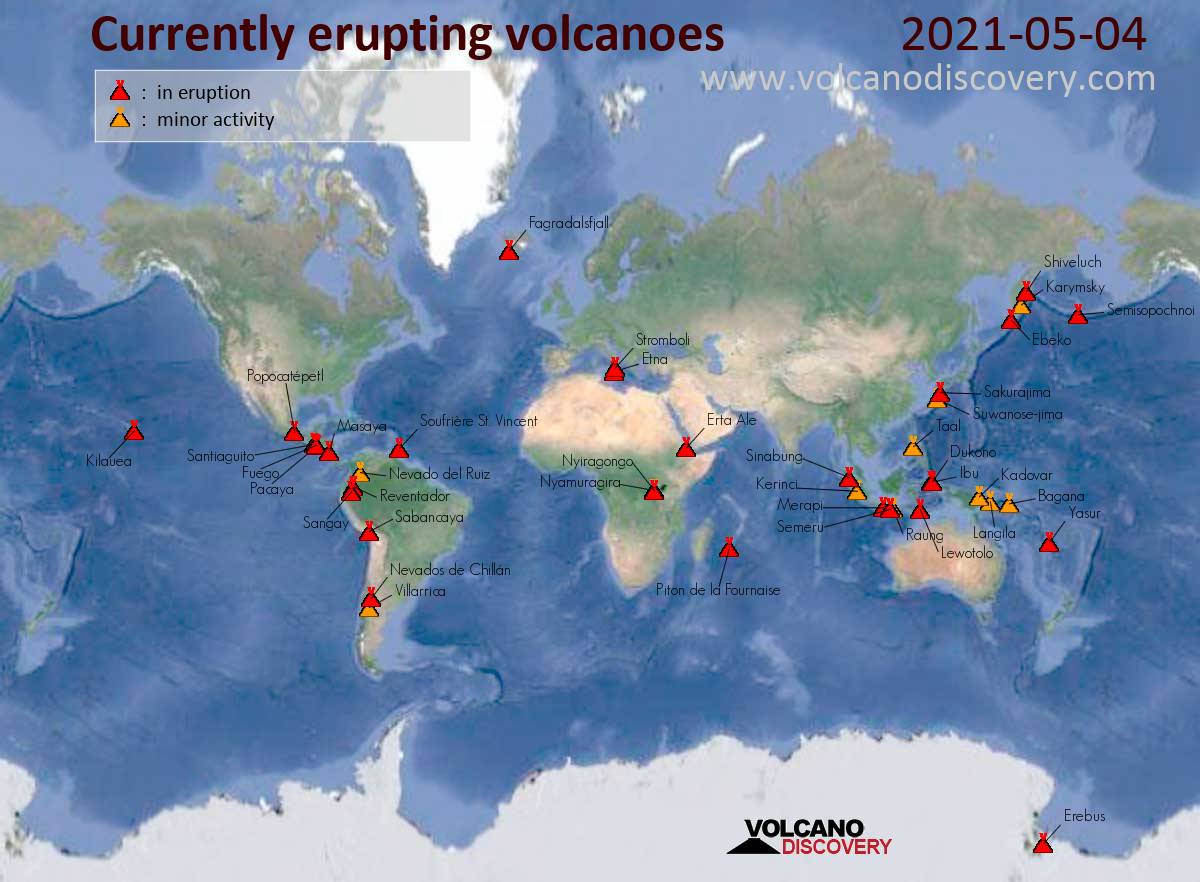
Map of today's active volcanoes
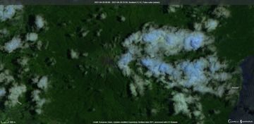
Satellite view of Bulusan volcano (image: Sentinel 2)
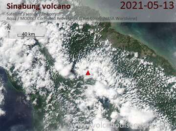
Satellite image of Sinabung volcano on 13 May 2021
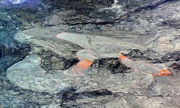
This close-up view of the active western portion of the Halema‘uma‘u lava lake at the summit of Kīlauea was captured on Thursday, May 6 through the lens of a laser rangefinder used by HVO scientists to measure distances to features within the crater. HVO scientists observed that the area immediately surrounding the inlet to the lava lake (above-center) was slightly perched relative to the rest of the active surface, and it was intermittently feeding lava channels to lower-lying parts of the lake (below-center and below-right). The western fissure is out-of-view to the upper-left and the main island in the lava lake is out-of-view to the right. USGS caption & image (color corrected).
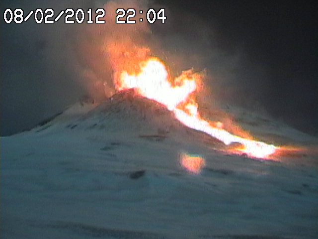
Gas-steam plume from Nevados de Chillán volcano (image: SERNAGEOMIN)
Suwanose-jima (Ryukyu Islands): (13 May) Volcanic Ash Advisory Center Tokyo (VAAC) issued the following report: ERUPTED AT 20210513/0717Z FL060 EXTD E OBS VA DTG:13/0710Z
Bulusan (Luzon Island, Philippines): The Phillippine Institute of Volcanology and Seismology (PHIVOLCS) noted in their latest bulletin that seismic activity at the volcano rapidly increased as about 300 volcano-tectonic earthquakes were detected since 8 May.
Short-term electronic tilt monitoring on the upper slopes recorded a slight ground deformation that began on 6 March.
... [read more]
Sinabung (Sumatra, Indonesia): Explosive activity continues. Volcanic Ash Advisory Center (VAAC) Darwin warned about a volcanic ash plume that rose up to estimated 40000 ft (12200 m) altitude or flight level 400 and is moving at 10 kts in NW direction.
The full report is as follows: HIGH LEVEL ERUPTION TO FL500 OBS VA DTG:13/1935Z to 40000 ft (12200 m)
Semeru (East Java, Indonesia): (13 May) Explosive activity continues. Volcanic Ash Advisory Center (VAAC) Darwin warned about a volcanic ash plume that rose up to estimated 14000 ft (4300 m) altitude or flight level 140 .
The full report is as follows: VA OBS TO FL140 MOV NW. to 14000 ft (4300 m)
Dukono (Halmahera): (13 May) Volcanic Ash Advisory Center Darwin (VAAC) issued the following report: CONTINUOUS VA EMISSIONS TO FL070 EXTD NW EST VA DTG:13/0100Z
Kilauea (Hawai'i): (13 May) The transformation of Kīlauea's lava lake continues after a third consecutive week of crusting, which has reduced and reshaped its open lava surface. Gas emissions dropped to 150 tonnes/day on May 10 according to USGS-HVO, a new low for the eruption that has been ongoing for nearly 5-months, and well within the range of historic non-eruptive background measurements. This suggests that much less lava is erupting, and it could soon stop.
Perhaps due to the effect of lessened gas, the lava lake surface has been cooling and solidifying more quickly on its surface, and rafts of the crust continue to be carried by the liquid beneath. These have continued to stack around the lake margin, as well as the narrow points between cooling islets to form an inner perched pond near the lava inlet, essentially dividing the remaining open lava lake into upper and lower perched ponds. Now, lava rises below the West Vent and enters the inner, highest pond through a submerged inlet, before it cascades through gaps on the far side into the lower perched pond, and ultimately disappears beneath the hardening surface towards the edge of the eruption's big island. While previously the lava was seen to re-emerge along the crater walls through “ooze-up flows”, no such occurrences have been observed in nearly a month.
... [read more]
Great Sitkin (United States, Aleutian Islands): (13 May) The Alaska Volcano Observatory (AVO) reported that identified elevated surface temperatures continue from the beginning of January and detections have increased over the past two months.
Satellite-based measurements of gas emissions reached elevated levels on 10 May.
... [read more]
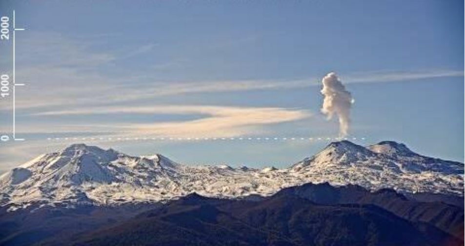
Pacaya (Guatemala): Explosive activity continues. Volcanic Ash Advisory Center (VAAC) Washington warned about a volcanic ash plume that rose up to estimated 11000 ft (3400 m) altitude or flight level 110 .
The full report is as follows: PSBL VA EMS. to 11000 ft (3400 m)
Fuego (Guatemala): Mild explosive activity continues from the volcano. The Volcanic Ash Advisory Center (VAAC) Washington reported intermittent emissions of volcanic ash plumes.
The full report is as follows: sporadic emissions of volcanic ash
Reventador (Ecuador): Explosive activity continues. Volcanic Ash Advisory Center (VAAC) Washington warned about a volcanic ash plume that rose up to estimated 15000 ft (4600 m) altitude or flight level 150 .
The full report is as follows: INTMT VA CLD EMS. to 15000 ft (4600 m)
Sabancaya (Peru): Explosive activity continues. Volcanic Ash Advisory Center (VAAC) Buenos Aires warned about a volcanic ash plume that rose up to estimated 26000 ft (7900 m) altitude or flight level 260 .
The full report is as follows: INTERMITTENT EMISSIONS to 26000 ft (7900 m)
Nevados de Chillán (Central Chile): Volcanic Ash Advisory Center Buenos Aires (VAAC) issued the following report: SPORADIC EMISSIONS
...13 May:
The local observatory SERNAGEOMIN recorded increased sulfur dioxide (SO2) emissions, thermal anomalies and inflation on 27 March, typical signs of an upcoming eruption.
The extruded lava dome, about 66 m tall, has oozed out at a higher flow rate on the W part of the volcano.
... [read more]
Previous news
Wed, 12 May 2021, 21:00
Volcanic activity worldwide 12 May 2021: Pacaya volcano, Fuego, Popocatépetl, Merapi, Semeru, Ibu, ...

Fagradalsfjall (Reykjanes Peninsula, Iceland): The activity of the current eruption site continues at elevated levels during the past two weeks characterized by lava fountaining episodes, about 400-500 m tall, at roughly regular intervals of 7 to 10 minutes. ... Read all
Tue, 11 May 2021, 21:00
Volcanic activity worldwide 11 May 2021: Pacaya volcano, Fuego, Semeru, Dukono, Piton de la Fournais...

Suwanose-jima (Ryukyu Islands): Volcanic Ash Advisory Center Tokyo (VAAC) issued the following report: EXPLODED AT 20210511/1949Z VA CLD UNKNOWN OBS VA DTG:11/1940Z ... Read all
Show more