Date and Time | Mag Depth | Distance | Location | Details | Map |
|---|---|---|---|---|---|
| Apr 22, 09:44 pm (Auckland) | 2.2 34 km | 5.5 km (3.4 mi) to the W | Info | ||
| Saturday, April 20, 2024 GMT (2 quakes) | |||||
| Apr 21, 06:26 am (Auckland) | 2.1 100 km | 24 km (15 mi) to the SW | Info | ||
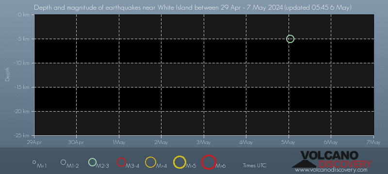
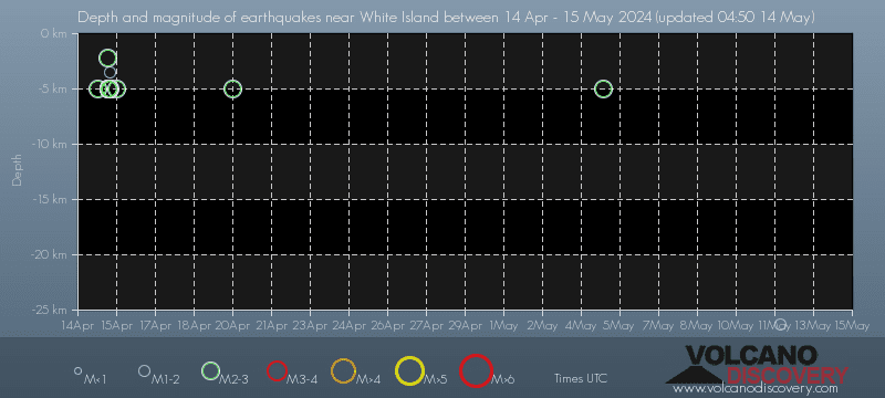
| Apr 20, 05:03 pm (Auckland) | 2.3 5 km | 13 km (7.8 mi) to the SW | Info | ||
| Friday, April 19, 2024 GMT (2 quakes) | |||||
| Apr 20, 01:17 am (Auckland) | 2.3 125 km | 13 km (8 mi) to the NW | Info | ||
| Apr 19, 04:24 pm (Auckland) | 2.2 94 km | 12 km (7.5 mi) to the SW | Info | ||
| Monday, April 15, 2024 GMT (12 quakes) | |||||
| Apr 16, 01:18 am (Auckland) | 2.4 5 km | 19 km (12 mi) to the NE | Info | ||
| Apr 15, 06:53 pm (Auckland) | 1.9 3.5 km | 26 km (16 mi) to the SW | Info | ||
| Apr 15, 06:19 pm (Auckland) | 2.5 5 km | 22 km (13 mi) to the SW | Info | ||
| Apr 15, 05:54 pm (Auckland) | 2.7 5 km | 22 km (14 mi) to the SW | Info | ||
| Apr 15, 05:33 pm (Auckland) | 2.2 5 km | 23 km (14 mi) to the SW | Info | ||
| Apr 15, 05:29 pm (Auckland) | 2.2 5 km | 22 km (14 mi) to the SW | Info | ||
| or | ||
Look up quakes! | ||