SEARCH
| Latest today See all | Mag. 3.4 earthquake Philippine Sea - Indonesia - |
| Strongest today | Mag. 4.1 Kabupaten Way Kanan - Lampung, Indonesia - |
Date and Time | Mag Depth | Nearest Volcano | Location | Details | Map |
|---|---|---|---|---|---|
| May 4, 03:13 am (GMT +8) | 3.4 30 km | 69 km (43 mi) to the NE | Info | ||
| May 3, 11:06 pm (GMT +6) | 4.0 10 km | 114 km (71 mi) to the W | Info | ||
| May 4, 01:02 am (Makassar) | 3.5 10 km | Info | |||
| May 4, 01:00 am (Makassar) | 1.7 10 km | 13 km (8.1 mi) to the S | Info | ||
| May 3, 11:29 pm (GMT +8) | 3.1 113 km | 64 km (40 mi) to the NE | Info | ||
| May 3, 11:08 pm (Makassar) | 2.6 10 km | 2 km (1.2 mi) to the N | Info | ||
| May 3, 10:25 pm (Makassar) | 2.7 10 km | 16 km (9.9 mi) to the S | Info | ||
| May 3, 08:42 pm (Makassar) | 3.6 10 km | Info | |||
| May 3, 08:35 pm (Makassar) | 3.1 10 km | Info | |||
| May 3, 08:23 pm (Makassar) | 3.1 10 km | Info | |||
| May 3, 08:35 pm (Jayapura) | 4.0 10 km | 14 km (8.7 mi) to the NE | Info |
| or | ||
Look up quakes! | ||
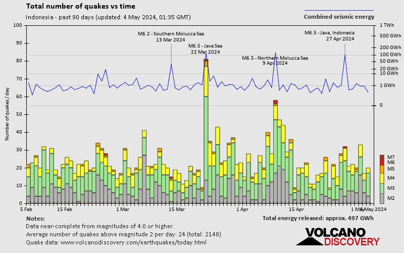
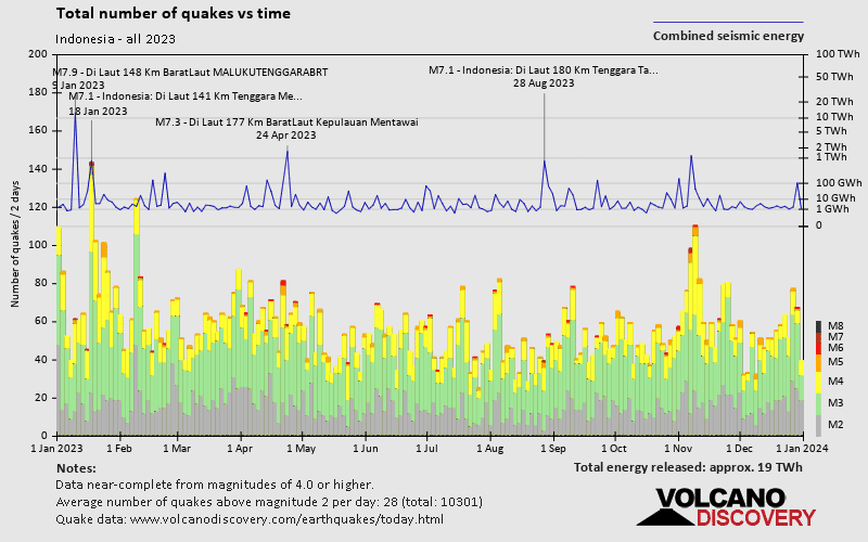
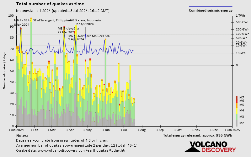
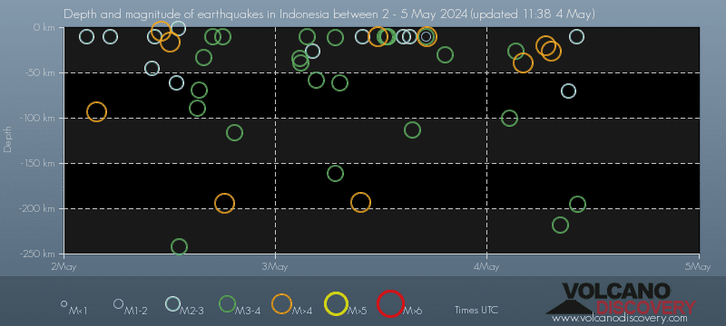
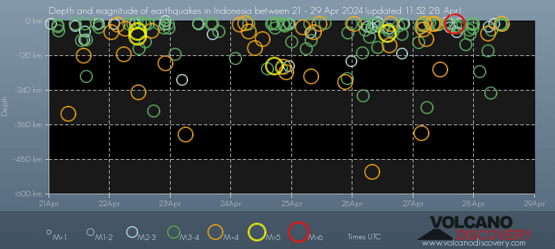
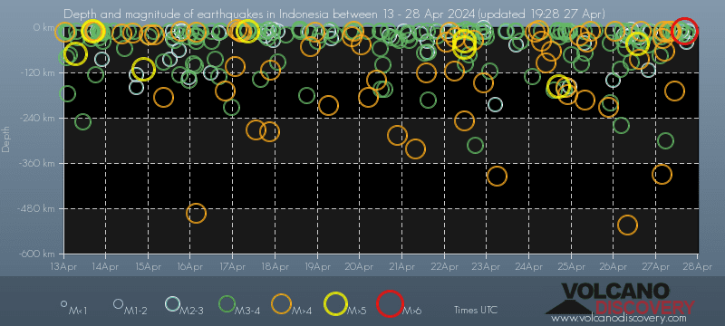
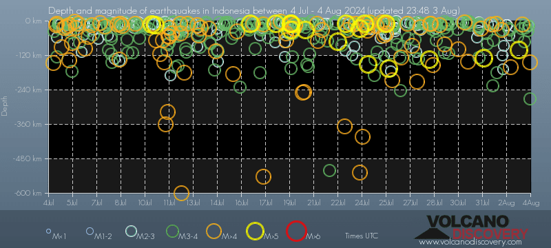
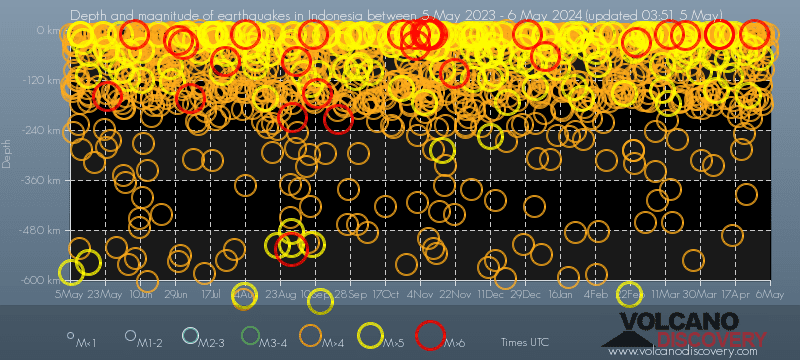
Indonesia has a very high level of seismic activity. Based on data from the past 14 years and our earthquake archive back to 1900, there are about 8,800 quakes on average per year in Indonesia. Indonesia has had at least 2 quakes above magnitude 9 since 1900, which suggests that larger earthquakes of this size occur infrequently, probably on average approximately every 60 to 65 years.
On average, Indonesia has about 6,500 quakes of magnitude 3 or higher per year (Mag 4+: 2,400 quakes per year, Mag 5+: 220 quakes per year, Mag 6+: 17.8 quakes per year).
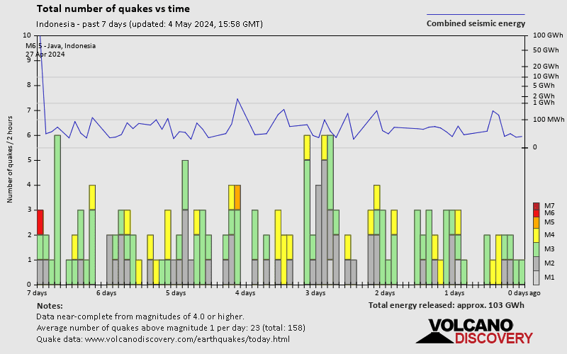
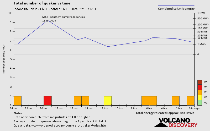
The last earthquake in Indonesia occurred 5 hours ago and had a magnitude of 3.4:
A light magnitude 3.4 earthquake occurred in the Philippine Sea near the coast of ![]() Indonesia in the early morning of Saturday, May 4, 2024 at 3.13 am local time (GMT +8). The quake had a very shallow depth of 30 km (19 mi) and was not felt (or at least not reported so).
Indonesia in the early morning of Saturday, May 4, 2024 at 3.13 am local time (GMT +8). The quake had a very shallow depth of 30 km (19 mi) and was not felt (or at least not reported so).
In the past 24 hours, Indonesia was shaken by 3 quakes of magnitude 4.0 or above, 13 quakes between 3.0 and 4.0, and 4 quakes between 2.0 and 3.0.
The strongest earthquake in Indonesia in the past 24 hours had a magnitude of 4.1 and occurred 14 hours ago:
A moderate magnitude 4.1 earthquake hit 43 km (27 mi) away from Kotabumi, Lampung, ![]() Indonesia, in the afternoon of Friday, May 3, 2024 at 4.40 pm local time (Asia/Jakarta GMT +7). The quake had a moderate depth of 193 km (120 mi) and was not felt (or at least not reported so).
Indonesia, in the afternoon of Friday, May 3, 2024 at 4.40 pm local time (Asia/Jakarta GMT +7). The quake had a moderate depth of 193 km (120 mi) and was not felt (or at least not reported so).
Date and Time | Mag Depth | ###DIST_LABEL### | Location | Details | Map |
|---|