Latest Worldwide >  Timor-Leste > Lautein > Lospalos
SEARCH
Latest Quakes | Top 20 | Report a Quake! | Damaging Quakes | By Country/Region | Near Me | Quake Stats | FAQ | News | Volcanoes | Be Safe


SEARCH
| Latest See all | Mag. 4.2 earthquake Kepulauan Barat Daya - Indonesia - Jan 7, 2024 - |
| Strongest since 2022 | Mag. 6.2 37 km NE of Lospalos - Timor Leste - May 27, 2022 - |
Date and Time | Mag Depth | Nearest Volcano | Location | Details | Map |
|---|---|---|---|---|---|
| Jan 7, 11:16 pm (Jayapura) | 4.2 124 km | 94 km (58 mi) to the NE | Info | ||
| Monday, December 11, 2023 GMT (1 quake) | |||||
| Dec 11, 2023 12:50 pm (GMT +9) | 5.0 57 km | 91 km (57 mi) to the NE | Info | ||
| Saturday, October 21, 2023 GMT (1 quake) | |||||
| Oct 22, 2023 12:48 am (Jayapura) | 4.3 10 km | 57 km (36 mi) to the N | Info | ||
| Sunday, September 17, 2023 GMT (1 quake) | |||||
| Sep 17, 2023 07:56 pm (Jayapura) | 4.4 10 km | 95 km (59 mi) to the E | Info | ||
| Sunday, September 10, 2023 GMT (1 quake) | |||||
| Sep 11, 2023 04:43 am (Jayapura) | 4.1 202 km | 95 km (59 mi) to the NW | Info | ||
| Thursday, August 31, 2023 GMT (1 quake) | |||||
| Sep 1, 2023 01:20 am (GMT +9) | 4.2 101 km | 28 km (17 mi) to the NE | Info | ||
| Saturday, August 19, 2023 GMT (1 quake) | |||||
| Aug 19, 2023 05:34 pm (GMT +9) | 4.4 122 km | 87 km (54 mi) to the W | Info | ||
| Monday, April 17, 2023 GMT (1 quake) | |||||
| Apr 17, 2023 10:04 pm (GMT +8) | 4.5 125 km | 88 km (55 mi) to the N | Info | ||
| Thursday, March 23, 2023 GMT (1 quake) | |||||
| Mar 23, 2023 08:21 pm (Jayapura) | 4.4 190 km | 93 km (58 mi) to the NW | Info | ||
| Thursday, March 16, 2023 GMT (1 quake) | |||||
| Mar 16, 2023 05:41 pm (GMT +8) | 4.3 10 km | 69 km (43 mi) to the SW | Info | ||
| Sunday, January 15, 2023 GMT (1 quake) | |||||
| Jan 16, 2023 12:27 am (Jayapura) | 4.5 104 km | 87 km (54 mi) to the N | Info | ||

| or | ||
Look up quakes! | ||


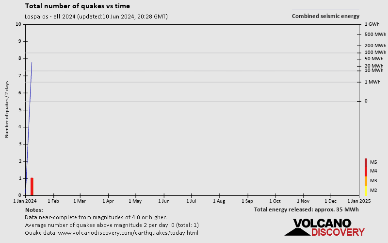
Lospalos has a high level of seismic activity. Based on data from the past 54 years and our earthquake archive back to 1900, there are about 8.7 quakes on average per year in or near Lospalos, Lautein, Timor-Leste. Lospalos has had at least 2 quakes above magnitude 7 since 1900, which suggests that larger earthquakes of this size occur infrequently, probably on average approximately every 60 to 65 years.
The last earthquake in Lospalos occurred 18 weeks ago and had a magnitude of 4.2:
A moderate magnitude 4.2 earthquake occurred in the Banda Sea near Pulau Romang island, Indonesia, late in the evening of Sunday, Jan 7, 2024 at 11.16 pm local time (Asia/Jayapura GMT +9). The quake had a moderate depth of 124 km (77 mi) and was not felt (or at least not reported so).
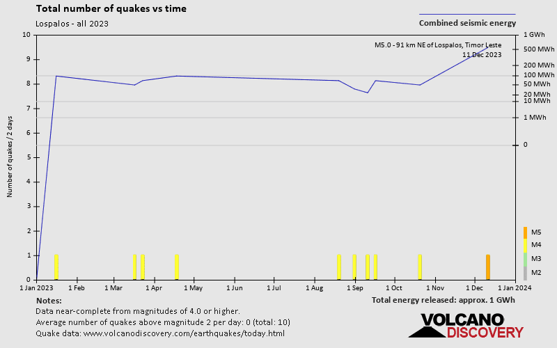
Since 2022, Lospalos has been shaken by 1 quake of magnitude 6.2, 2 quakes between 5.0 and 6.0, 19 quakes between 4.0 and 5.0, and 1 quake of magnitude.
The strongest earthquake in Lospalos since 2022 had a magnitude of 6.2 and occurred 1 year 50 weeks ago:
A very strong magnitude 6.2 earthquake occurred in the Banda Sea near the coast of Maluku, ![]() Indonesia, in the morning of Friday, May 27, 2022 at 11.36 am local time (GMT +9). The quake had a shallow depth of 49 km (30 mi) and was felt over a large region.
Indonesia, in the morning of Friday, May 27, 2022 at 11.36 am local time (GMT +9). The quake had a shallow depth of 49 km (30 mi) and was felt over a large region.
Date and Time | Mag Depth | ###DIST_LABEL### | Location | Details | Map |
|---|