Latest Worldwide >  Philippines > Eastern Visayas > Tacloban City
SEARCH
Latest Quakes | Top 20 | Report a Quake! | Damaging Quakes | By Country/Region | Near Me | Quake Stats | FAQ | News | Volcanoes | Be Safe


SEARCH
| Latest See all | Mag. 1.5 earthquake Philippines: 029 km N 75° W of Homonhon Island (Guiuan) (Eastern Samar) - |
| Strongest past 30 days | Mag. 5.7 28 km SSW of Balangiga - Philippines - May 3, 2024 - |
Date and Time | Mag Depth | Nearest Volcano | Location | Details | Map |
|---|---|---|---|---|---|
| May 13, 08:10 pm (Manila) | 1.5 34 km | 70 km (43 mi) to the SE | Info | ||
| May 13, 07:20 pm (GMT +8) | 2.1 20 km | 57 km (35 mi) to the SE | Info | ||
| May 13, 03:47 pm (GMT +8) | 2.2 4 km | 54 km (34 mi) to the SE | Info | ||
| Sunday, May 12, 2024 GMT (2 quakes) | |||||
| May 13, 12:40 am (Manila) | 1.7 1 km | 47 km (29 mi) to the SE | Info | ||
| May 12, 06:29 pm (GMT +8) | 2.4 1 km | 53 km (33 mi) to the SE | Info | ||
| Saturday, May 11, 2024 GMT (5 quakes) | |||||
| May 12, 07:56 am (GMT +8) | 3.1 1 km | 55 km (34 mi) to the SE | Info | ||
| May 12, 07:28 am (Manila) | 2.5 1 km | 53 km (33 mi) to the SE | Info | ||
| May 12, 07:19 am (GMT +8) | 3.5 1 km | 57 km (35 mi) to the SE | Info | ||
| May 12, 07:14 am (GMT +8) | 3.4 2 km | 56 km (35 mi) to the SE | Info | ||
| May 11, 09:29 pm (Manila) | 3.4 11 km | 56 km (35 mi) to the SE | Info | ||
| Thursday, May 9, 2024 GMT (6 quakes) | |||||
| May 10, 03:30 am (GMT +8) | 2.1 8 km | 58 km (36 mi) to the SE | Info | ||

| or | ||
Look up quakes! | ||
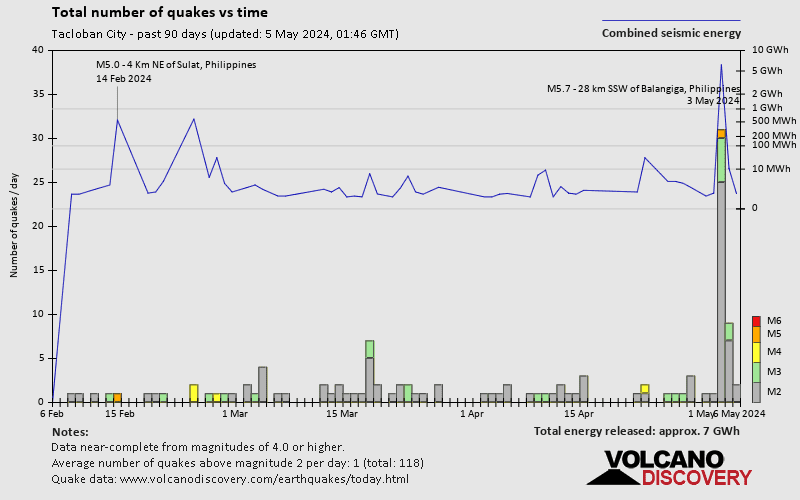

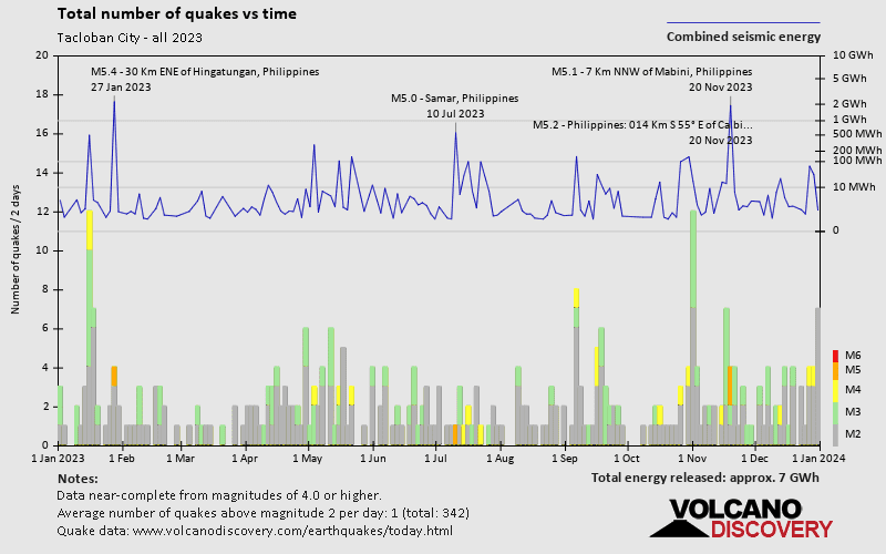
Tacloban City has a very high level of seismic activity. Based on data from the past 54 years and our earthquake archive back to 1900, there are about 422 quakes on average per year in or near Tacloban City, Eastern Visayas, Philippines. Tacloban City has had at least 2 quakes above magnitude 7 since 1900, which suggests that larger earthquakes of this size occur infrequently, probably on average approximately every 60 to 65 years.
The last earthquake in Tacloban City occurred 1 hour and 46 minutes ago and had a magnitude of 1.5:
A light magnitude 1.5 earthquake occurred in the Philippine Sea near Homonhon Island island, Philippines, in the evening of Monday, May 13, 2024 at 8.10 pm local time (Asia/Manila GMT +8). The quake had a very shallow depth of 34 km (21 mi) and was too small to be felt by people.
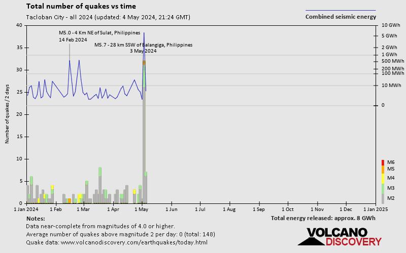
In the past 30 days, Tacloban City has been shaken by 2 quakes of magnitude 5.0 or above, 1 quake of magnitude , 31 quakes between 3.0 and 4.0, and 81 quakes between 2.0 and 3.0. There have been also 16 quakes below magnitude 2.0 which people don't normally feel.
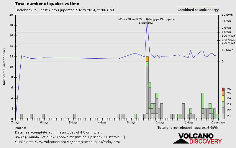
The strongest earthquake in Tacloban City in the past 30 days had a magnitude of 5.7 and occurred 10 days ago:
A strong magnitude 5.7 earthquake occurred in the Philippine Sea near Homonhon Island island, Philippines, in the late afternoon of Friday, May 3, 2024 at 6.16 pm local time (GMT +8). The quake had a very shallow depth of 7.9 km (4.9 mi) and was felt over a large region.
Date and Time | Mag Depth | ###DIST_LABEL### | Location | Details | Map |
|---|