Contact | RSS | EN | DE | EL | ES | FR | IT | RU

Popocatépetl Volcano Volcanic Ash Advisory: VA CLD RPRTD 26/1134Z to 24000 ft (7300 m)

Sun, 26 Sep 2021, 12:15 | BY: VN
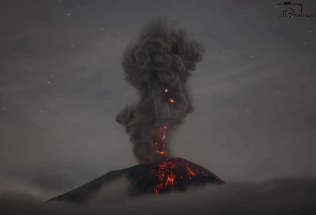
Explosive activity continues. Volcanic Ash Advisory Center (VAAC) Washington warned about a volcanic ash plume that rose up to estimated 24000 ft (7300 m) altitude or flight level 240 .
The full report is as follows:

FVXX22 at 12:06 UTC, 26/09/21 from KNES
VA ADVISORY
DTG: 20210926/1204Z

VAAC: WASHINGTON

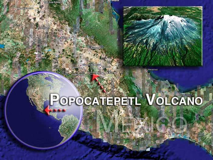
VOLCANO: POPOCATEPETL 341090
PSN: N1901 W09837

AREA: MEXICO

SUMMIT ELEV: 17802 FT [5426 M]

ADVISORY NR: 2021/578

INFO SOURCE: GOES-16. MEXICO CITY MWO. WEBCAM.
NWP MODELS.

ERUPTION DETAILS: VA CLD RPRTD 26/1134Z

OBS VA DTG: 26/1136Z

OBS VA CLD: SFC/FL240 N1905 W09846 - N1902 W09837
- N1901 W09840 - N1859 W09846 - N1905 W09846 MOV
W 15KT

FCST VA CLD +6HR: 26/1730Z SFC/FL240 N1918 W09935
- N1902 W09837 - N1900 W09840 - N1901 W09935 -
N1918 W09935

FCST VA CLD +12HR: 26/2330Z SFC/FL240 N1919
W09935 - N1902 W09837 - N1901 W09840 - N1900
W09936 - N1919 W09935

FCST VA CLD +18HR: 27/0530Z NO VA EXP

RMK: MMEX REPORT RECEIVED OF VA CLD AND SEEN IN
STLT MOVG W OF SUMMIT APPRX 10NM. VA FCST TO MOV
GENERALLY W THRU T+12 HRS BASED ON NWP MDLS.
...COVERDALE

NXT ADVISORY: WILL BE ISSUED BY 20210926/1800Z

Previous news

Show more

Background:

Volcán Popocatépetl, whose name is the Aztec word for smoking mountain, towers to 5426 m 70 km SE of Mexico City to form North America's 2nd-highest volcano.  The glacier-clad stratovolcano contains a steep-walled, 250-450 m deep crater.  The generally symmetrical volcano is modified by the sharp-peaked Ventorrillo on the NW, a remnant of an earlier volcano. 
At least three previous major cones were destroyed by gravitational failure during the Pleistocene, producing massive debris-avalanche deposits covering broad areas south of the volcano.  The modern volcano was constructed to the south of the late-Pleistocene to Holocene El Fraile cone.  Three major plinian eruptions, the most recent of which took place about 800 AD, have occurred from Popocatépetl since the mid Holocene, accompanied by pyroclastic flows and voluminous lahars that swept basins below the volcano.  Frequent historical eruptions, first recorded in Aztec codices, have occurred since precolumbian time.


---


Source: GVP, Smithsonian Institution - Popocatepetl information


Satellite images of Popocatepetl volcano (c)Google Earth View
Stratovolcano 5426 m / 17,802 ft
Central Mexico, 19.02°N / -98.62°W
Current status: erupting (4 out of 5) Popocatépetl volcano eruptions:
1345-47, 1354, 1363(?), 1488, 1504, 1509(?), 1512, 1518, 1519-23(?), 1528, 1530, 1539-40, 1542, 1548, 1571, 1580, 1590, 1592-94, 1642, 1663-65, 1666-67, 1697, 1720, 1802-04, 1827(?), 1834(?), 1852(?), 1919-22, 1923-24, 1925-27(?), 1933, 1942-43, 1947, 1994-95, 1996-2003, 2004-ongoing
Typical eruption style
Dominantly explosive, construction of lava domes. Plinian eruptions at intervals of several centuries or few thousands of years, vulcanian and strombolian activity in intermittent phases.
Popocatépetl Volcano Tours
tour to see the ongoing eruption of Mexico's most active volcano
6 days / 5 nights - Easy
Price 1650 €
no scheduled dates at present
Try our free app!
Volcanoes & Earthquakes - new app for Android
Android | iOS version

More on VolcanoDiscovery

Why is there advertising on this site?

Support us - Help us upgrade our services!

We truly love working to bring you the latest volcano and earthquake data from around the world. Maintaining our website and our free apps does require, however, considerable time and resources.
We need financing to increase hard- and software capacity as well as support our editor team. We're aiming to achieve uninterrupted service wherever an earthquake or volcano eruption unfolds, and your donations can make it happen! Every donation will be highly appreciated. If you find the information useful and would like to support our team in integrating further features, write great content, and in upgrading our soft- and hardware, please make a donation (PayPal or Online credit card payment).

Planned features:Thanks to your past donations, these features have been added recently:
Download and Upgrade the Volcanoes & Earthquakes app to get one of the fastest seismic and volcano alerts online:
Android | IOS
Thank you!
Sources: VolcanoDiscovery / VolcanoAdventures and other sources as noted.
Use of material: Most text and images on our websites are owned by us. Re-use is generally not permitted without authorization. Contact us for licensing rights.
Volcanoes & Earthquakes
VolcanoDiscovery Home
Volcanoes | Earthquakes | Photos | Volcano News | App
Adventure & Study Travel
Tours to Volcanoes and Volcanic Areas: walking tours, photo tours, study tours
Tours & Dates | FAQ | About us
Get our newsletter!
Company info
Contact | Legal info | Terms & conditions
Follow us
Follow us on facebook Follow us on Instagram Follow us on Twitter Visit our Youtube channel
EN | DE | EL | ES | FR | IT | RU
VolcanoDiscovery GmbH, Germany, Reg. nr.: HRB 103744, EU Tax Id: DE 297 465 123 owned and created by
Dr. Tom Pfeiffer, volcanologist, volcano photographer, tour organizer member of
IAVCEI
IAVCEI
Vulkanologische Gesellschaft
Volcanological Society
Ecotourism Greece
Ecotourism Greece
RUV insurance
Insured by R+V
VolcanoDiscovery © 2004- All Rights Reserved | Privacy - Cookie Settings