Volcanic activity worldwide 21 Sep 2021: Etna volcano, Fuego, Reventador, Sangay, Katmai, La Palma, ...
Tue, 21 Sep 2021, 21:00 21:00 PM | BY: SEVERAL CONTRIBUTORS

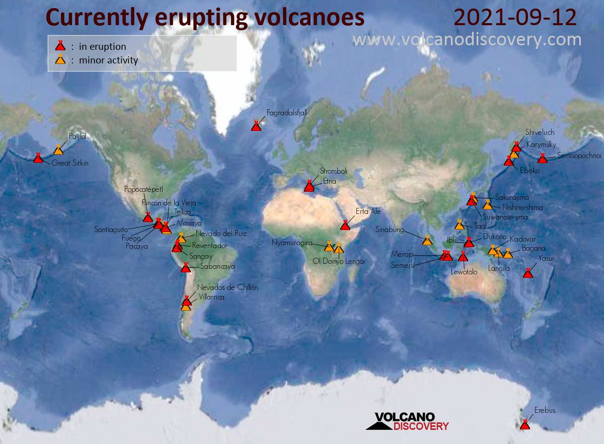
Map of today's active volcanoes
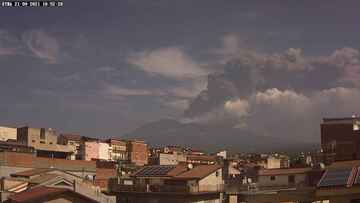
Ash column from Etna's paroxysm this morning (image: Radio touring webcam)
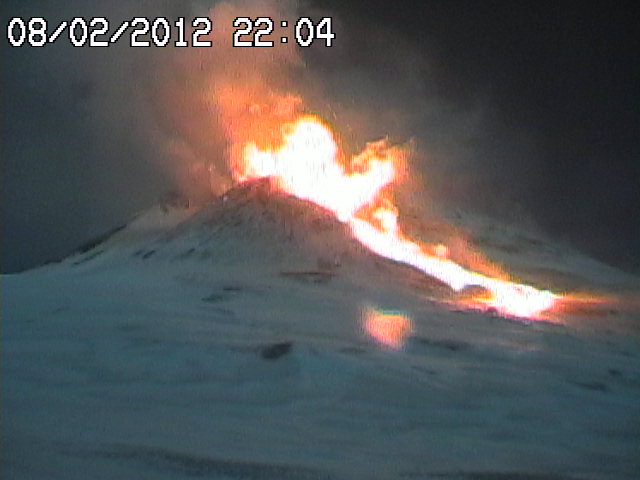
The lava flows approaching Todoque last night (image: Michael Risch)

Estimated extent of lava flows as of this morning (image: Udri @UdriGeo / twitter)

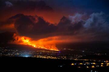
Lava fountain from the new vent on La Palma this morning (image: TV Canaria / El Mundo live stream)
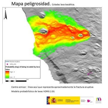
Lava flow hazard map for La Palma eruption (image: IGN Canary Islands)
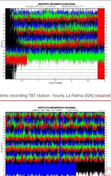
Seismic signal of the 3.8 quake at 9.32 p.m. on La Palma

TROPOMI SO2 product showing a robust gas plume traveling south-southeast from Semisopochnoi volcano on 19 September (image: AVO)
At 4.20 a.m. local time, volcanic tremor suddenly began to rise sharply. At 8.15 a.m., ash emissions were seen from the New SE crater, and strombolian explosions started a7 8.55 a.m., generating an ash plume that quickly rose to 4,500 m altitude.
... [read more]
La Palma (Canary Islands (Spain)): The eruption continues with lava fountains from the new vent that opened last night and continuing lava flow emission. During the past hours, volcanic tremor has increased significantly, suggesting that output rate has increased or something else is changing. It will probably become clearer in the next hours what is happening.
During the past 24 hours, activity has been relatively stable. The advance of the fronts have slowed down and they remained at approx. 1 km from the shore, due to the fact that the flow fronts are now in less steep terrain, which causes them to widen significantly as well rather than progress. However, they are now slowly advancing through the town of Todoque, destroying it.
... [read more]
...21 Sep:
In the last hours, the lava flows have been approaching the urban centers of Todoque town, part of Los Llanos de Aridane, located southwest of area known as Isla Bonita. Authorities have closed the roads LP-211 Todoque, LP-212 Tacande, LP-213 Puerto Naos, LP-215 Tazacorte-La Laguna and LP-2 at the height of Tajuya, in addition to the La Cumbre highway, LP-3, which is subject to restrictions.
The attached map shows the approximate extent of the lava flows as of this morning (link to original map on google).
...21 Sep:
The eruption continues with no major changes over night. Fortunately, the advance of the active lava flows has decreased and not yet reached the sea it had been feared it might have done so by last evening.
This is giving valuable time to evacuate houses and other buildings in its path, for example the Ermita de San Pío X church complex in Todoque.
Lava fountaining continues from the new vent that opened yesterday evening, and a cinder cone is already growing around it. The rate of deformation of the ground seems to slowly decrease, which might be a sign that the eruption is stabilizing. In addition, earthquake activity has decreased.
...21 Sep:
A spectacular video footage of the opening new eruptive fissure has been tweeted by local observers.
The eruptive fissure opened around 9 p.m. local time in the area of Tacande, in the municipality of El Paso.
#ÚltimaHora | Surge nueva boca en la erupción en #LaPalma Se encuentra más abajo de la principal y hacia el norte. Sería la novena boca que tiene ya el #VolcandeLaPalma Imágenes tomadas por los vecinos pic.twitter.com/d7H61RNiGq
— RTVC (@RTVCes) September 20, 2021
We would like to show you embedded content from X/Twitter. If you like to see this content, please make sure you agree with the privacy policy of X/Twitter and click the button:
View embedded content from X/Twitter
View embedded content from X/Twitter
...21 Sep:
The Instituto Geográfico Nacional Canary Islands (IGN) published a simulation of lava flows at the current eruption site where are expected to travel including a possibility of affected areas.
One the main impact of the eruption is risk from ash and gas, e.g. inhalation close to the spring site.
...20 Sep:
As suspected as a possible scenario earlier, the eruption continues to evolve as a new fissure opened around 9 p.m. local time in the area of Tacande, in the municipality of El Paso. It seems to be approx. 1 km west of the original vents.
The opening of the new eruptive fissure was followed by a relatively strong magnitude 3.8 quake at 9.32 p.m., widely felt by people in Los Llanos de Aridane, Breña Baja, Tazacorte, El Paso, Breña Alta, Fuenca.
Suwanose-jima (Ryukyu Islands): Explosive activity continues. Volcanic Ash Advisory Center (VAAC) Tokyo warned about a volcanic ash plume that rose up to estimated 12000 ft (3700 m) altitude or flight level 120 and is moving at 10 kts in SE direction.
The full report is as follows: EXPLODED AT 20210921/1214Z FL120 EXTD S OBS VA DTG:21/1220Z to 12000 ft (3700 m)
Katmai (Alaska Peninsula, USA): Volcanic Ash Advisory Center Washington (VAAC) issued the following report: NOT PROVIDED
Semisopochnoi (United States, Aleutian Islands): Explosive activity continues. Volcanic Ash Advisory Center (VAAC) Anchorage warned about a volcanic ash plume that rose up to estimated 12000 ft (3700 m) altitude or flight level 120 and is moving at 15 kts in W direction.
The full report is as follows: PERIODIC VA ERUPTIONS CONTINUE to 12000 ft (3700 m)
...21 Sep:
The activity at the volcano continues to be elevated.
The Alaska Volcano Observatory (AVO) reported that ash emissions from the ongoing explosive eruption slowed down shortly after as the alert level for the volcano was raised to "red" a few hours ago.
... [read more]
Fuego (Guatemala): Explosive activity continues. Volcanic Ash Advisory Center (VAAC) Washington warned about a volcanic ash plume that rose up to estimated 15000 ft (4600 m) altitude or flight level 150 .
The full report is as follows: NEW VA OSBD to 15000 ft (4600 m)
Sangay (Ecuador): (21 Sep) Explosive activity continues. Volcanic Ash Advisory Center (VAAC) Washington warned about a volcanic ash plume that rose up to estimated 22000 ft (6700 m) altitude or flight level 220 .
The full report is as follows: PSBL CONTG VA EMS. to 22000 ft (6700 m)
Reventador (Ecuador): Explosive activity continues. Volcanic Ash Advisory Center (VAAC) Washington warned about a volcanic ash plume that rose up to estimated 17000 ft (5200 m) altitude or flight level 170 .
The full report is as follows: VA EMS CONTINUE to 17000 ft (5200 m)
Sabancaya (Peru): Explosive activity continues. Volcanic Ash Advisory Center (VAAC) Buenos Aires warned about a volcanic ash plume that rose up to estimated 26000 ft (7900 m) altitude or flight level 260 .
The full report is as follows: INTERMITTENT EMISSIONS to 26000 ft (7900 m)
Previous news
Mon, 20 Sep 2021, 21:00
Volcanic activity worldwide 20 Sep 2021: Fuego volcano, Semeru, Reventador, Sangay, La Palma, Sabanc...

La Palma (Canary Islands (Spain)): Explosive activity continues. Volcanic Ash Advisory Center (VAAC) Toulouse warned about a volcanic ash plume that rose up to estimated 15000 ft (4600 m) altitude or flight level 150 and is moving at 10 kts in S direction. ... Read all
Sun, 19 Sep 2021, 21:00
Volcanic activity worldwide 19 Sep 2021: Fuego volcano, Karymsky, Reventador, La Palma, Sakurajima, ...

La Palma (Canary Islands (Spain)): More and more details are emerging from multiple media covering the eruption in great detail. At 4:33 p.m., a second fissure opened, about 100 meters above the first one that opened at 3.15 p.m. ... Read all
Show more