Volcano earthquake report for Friday, 10 Aug 2018
Fri, 10 Aug 2018, 23:50 | BY: EARTHQUAKEMONITOR

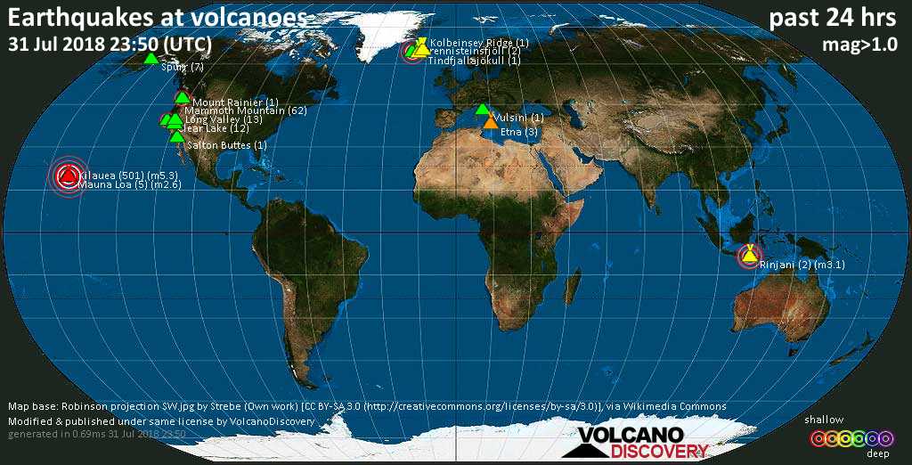
World map showing volcanoes with shallow (less than 20 km) earthquakes within 20 km radius during the past 24 hours on 10 Aug 2018 Number in brackets indicate nr of quakes.
Kilauea (7 quakes between mag 1.7-2.3), Long Valley (19 quakes between mag 0.2-1.4), Martin (1 quake mag 2.0), Mount Rainier (1 quake mag 1.4), Okataina (Tarawera) (1 quake mag 2.4), Reporoa (1 quake mag 1.5), Reykjanes (2 quakes between mag 1.0-1.3), Taupo (1 quake mag 1.7), Tjörnes Fracture Zone (1 quake mag 1.0), Torfajökull (4 quakes between mag 0.1-1.3), Ubehebe Craters (1 quake mag 1.4), Öraefajökull (19 quakes between mag 0.1-1.1) (updated 23h50)
Note: Earthquakes within 20 km from and at depths less than 20 km under active volcanoes are reported. The list is not complete because many volcanoes are not monitored and/or seismic data in high resolution is not available publicly.
Volcanoes with recent earthquakes above magnitude 2 or more than 10 quakes are listed below:
Clear Lake volcano (California): 11 earthquakes up to magnitude 1.8
Possible earthquake swarm: 11 earthquakes occurred near (under) the volcano during 21 hours, the last being recorded quake 2 hours ago. Hypocenter depths ranged between 4.9 and 0.6 km.Earthquake details: (only 5 largest)
M 1.8 quake: 5km NW of The Geysers, CA on Fri, 10 Aug 14h15 (18 km S)
M 1.1 quake: 6km W of Cobb, CA on Fri, 10 Aug 16h22 (15 km S)
M 1.0 quake: 7km NW of The Geysers, CA on Fri, 10 Aug 02h58 (16 km S)
M 0.9 quake: 7km NW of The Geysers, CA on Fri, 10 Aug 03h59 (16 km S)
M 0.9 quake: 6km NW of The Geysers, CA on Fri, 10 Aug 01h25 (16 km S)
All earthquakes at Clear Lake
Goat Rocks volcano (Washington): magnitude 2.5 earthquake
A magnitude 2.5 earthquake occurred at the volcano 6 hours ago. The quake, which might be volcanic in origin, was located at a depth of 4.0 km depth at 5 km distance NNE from the volcano.Earthquake details:
M 2.5 quake: WASHINGTON on Fri, 10 Aug 18h00 (5 km NNE)
All earthquakes at Goat Rocks
Kilauea volcano (Hawai'i (Big Island)): 7 earthquakes up to magnitude 2.3
7 earthquakes occurred near (under) the volcano during 16 hours, the last being recorded quake 6 hours ago. Hypocenter depths ranged between 8.0 and 0.0 km.Earthquake details: (only 5 largest)
M 2.3 quake: ISLAND OF HAWAII, HAWAII on Fri, 10 Aug 13h08 (16 km SW)
M 2.2 quake: ISLAND OF HAWAII, HAWAII on Fri, 10 Aug 04h46 (4 km SSW)
M 2.1 quake: ISLAND OF HAWAII, HAWAII on Fri, 10 Aug 01h19 (7 km SW)
M 2.0 quake: ISLAND OF HAWAII, HAWAII on Fri, 10 Aug 04h35 (4 km S)
M 1.9 quake: 8km WSW of Volcano, Hawaii on Fri, 10 Aug 17h47 (3 km SE)
All earthquakes at Kilauea
Long Valley volcano (California): 19 earthquakes up to magnitude 1.4
Possible earthquake swarm: 19 earthquakes occurred near (under) the volcano during 16 hours, the last being recorded quake 8 hours ago. Hypocenter depths ranged between 5.7 and 0.8 km.Earthquake details: (only 5 largest)
M 1.4 quake: 7km ENE of Mammoth Lakes, CA on Fri, 10 Aug 02h39 (6 km SE)
M 1.3 quake: 6km ENE of Mammoth Lakes, CA on Fri, 10 Aug 03h09 (6 km SE)
M 1.3 quake: 7km ENE of Mammoth Lakes, CA on Fri, 10 Aug 03h14 (6 km SE)
M 1.1 quake: 6km ENE of Mammoth Lakes, CA on Fri, 10 Aug 03h10 (6 km SE)
M 1.1 quake: 7km ENE of Mammoth Lakes, CA on Fri, 10 Aug 02h44 (6 km SE)
All earthquakes at Long Valley
Okataina (Tarawera) volcano (New Zealand): magnitude 2.4 earthquake
A magnitude 2.4 earthquake occurred at the volcano 7 hours ago. The quake, which might be volcanic in origin, was located at a depth of 7.5 km depth at 16 km distance W from the volcano.Earthquake details:
M 2.4 quake: New Zealand on Fri, 10 Aug 17h17 (16 km W)
All earthquakes at Okataina (Tarawera)
Öraefajökull volcano (Iceland): 19 earthquakes up to magnitude 1.1
Possible earthquake swarm: 19 earthquakes occurred near (under) the volcano during 20 hours, the last being recorded quake 2 hours ago. Hypocenter depths ranged between 5.7 and 2.2 km.Earthquake details: (only 5 largest)
M 1.1 quake: 0.7 km ESE of Hvannadalshnjúkur on Fri, 10 Aug 12h53 (2 km NE)
M 1.0 quake: 1.0 km SSE of Hvannadalshnjúkur on Fri, 10 Aug 12h47 (1 km ENE)
M 0.9 quake: 1.5 km SSE of Hvannadalshnjúkur on Fri, 10 Aug 20h41 (1 km E)
M 0.8 quake: 1.2 km SSE of Hvannadalshnjúkur on Fri, 10 Aug 13h06 (1 km ENE)
M 0.7 quake: 0.8 km SE of Hvannadalshnjúkur on Fri, 10 Aug 12h53 (1 km NE)
All earthquakes at Öraefajökull
Previous news
Thu, 9 Aug 2018, 23:50
Volcano earthquake report for Thursday, 9 Aug 2018
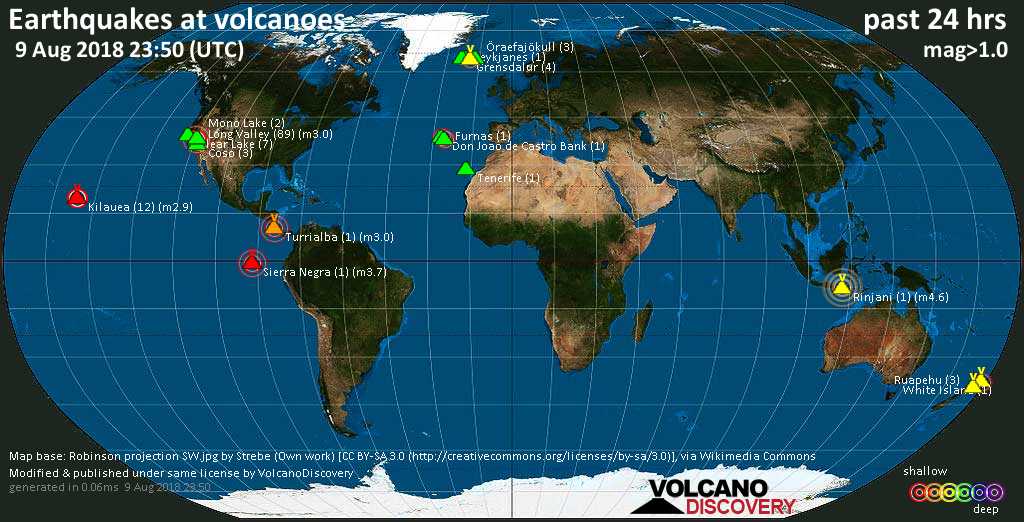
Quakes detected near: Clear Lake (7 quakes between mag 0.3-1.4), Coso (3 quakes between mag 0.8-1.4), Don Joao de Castro Bank (1 quake mag 2.4), Furnas (1 quake mag 2.0), Grensdalur (4 quakes between mag 0.2-1.1), Katla (39 quakes between mag 0.1-2.0) ... Read all
Wed, 8 Aug 2018, 23:50
Volcano earthquake report for Wednesday, 8 Aug 2018
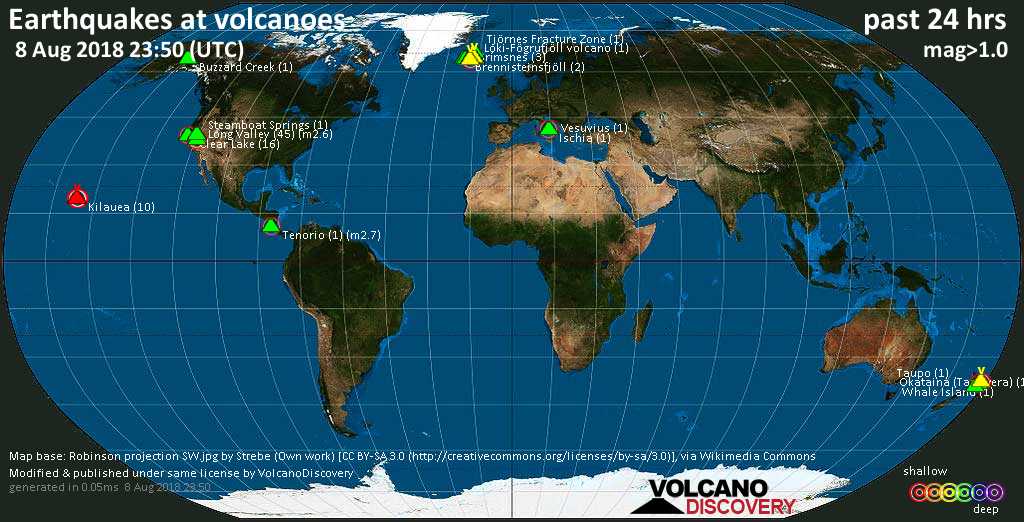
Quakes detected near: Brennisteinsfjöll (2 quakes between mag 0.9-1.4), Buzzard Creek (1 quake mag 1.6), Clear Lake (16 quakes between mag 0.4-2.1), Grímsnes (3 quakes between mag 0.3-1.2), Grímsvötn (3 quakes between mag 1.0-1.4), Ischia (1 quake mag 2.5) ... Read all
Show more