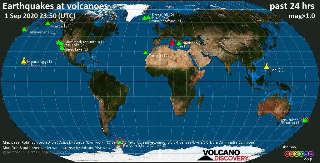
Volcano earthquake report for Thursday, 3 Sep 2020
Thu, 3 Sep 2020, 23:50 | BY: EARTHQUAKEMONITOR

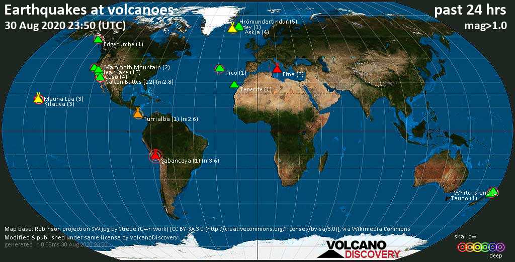
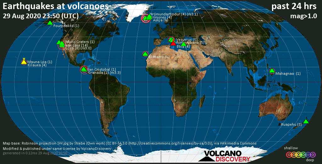
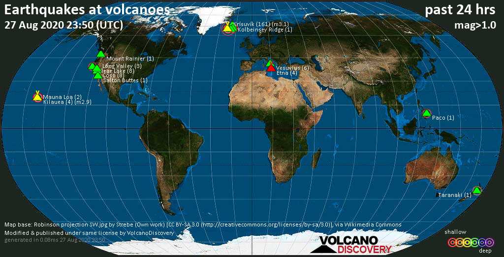
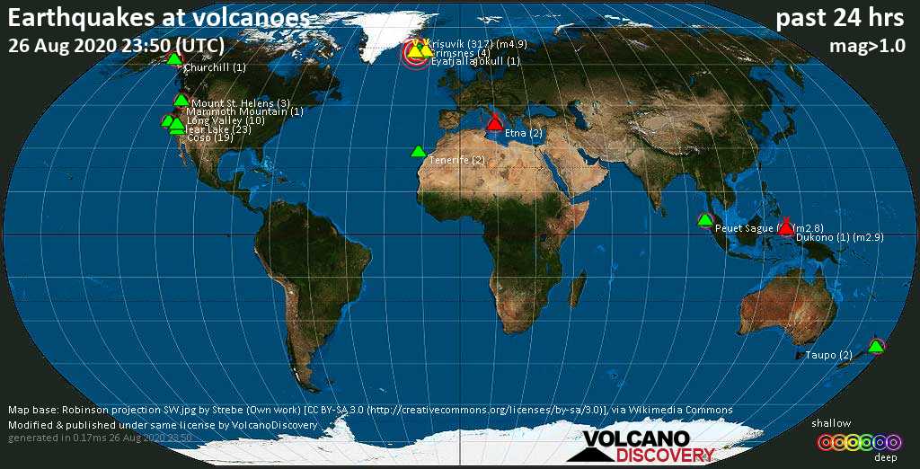
World map showing volcanoes with shallow (less than 20 km) earthquakes within 20 km radius during the past 24 hours on 3 Sep 2020 Number in brackets indicate nr of quakes.
Eyafjallajökull (2 quakes between mag 1.3-1.9), Gareloi (1 quake mag 1.4), Herdubreid (12 quakes between mag 0.1-1.5), Kalatungan (1 quake mag 2.6), Katla (11 quakes between mag 0.3-3.1), Kilauea (2 quakes between mag 1.8-2.5), Krísuvík (36 quakes between mag 0.1-1.6), Kverkfjöll (1 quake mag 1.2), Long Valley (5 quakes between mag 0.3-1.2), Mono Lake (1 quake mag 1.5), Pavlof Sister (1 quake mag 1.3), Reykjanes (8 quakes between mag 0.7-3.4), Salton Buttes (2 quakes between mag 0.5-1.5), San Salvador (1 quake mag 2.3), Theistareykjarbunga (3 quakes between mag 0.5-1.6), Tjörnes Fracture Zone (2 quakes between mag 1.2-1.7) (updated 23h50)
Note: Earthquakes within 20 km from and at depths less than 20 km under active volcanoes are reported. The list is not complete because many volcanoes are not monitored and/or seismic data in high resolution is not available publicly.
Volcanoes with recent earthquakes above magnitude 2 or more than 10 quakes are listed below:
Akyarlar volcano (Turkey): magnitude 2.2 earthquake
A magnitude 2.2 earthquake occurred at the volcano 1 hour 56 minutes ago. The quake, which might be volcanic in origin, was located at a depth of 3.5 km depth at 5 km distance SSE from the volcano.Earthquake details:
2.2 quake: Gokova Korfezi (mediterranean Sea) (Turkey), 3 Sep 2020 21h54 (5 km SSE)
All earthquakes at Akyarlar
Clear Lake volcano (California): 22 earthquakes up to magnitude 2.1
Possible earthquake swarm: 22 earthquakes occurred near (under) the volcano during 23 hours, the last being recorded quake 37 minutes ago. Hypocenter depths ranged between 4.0 and 0.7 km.Earthquake details: (only 5 largest)
2.1 quake: 9km WNW of Cobb, CA (USA), 3 Sep 2020 10h17 (15 km SSW)
1.7 quake: 9km WNW of Cobb, CA (USA), 3 Sep 2020 10h17 (15 km SSW)
1.5 quake: 6km NW of The Geysers, CA (USA), 3 Sep 2020 01h22 (17 km S)
1.5 quake: 8km W of Cobb, CA (USA), 3 Sep 2020 17h02 (16 km SSW)
1.3 quake: 6km NW of The Geysers, CA (USA), 3 Sep 2020 21h57 (18 km SSW)
All earthquakes at Clear Lake
Coso volcano (California): 13 earthquakes up to magnitude 1.6
Possible earthquake swarm: 13 earthquakes occurred near (under) the volcano during 23 hours, the last being recorded quake 45 minutes ago. Hypocenter depths ranged between 10.7 and 0.5 km.Earthquake details: (only 5 largest)
1.6 quake: 16km ESE of Little Lake, CA (USA), 3 Sep 2020 10h35 (16 km SSE)
1.2 quake: 11km ENE of Coso Junction, CA (USA), 3 Sep 2020 19h37 (8 km NNW)
1.2 quake: 16km E of Coso Junction, CA (USA), 3 Sep 2020 01h23 (4 km ENE)
0.8 quake: 10km NE of Coso Junction, CA (USA), 3 Sep 2020 09h35 (9 km NNW)
0.8 quake: 20km E of Little Lake, CA (USA), 2 Sep 2020 23h56 (15 km SE)
All earthquakes at Coso
Herdubreid volcano (Iceland): 12 earthquakes up to magnitude 1.5
Possible earthquake swarm: 12 earthquakes occurred near (under) the volcano during 12 hours, the last being recorded quake 10 hours ago. Hypocenter depths ranged between 8.8 and 2.7 km.Earthquake details: (only 5 largest)
1.5 quake: 3.9 km NW of Herðubreiðarlindir (Iceland), 3 Sep 2020 10h00 (5 km NNE)
1.3 quake: 5.0 Km SSE of Herðubreið (Iceland), 3 Sep 2020 14h09 (6 km SSE)
1.0 quake: 4.9 Km SSE of Herðubreið (Iceland), 3 Sep 2020 14h09 (6 km SSE)
1.0 quake: 5.1 Km SSE of Herðubreið (Iceland), 3 Sep 2020 10h50 (6 km SSE)
0.8 quake: 4.9 Km SSE of Herðubreið (Iceland), 3 Sep 2020 10h50 (6 km SSE)
All earthquakes at Herdubreid
Kalatungan volcano (Mindanao): magnitude 2.6 earthquake
A magnitude 2.6 earthquake occurred at the volcano 16 hours ago. The quake, which might be volcanic in origin, was located at a depth of 1.0 km depth at 17 km distance NNW from the volcano.Earthquake details:
2.6 quake: 025 Km S 36° E of Talakag (Bukidnon) (Philippines), 3 Sep 2020 07h35 (17 km NNW)
All earthquakes at Kalatungan
Katla volcano (Iceland): 11 earthquakes up to magnitude 3.1
Possible earthquake swarm: 11 earthquakes occurred near (under) the volcano during 5 hours, the last being recorded quake 8 hours ago. Hypocenter depths ranged between 6.6 and 0.1 km.Earthquake details: (only 5 largest)
3.1 quake: 8.5 km ENE of Goðabunga (Iceland), 3 Sep 2020 12h39 (4 km NNW)
2.7 quake: 9.2 km ENE of Goðabunga (Iceland), 3 Sep 2020 12h27 (4 km NNW)
1.7 quake: 7.0 Km NNW of Goðabunga (Iceland), 3 Sep 2020 10h40 (15 km WNW)
1.4 quake: 8.4 Km N of Hábunga (Iceland), 3 Sep 2020 15h46 (3 km NNW)
1.4 quake: 7.6 km ENE of Goðabunga (Iceland), 3 Sep 2020 12h41 (3 km NW)
All earthquakes at Katla
Kilauea volcano (Hawai'i (Big Island)): 2 earthquakes up to magnitude 2.5
2 earthquakes occurred near (under) the volcano during 2 hours, the last being recorded quake 2 hours ago. Hypocenter depths ranged between 7.0 and 2.3 km.Earthquake details:
2.5 quake: 10 km S of Volcano, Hawaii (USA), 3 Sep 2020 19h23 (10 km SE)
1.8 quake: 3 km SSW of Volcano, Hawaii (USA), 3 Sep 2020 21h46 (5 km E)
All earthquakes at Kilauea
Krísuvík volcano (Iceland): 36 earthquakes up to magnitude 1.6
Possible earthquake swarm: 36 earthquakes occurred near (under) the volcano during 19 hours, the last being recorded quake 5 hours ago. Hypocenter depths ranged between 14.4 and 0.1 km.Earthquake details: (only 5 largest)
1.6 quake: 6.0 Km NE of Krýsuvík (Iceland), 3 Sep 2020 02h33 (5 km E)
1.2 quake: 5.2 Km E of Keilir (Iceland), 3 Sep 2020 11h50 (2 km ENE)
1.2 quake: 1.6 Km NNE of Krýsuvík (Iceland), 3 Sep 2020 11h35 (4 km SE)
1.2 quake: 6.5 Km NNE of Krýsuvík (Iceland), 3 Sep 2020 02h33 (5 km E)
1.2 quake: 6.4 km NNE of Krýsuvík (Iceland), 3 Sep 2020 07h45 (4 km ENE)
All earthquakes at Krísuvík
Reykjanes volcano (Iceland): 8 earthquakes up to magnitude 3.4
8 earthquakes occurred near (under) the volcano during 6 hours, the last being recorded quake 11 hours ago. Hypocenter depths ranged between 7.2 and 0.1 km.Earthquake details: (only 5 largest)
3.4 quake: 2.3 km NNE of Reykjanestá (Iceland), 3 Sep 2020 10h57 (10 km SW)
1.6 quake: 6.4 Km N of Reykjanestá (Iceland), 3 Sep 2020 12h16 (10 km WSW)
1.4 quake: 6.5 Km N of Reykjanestá (Iceland), 3 Sep 2020 12h22 (10 km WSW)
1.0 quake: 4.0 Km SSW of Fagradalsfjall (Iceland), 3 Sep 2020 06h13 (11 km ESE)
0.9 quake: 6.4 Km N of Reykjanestá (Iceland), 3 Sep 2020 12h09 (10 km WSW)
All earthquakes at Reykjanes
San Salvador volcano (El Salvador): magnitude 2.3 earthquake
A magnitude 2.3 earthquake occurred at the volcano 23 hours ago. The quake, which might be volcanic in origin, was located at a depth of 5.0 km depth at 8 km distance ESE from the volcano.Earthquake details:
2.3 quake: 7 Km Al Norte De Santa Tecla, El Salvador, 3 Sep 2020 00h22 (8 km ESE)
All earthquakes at San Salvador
Previous news
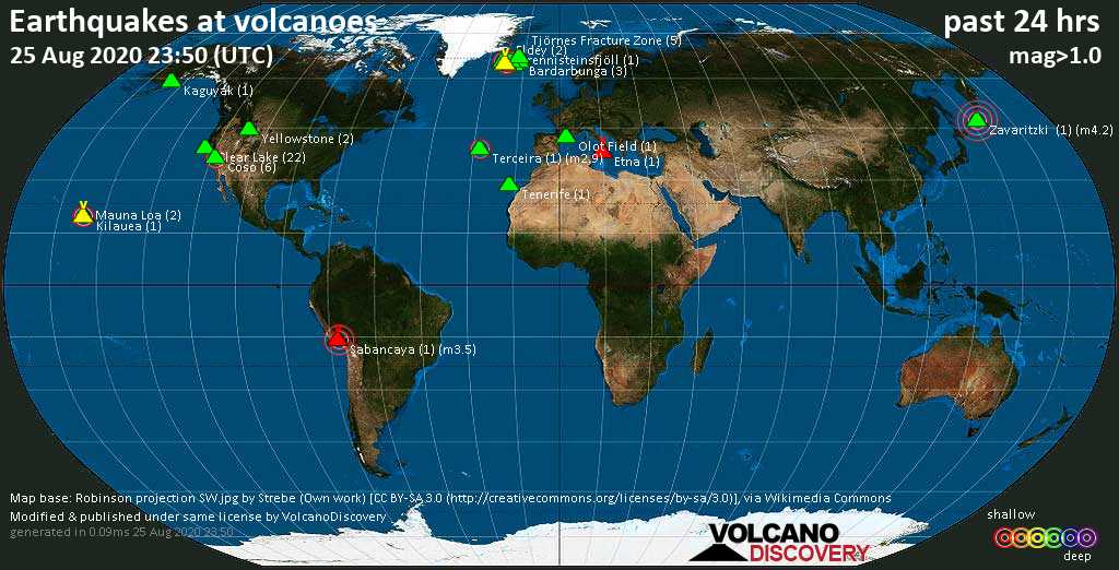
Wed, 2 Sep 2020, 23:50
Volcano earthquake report for Wednesday, 2 Sep 2020
Quakes detected near: Askja (6 quakes between mag 0.3-1.4), Bardarbunga (2 quakes between mag 0.5-1.3), Clear Lake (14 quakes between mag 0.2-1.9), Coso (16 quakes between mag 0.3-3.5), El Hierro (1 quake mag 1.9), Etna (1 quake mag 1.1) ... Read all
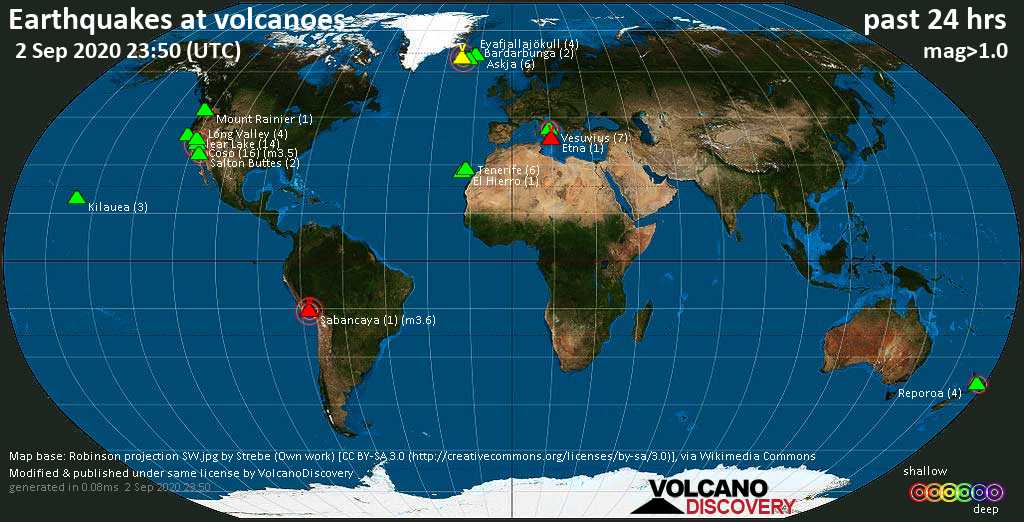
Tue, 1 Sep 2020, 23:50
Volcano earthquake report for Tuesday, 1 Sep 2020
Quakes detected near: Clear Lake (22 quakes between mag 0.3-2.1), Etna (3 quakes between mag 1.1-1.6), Hrómundartindur (2 quakes between mag 0.7-1.0), Kilauea (1 quake mag 2.0), Krísuvík (43 quakes between mag 0.1-1.7), Kverkfjöll (2 quakes between mag 0.7-1.0) ... Read all
Show more