Volcano earthquake report for Saturday, 20 Feb 2021
Sat, 20 Feb 2021, 23:50 | BY: EARTHQUAKEMONITOR
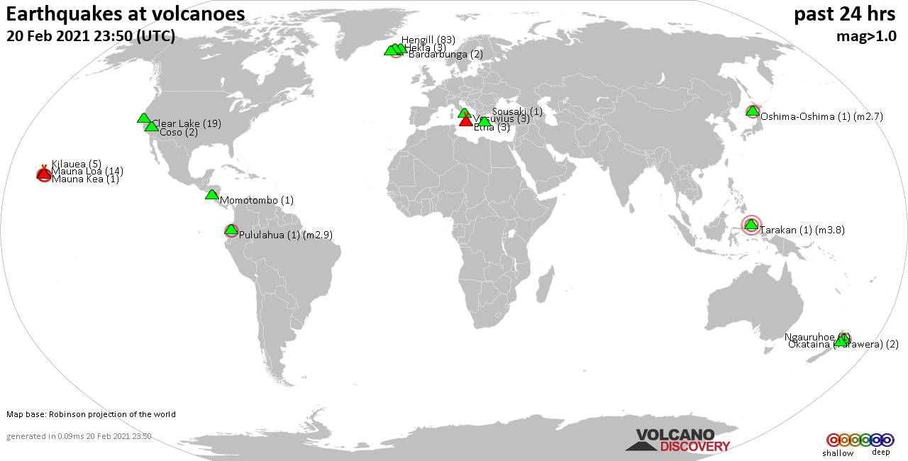
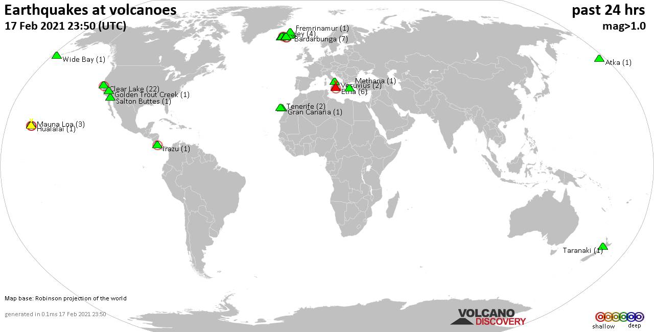
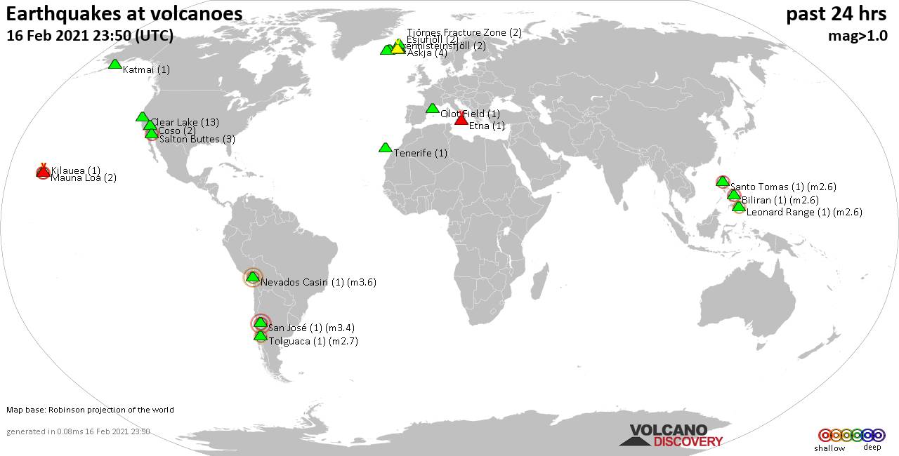
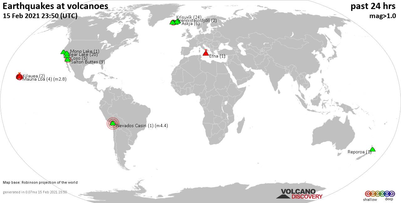
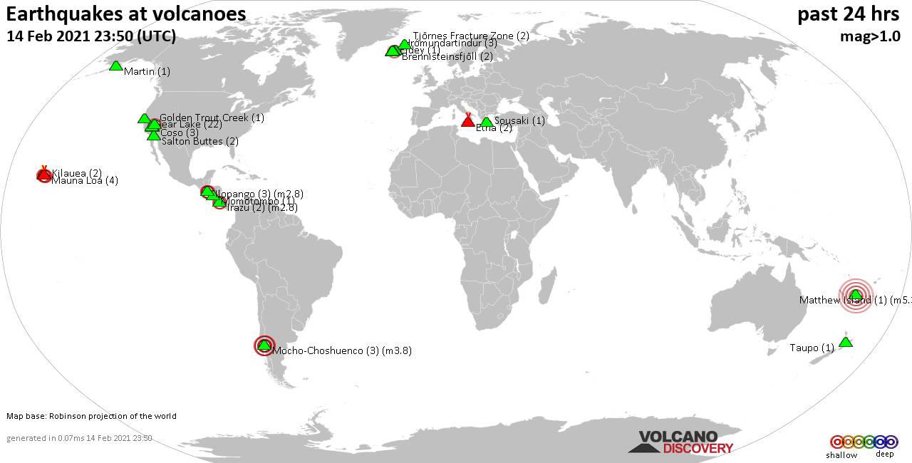
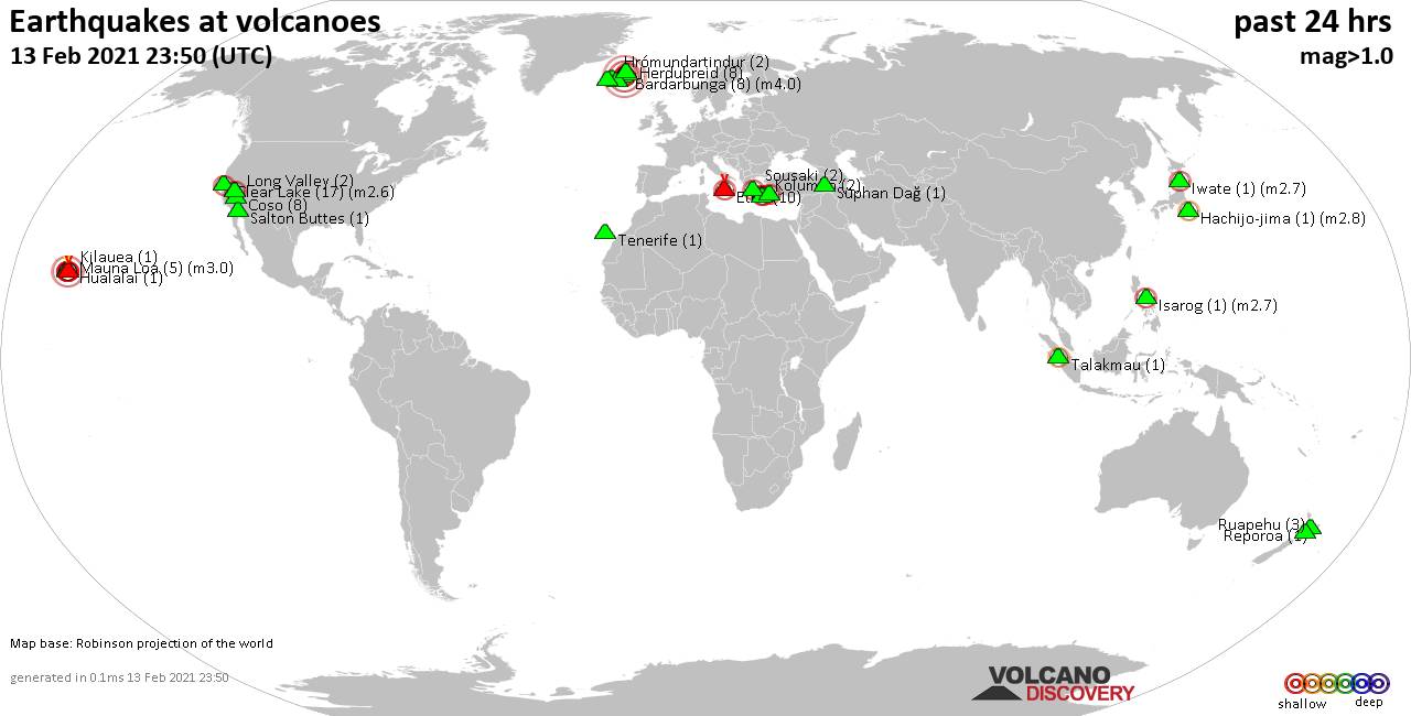
World map showing volcanoes with shallow (less than 20 km) earthquakes within 20 km radius during the past 24 hours on 20 Feb 2021 Number in brackets indicate nr of quakes.
Kilauea (5 quakes between mag 1.0-2.0), Krísuvík (7 quakes between mag 0.2-1.1), Mauna Kea (1 quake mag 1.5), Mauna Loa (14 quakes between mag 0.5-2.0), Momotombo (1 quake mag 1.9), Ngauruhoe (1 quake mag 1.2), Okataina (Tarawera) (2 quakes between mag 1.7-2.0), Oshima-Oshima (1 quake mag 2.7), Prestahnukur (1 quake mag 1.6), Pululahua (1 quake mag 2.9), Reykjanes (12 quakes between mag 0.2-1.5), Sousaki (1 quake mag 1.4), Tarakan (1 quake mag 3.8), Vesuvius (3 quakes between mag 0.1-1.1) (updated 23h50)
Note: Earthquakes within 20 km from and at depths less than 20 km under active volcanoes are reported. The list is not complete because many volcanoes are not monitored and/or seismic data in high resolution is not available publicly.
Volcanoes with recent earthquakes above magnitude 2 or more than 10 quakes are listed below:
Clear Lake volcano (California): 19 earthquakes up to magnitude 1.1
Possible earthquake swarm: 19 earthquakes occurred near (under) the volcano during 23 hours, the last being recorded quake 21 minutes ago. Hypocenter depths ranged between 3.0 and 0.1 km.Earthquake details: (only 5 largest)
1.1 quake 6km NW of The Geysers, CA, USA, 20 Feb 2021 3:29 pm (GMT -8) (18 km SSW)
1.0 quake 6km NW of The Geysers, CA, USA, 19 Feb 2021 6:55 pm (GMT -8) (17 km S)
1.0 quake 6km NW of The Geysers, CA, USA, 20 Feb 2021 12:49 pm (GMT -8) (17 km S)
1.0 quake 3km W of Cobb, CA, USA, 20 Feb 2021 10:35 am (GMT -8) (17 km S)
1.0 quake 6km NNW of The Geysers, CA, USA, 20 Feb 2021 8:04 am (GMT -8) (16 km S)
All earthquakes at Clear Lake
Hekla volcano (Iceland): 3 earthquakes up to magnitude 2.4
3 earthquakes occurred near (under) the volcano during 5 hours, the last being recorded quake 4 hours ago. Hypocenter depths ranged between 7.2 and 6.7 km.Earthquake details:
2.4 quake 14.6 Km SE of Árnes, Iceland, 20 Feb 2021 2:28 pm (GMT +0) (16 km W)
1.1 quake 14.1 Km ESE of Árnes, Iceland, 20 Feb 2021 5:58 pm (GMT +0) (16 km W)
0.8 quake 14.3 Km ESE of Árnes, Iceland, 20 Feb 2021 7:47 pm (GMT +0) (16 km W)
All earthquakes at Hekla
Hengill volcano (Iceland): 83 earthquakes up to magnitude 1.9
Possible earthquake swarm: 83 earthquakes occurred near (under) the volcano during 20 hours, the last being recorded quake 4 hours ago. Hypocenter depths ranged between 8.8 and 1.6 km.Earthquake details: (only 5 largest)
1.9 quake 2.3 Km ESE of Eiturhóll, Iceland, 19 Feb 2021 11:51 pm (GMT +0) (6 km SSW)
1.5 quake 0.7 Km ESE of Eiturhóll, Iceland, 20 Feb 2021 4:06 am (GMT +0) (7 km SSW)
1.4 quake 2.4 Km ESE of Eiturhóll, Iceland, 20 February 2021 01:54 GMT (7 km SSW)
1.3 quake 2.3 Km ESE of Eiturhóll, Iceland, 20 February 2021 04:53 GMT (6 km SSW)
1.3 quake 2.2 Km ESE of Eiturhóll, Iceland, 20 February 2021 03:00 GMT (7 km SSW)
All earthquakes at Hengill
Mauna Loa volcano (Hawai'i (Big Island)): 14 earthquakes up to magnitude 2.0
Possible earthquake swarm: 14 earthquakes occurred near (under) the volcano during 20 hours, the last being recorded quake 4 hours ago. Hypocenter depths ranged between 2.2 and 0.1 km.Earthquake details: (only 5 largest)
2.0 quake 27 Km E of Honaunau-Napoopoo, Hawaii, USA, 20 Feb 2021 1:10 am (GMT -10) (1 km ENE)
1.9 quake 27 Km E of Honaunau-Napoopoo, Hawaii, USA, 19 Feb 2021 8:16 pm (GMT -10) (2 km S)
1.8 quake 27 Km E of Honaunau-Napoopoo, Hawaii, USA, 19 Feb 2021 11:49 pm (GMT -10) (1 km E)
1.8 quake 28 Km E of Honaunau-Napoopoo, Hawaii, USA, 19 Feb 2021 9:06 pm (GMT -10) (4 km SSE)
1.7 quake 17 Km N of Pāhala, Hawaii, USA, 20 Feb 2021 4:44 am (GMT -10) (18 km SE)
All earthquakes at Mauna Loa
Oshima-Oshima volcano (Hokkaido): magnitude 2.7 earthquake
A magnitude 2.7 earthquake occurred at the volcano 18 hours ago. The quake, which might be volcanic in origin, was located at a depth of 4.2 km depth at 4 km distance SE from the volcano.Earthquake details:
2.7 quake Japan Sea, 76 km south of Okushiri Island, Hokkaido, Japan, 20 Feb 2021 2:31 pm (GMT +9) (4 km SE)
All earthquakes at Oshima-Oshima
Pululahua volcano (Ecuador): magnitude 2.9 earthquake
A magnitude 2.9 earthquake occurred at the volcano 22 hours ago. The quake, which might be volcanic in origin, was located at a depth of 6.0 km depth at 9 km distance SSE from the volcano.Earthquake details:
2.9 quake 23 km northeast of San Francisco de Quito, Ecuador, 19 Feb 2021 8:31 pm (GMT -5) (9 km SSE)
All earthquakes at Pululahua
Pululahua (also spelled as Pululgua) volcano is a low forested stratovolcano located immediately north of the equator, 15 km north of the capital Quito.
Reykjanes volcano (Iceland): 12 earthquakes up to magnitude 1.5
Possible earthquake swarm: 12 earthquakes occurred near (under) the volcano during 21 hours, the last being recorded quake 3 hours ago. Hypocenter depths ranged between 7.0 and 0.0 km.Earthquake details: (only 5 largest)
1.5 quake 2.6 Km WSW of Fagradalsfjall, Iceland, 20 Feb 2021 6:54 am (GMT +0) (10 km E)
1.4 quake 4.2 Km SSW of Fagradalsfjall, Iceland, 20 February 2021 02:37 GMT (11 km ESE)
0.9 quake 3.5 Km WSW of Fagradalsfjall, Iceland, 20 February 2021 00:34 GMT (9 km E)
0.8 quake 3.6 Km WSW of Fagradalsfjall, Iceland, 20 February 2021 08:51 GMT (9 km E)
0.8 quake 5.3 Km WSW of Fagradalsfjall, Iceland, 20 February 2021 06:11 GMT (7 km E)
All earthquakes at Reykjanes
Tarakan volcano (Halmahera): magnitude 3.8 earthquake
A magnitude 3.8 earthquake occurred at the volcano 15 hours ago. The quake, which might be volcanic in origin, was located at a depth of 10.0 km depth at 16 km distance NE from the volcano.Earthquake details:
3.8 quake Halmahera Sea, 24 km north of Tobelo, Indonesia, 20 Feb 2021 5:42 pm (GMT +9) (16 km NE)
All earthquakes at Tarakan
Previous news
Fri, 19 Feb 2021, 23:50
Volcano earthquake report for Friday, 19 Feb 2021
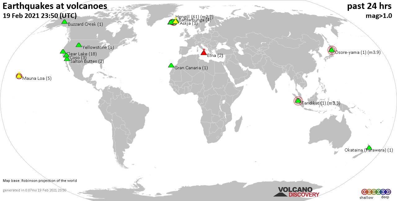
Quakes detected near: Askja (3 quakes between mag 0.6-1.0), Bardarbunga (4 quakes between mag 0.5-1.0), Buzzard Creek (1 quake mag 1.8), Clear Lake (18 quakes between mag 0.2-1.5), Coso (3 quakes between mag 0.6-1.0), Eldey (2 quakes between mag 0.8-1.3) ... Read all
Thu, 18 Feb 2021, 23:50
Volcano earthquake report for Thursday, 18 Feb 2021
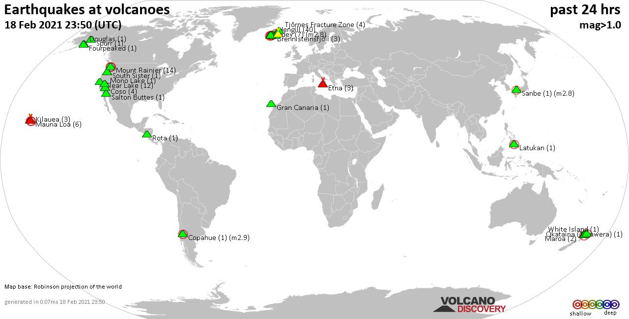
Quakes detected near: Brennisteinsfjöll (3 quakes between mag 0.8-1.0), Clear Lake (12 quakes between mag 0.1-1.6), Copahue (1 quake mag 2.9), Coso (4 quakes between mag 0.6-1.0), Douglas (1 quake mag 1.9), Eldey (7 quakes between mag 1.1-2.8) ... Read all
Show more