Volcano earthquake report for Saturday, 5 Jun 2021
Sat, 5 Jun 2021, 23:50 | BY: EARTHQUAKEMONITOR
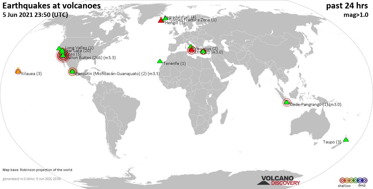
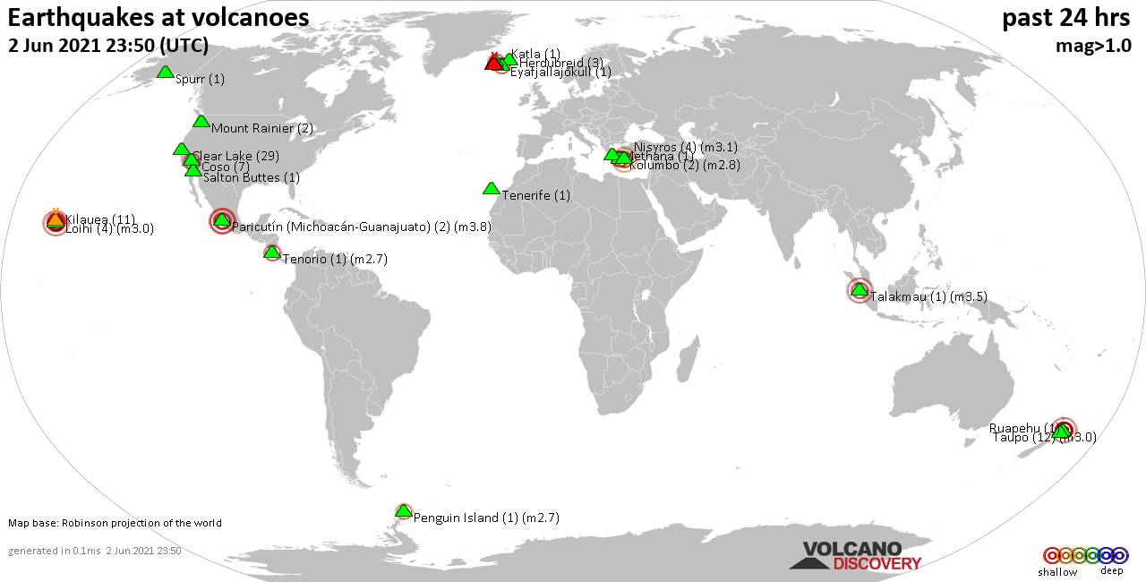
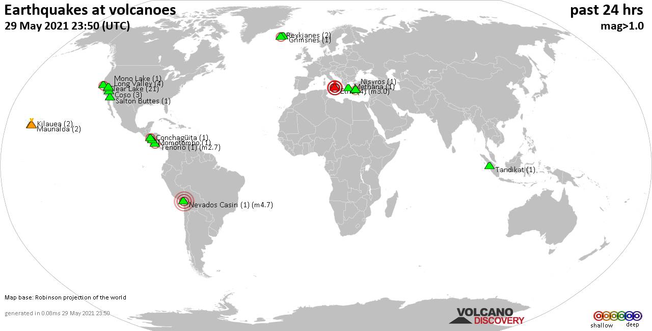
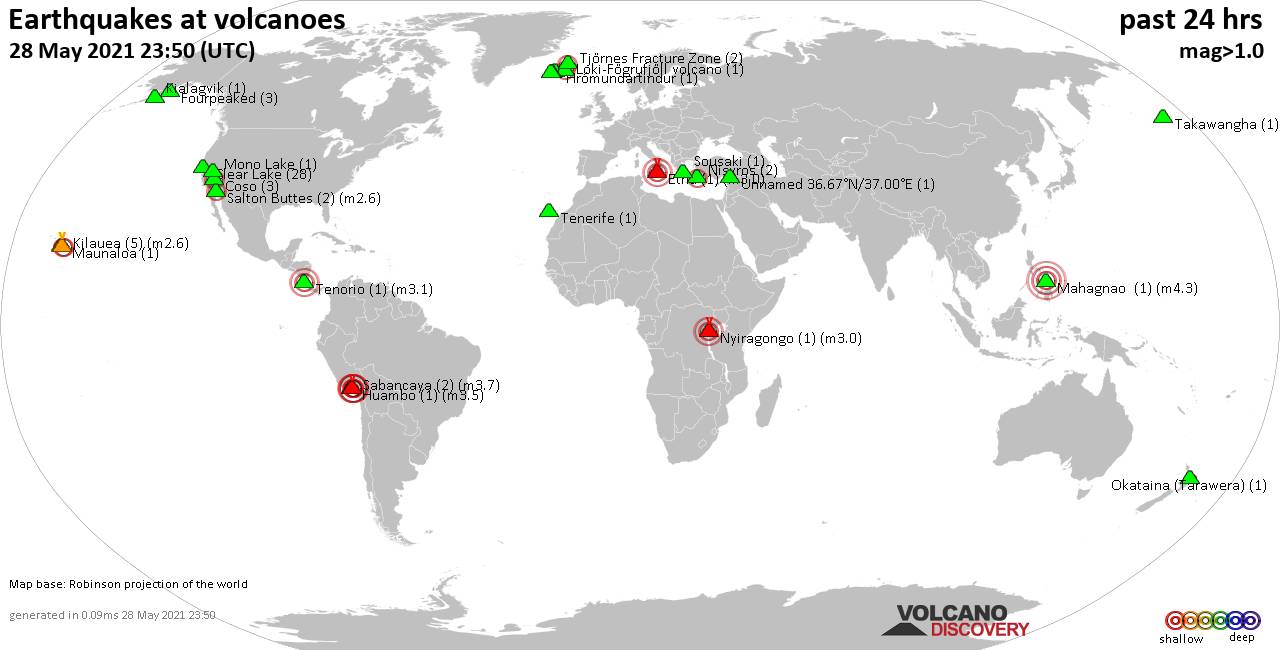
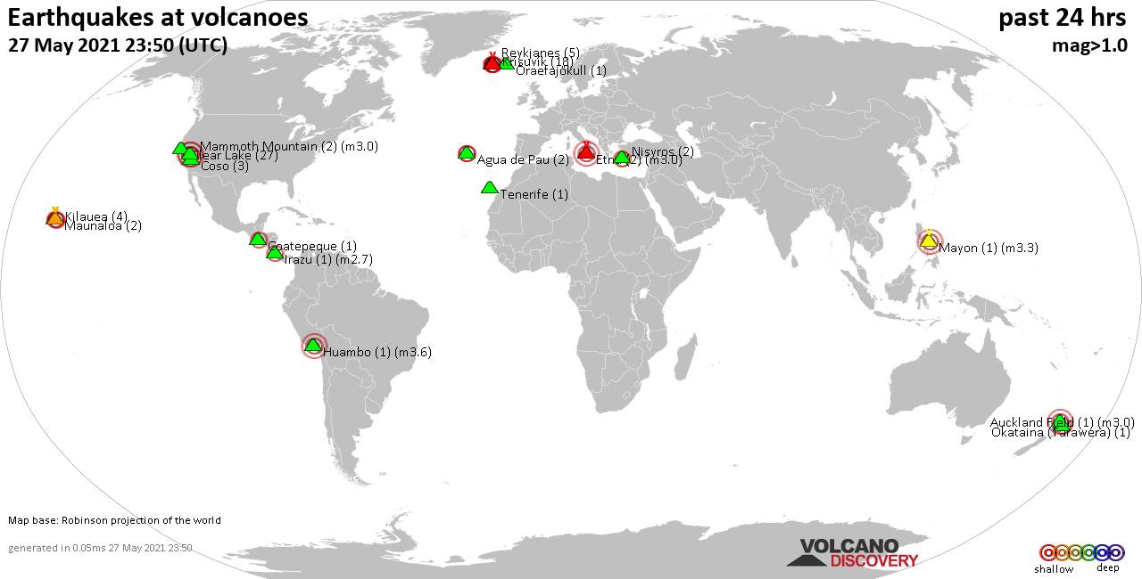
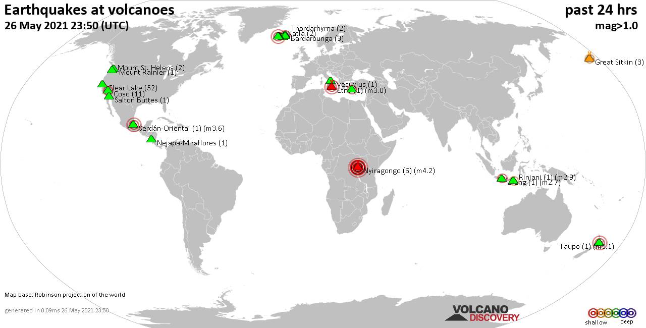
World map showing volcanoes with shallow (less than 20 km) earthquakes within 20 km radius during the past 24 hours on 5 Jun 2021 Number in brackets indicate nr of quakes.
Kilauea (3 quakes between mag 1.7-2.3), Long Valley (1 quake mag 2.5), Nisyros (4 quakes between mag 2.0-2.5), Paricutín (Michoacán-Guanajuato) (2 quakes between mag 3.4-3.5), Salton Buttes (266 quakes between mag 1.0-5.3), Taupo (3 quakes between mag 1.3-1.9), Tenerife (1 quake mag 1.1), Tjörnes Fracture Zone (1 quake mag 1.0), Vesuvius (2 quakes between mag 0.8-1.0) (updated 23h50)
Note: Earthquakes within 20 km from and at depths less than 20 km under active volcanoes are reported. The list is not complete because many volcanoes are not monitored and/or seismic data in high resolution is not available publicly.
Volcanoes with recent earthquakes above magnitude 2 or more than 10 quakes are listed below:
Clear Lake volcano (California): 20 earthquakes up to magnitude 1.9
Possible earthquake swarm: 20 earthquakes occurred near (under) the volcano during 17 hours, the last being recorded quake 5 hours ago. Hypocenter depths ranged between 3.2 and 1.6 km.Earthquake details: (only 5 largest)
1.9 quake 7km NW of The Geysers, CA, 5 June 2021 03:30 GMT (17 km S)
1.0 quake 8km NW of The Geysers, CA, 5 June 2021 16:29 GMT (16 km SSW)
1.0 quake 4km W of Cobb, CA, 5 June 2021 15:13 GMT (16 km S)
1.0 quake 7km WNW of The Geysers, CA, 5 June 2021 17:27 GMT (19 km SSW)
0.9 quake 2km N of The Geysers, CA, 5 June 2021 05:37 GMT (19 km S)
All earthquakes at Clear Lake
Etna volcano (Italy): 2 earthquakes up to magnitude 3.0
2 earthquakes occurred near (under) the volcano during 11 hours, the last being recorded quake 9 hours ago. Hypocenter depths ranged between 10.0 and 10.0 km.Earthquake details:
Unconfirmed quake reported: 30 km north of Catina, Catania, Sicily, Italy, 5 June 2021 14:26 GMT (0 km SW)
Unconfirmed quake reported: 30 km north of Catina, Catania, Sicily, Italy, 5 June 2021 03:14 GMT (0 km SW)
All earthquakes at Etna
Gede-Pangrango volcano (West Java): magnitude 3.0 earthquake
A magnitude 3.0 earthquake occurred at the volcano 18 hours ago. The quake, which might be volcanic in origin, was located at a depth of 10.0 km depth at 19 km distance S from the volcano.Earthquake details:
3.0 quake 5.1 km southeast of Sukabumi, West Java, Indonesia, 5 June 2021 05:47 GMT (19 km S)
All earthquakes at Gede-Pangrango
Kilauea volcano (Hawai'i (Big Island)): 3 earthquakes up to magnitude 2.3
3 earthquakes occurred near (under) the volcano during 9 hours, the last being recorded quake 4 hours ago. Hypocenter depths ranged between 7.3 and 1.5 km.Earthquake details:
2.3 quake Island of Hawaii, Hawaii, 5 June 2021 15:04 GMT (3 km SSE)
1.9 quake 10 Km SW of Volcano, Hawaii, 5 June 2021 10:09 GMT (4 km SW)
1.7 quake 11 Km SSE of Volcano, Hawaii, 5 June 2021 19:27 GMT (12 km SE)
All earthquakes at Kilauea
Long Valley volcano (California): magnitude 2.5 earthquake
A magnitude 2.5 earthquake occurred at the volcano 6 hours ago. The quake, which might be volcanic in origin, was located at a depth of 4.2 km depth at 18 km distance SSE from the volcano.Earthquake details:
2.5 quake 13km WSW of Toms Place, CA, 5 June 2021 17:52 GMT (18 km SSE)
All earthquakes at Long Valley
Nisyros volcano (Greece): 4 earthquakes up to magnitude 2.5
4 earthquakes occurred near (under) the volcano during 12 hours, the last being recorded quake 6 hours ago. Hypocenter depths ranged between 14.3 and 10.1 km.Earthquake details:
2.5 quake Aegean Sea, 48 km south of Kos Town, Dodecanese, South Aegean, Greece, 5 June 2021 05:58 GMT (11 km SSW)
2.4 quake Aegean Sea, 50 km south of Kos Town, Dodecanese, South Aegean, Greece, 5 June 2021 17:29 GMT (15 km S)
2.3 quake Aegean Sea, 61 km southwest of Kos Town, Dodecanese, South Aegean, Greece, 5 June 2021 16:46 GMT (15 km SW)
2.0 quake Aegean Sea, 41 km south of Kos Town, Dodecanese, South Aegean, Greece, 5 June 2021 06:31 GMT (18 km ESE)
All earthquakes at Nisyros
Paricutín (Michoacán-Guanajuato) volcano (Western & Central Mexico): 2 earthquakes up to magnitude 3.5
2 earthquakes occurred near (under) the volcano during 2 hours, the last being recorded quake 14 hours ago. Hypocenter depths ranged between 15.0 and 8.0 km.Earthquake details:
3.5 quake Nuevo Parangaricutiro, 18 km west of Uruapan, Michoacan, Mexico, 2021-06-05 04:49:53 (Hora de México) (10 km SSE)
3.4 quake 22 km northwest of Uruapan, Michoacan, Mexico, 2021-06-05 02:28:16 (Hora de México) (14 km NE)
All earthquakes at Paricutín (Michoacán-Guanajuato)
Salton Buttes volcano (California): 266 earthquakes up to magnitude 5.3
Possible earthquake swarm: 266 earthquakes occurred near (under) the volcano during 16 hours, the last being recorded quake 11 minutes ago. Hypocenter depths ranged between 18.6 and 0.3 km.Earthquake details: (only 5 largest)
5.3 quake 13 mi northwest of Brawley, Imperial County, California, USA, 5 Jun 10:55 am (GMT -7) (6 km S)
4.3 quake 13 mi northwest of Brawley, Imperial County, California, USA, 5 Jun 2021 10:45 am (GMT -7) (7 km SSW)
4.3 quake 13 mi northwest of Brawley, Imperial County, California, USA, 5 Jun 10:57 am (GMT -7) (5 km S)
4.2 quake 13 mi northwest of Brawley, Imperial County, California, USA, 5 Jun 11:21 am (GMT -7) (5 km S)
4.0 quake 13 mi northwest of Brawley, Imperial County, California, USA, 5 Jun 2021 10:50 am (GMT -7) (6 km SSW)
All earthquakes at Salton Buttes
Previous news
Fri, 4 Jun 2021, 23:50
Volcano earthquake report for Friday, 4 Jun 2021
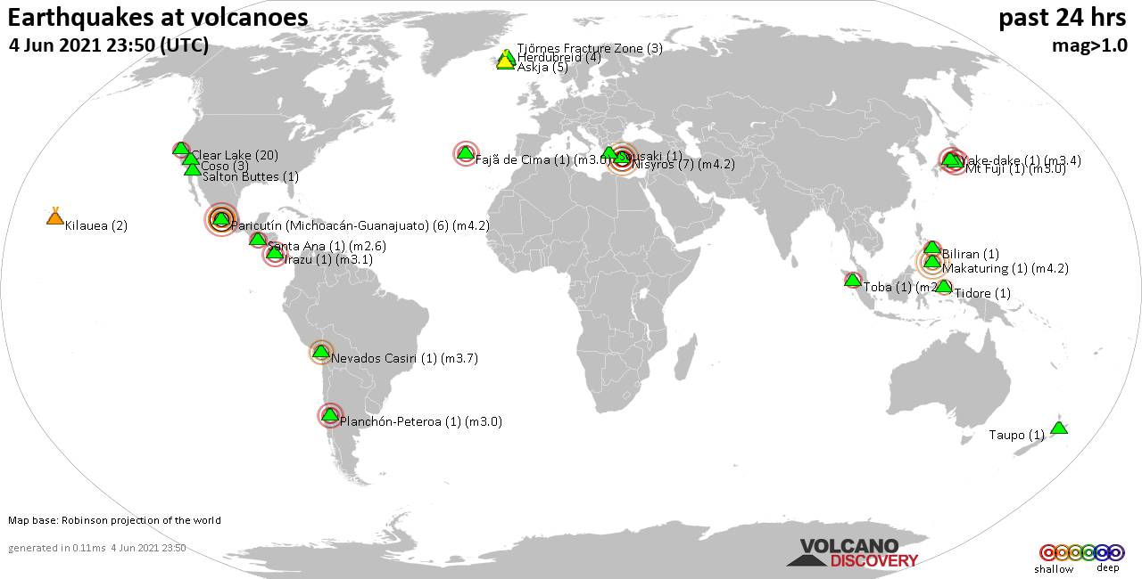
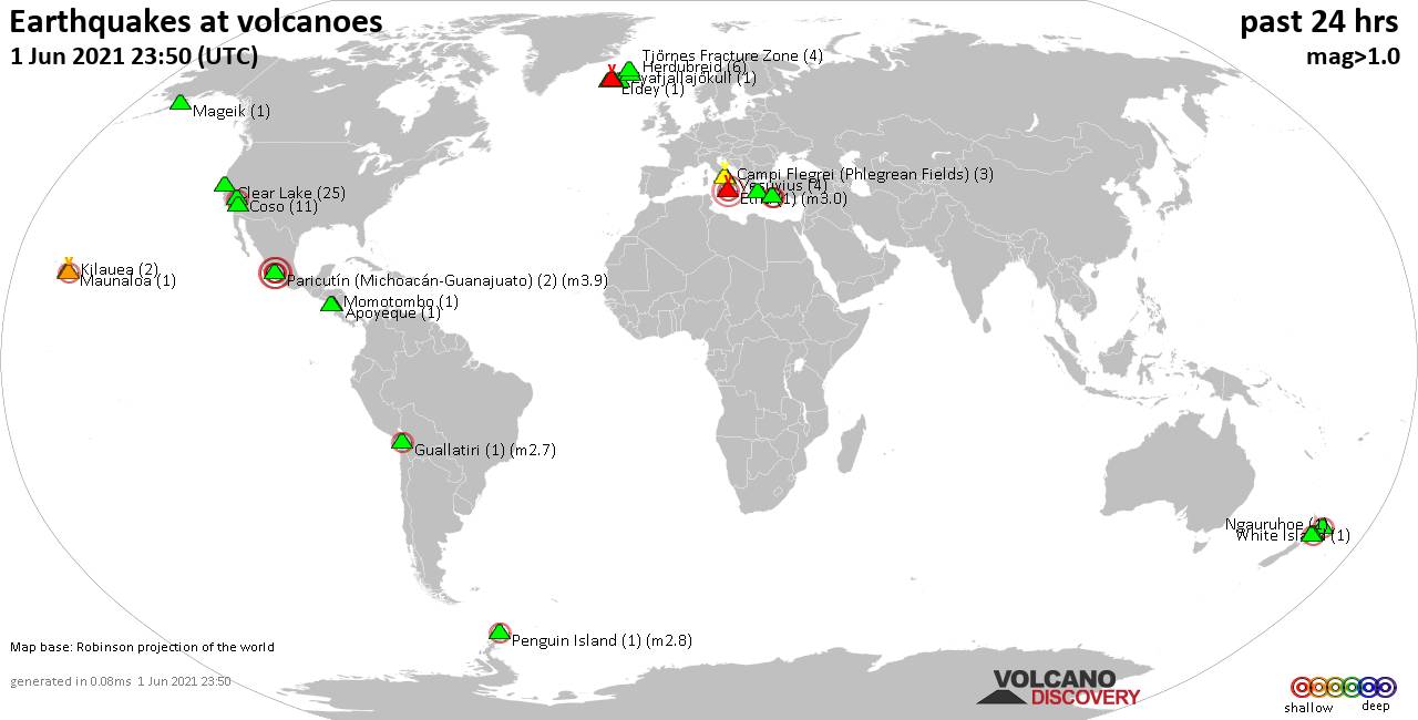
Quakes detected near: Askja (5 quakes between mag 0.2-1.0), Biliran (1 quake mag 2.2), Clear Lake (20 quakes between mag 0.4-2.0), Coso (3 quakes between mag 0.6-1.0), Fajã de Cima (1 quake mag 3.0), Grímsvötn (2 quakes between mag 0.8-1.1) ... Read all
Thu, 3 Jun 2021, 23:50
Volcano earthquake report for Thursday, 3 Jun 2021
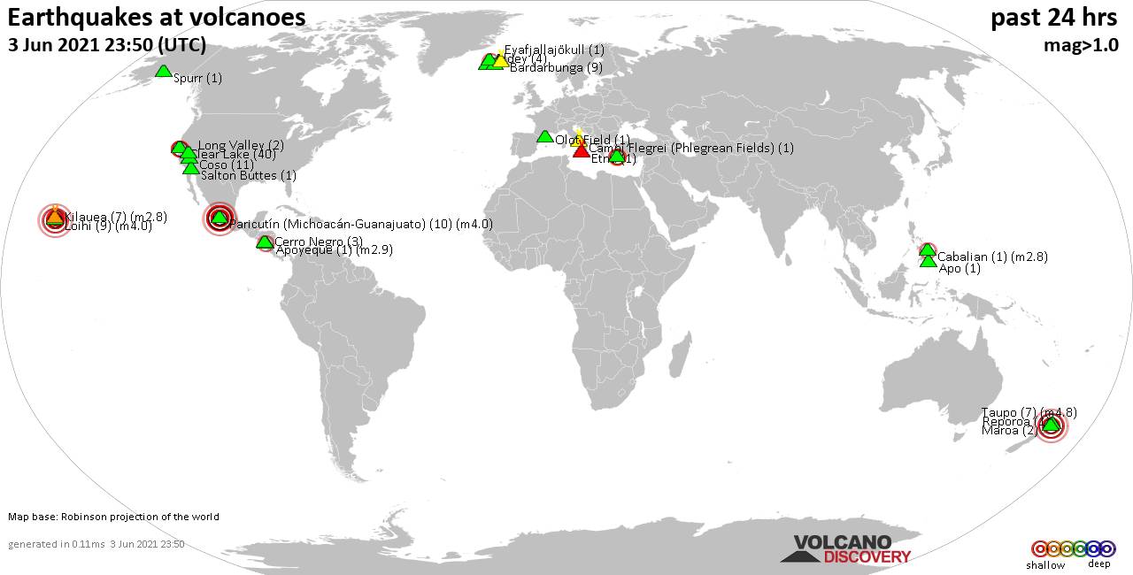
Quakes detected near: Apo (1 quake mag 1.7), Apoyeque (1 quake mag 2.9), Bardarbunga (9 quakes between mag 0.1-1.4), Cabalian (1 quake mag 2.8), Campi Flegrei (Phlegrean Fields) (1 quake mag 1.0), Cerro Negro (3 quakes between mag 0.8-1.6) ... Read all
Show more