Volcano earthquake report for Saturday, 2 Oct 2021
Sat, 2 Oct 2021, 23:50 | BY: EARTHQUAKEMONITOR
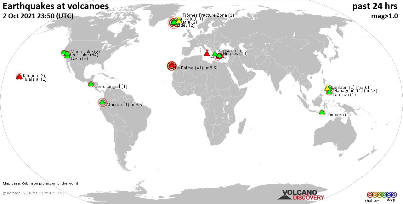
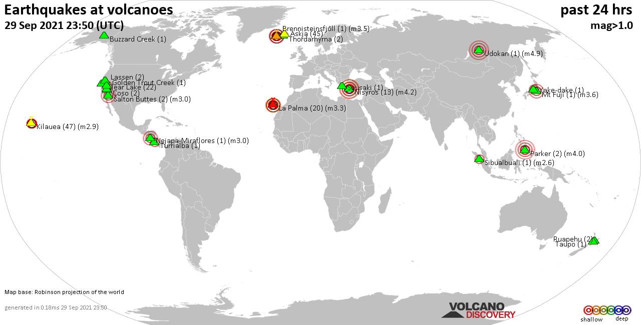
World map showing volcanoes with shallow (less than 20 km) earthquakes within 20 km radius during the past 24 hours on 2 Oct 2021 Number in brackets indicate nr of quakes.
Eldey (2 quakes between mag 1.3-1.7), Etna (1 quake mag 1.9), Hualalai (1 quake mag 2.2), Katla (2 quakes between mag 1.0-1.0), Kilauea (2 quakes between mag 1.7-1.9), Krísuvík (169 quakes between mag 0.1-4.2), La Palma (41 quakes between mag 2.1-3.6), Latukan (1 quake mag 2.5), Ljósufjöll (1 quake mag 2.3), Mahagnao (1 quake mag 2.7), Mono Lake (2 quakes between mag 1.9-2.0), Nisyros (13 quakes between mag 1.5-2.2), Sousaki (1 quake mag 2.1), Tambora (1 quake mag 2.3), Tjörnes Fracture Zone (1 quake mag 1.1) (updated 23h50)
Note: Earthquakes within 20 km from and at depths less than 20 km under active volcanoes are reported. The list is not complete because many volcanoes are not monitored and/or seismic data in high resolution is not available publicly.
Volcanoes with recent earthquakes above magnitude 2 or more than 10 quakes are listed below:
Atacazo volcano (Ecuador): magnitude 3.6 earthquake
A magnitude 3.6 earthquake occurred at the volcano 20 hours ago. The quake, which might be volcanic in origin, was located at a depth of 6.0 km depth at 13 km distance SW from the volcano.Earthquake details:
3.6 quake Canton Mejia, 32 km southwest of San Francisco de Quito, Ecuador, Oct 1, 2021 10:36 pm (GMT -5) (13 km SW)
All earthquakes at Atacazo
Canlaon volcano (Central Philippines): magnitude 2.6 earthquake
A magnitude 2.6 earthquake occurred at the volcano 4 hours ago. The quake, which might be volcanic in origin, was located at a depth of 9.0 km depth at 14 km distance SSE from the volcano.Earthquake details:
2.6 quake Province of Negros Oriental, Central Visayas, 19 km northeast of Tinongan, Philippines, Oct 3, 2021 4:09 am (GMT +8) (14 km SSE)
All earthquakes at Canlaon
Clear Lake volcano (California): 34 earthquakes up to magnitude 2.1
Possible earthquake swarm: 34 earthquakes occurred near (under) the volcano during 22 hours, the last being recorded quake 1 hour 42 minutes ago. Hypocenter depths ranged between 2.8 and 0.3 km.Earthquake details: (only 5 largest)
2.1 quake 10km NW of The Geysers, CA, Oct 2, 2021 4:37 am (GMT -7) (16 km SSW)
1.8 quake 4km W of Cobb, CA, Oct 2, 2021 7:09 am (GMT -7) (16 km S)
1.7 quake 2km N of The Geysers, CA, Oct 1, 2021 8:07 pm (GMT -7) (19 km S)
1.7 quake 6km WNW of The Geysers, CA, Oct 2, 2021 5:55 am (GMT -7) (19 km S)
1.4 quake 10km NW of The Geysers, CA, Oct 2, 2021 4:42 am (GMT -7) (16 km SSW)
All earthquakes at Clear Lake
Hualalai volcano (Hawai'i (Big Island)): magnitude 2.2 earthquake
A magnitude 2.2 earthquake occurred at the volcano 18 hours ago. The quake, which might be volcanic in origin, was located at a depth of 1.0 km depth at 14 km distance WSW from the volcano.Earthquake details:
2.2 quake 9.2 mi west of Holualoa, Hawaii County, USA, Oct 1, 2021 8:09 pm (GMT -10) (14 km WSW)
All earthquakes at Hualalai
Krísuvík volcano (Reykjanes Peninsula, Iceland): 169 earthquakes up to magnitude 4.2
Possible earthquake swarm: 169 earthquakes occurred near (under) the volcano during 24 hours, the last being recorded quake 12 minutes ago. Hypocenter depths ranged between 9.7 and 0.1 km.Earthquake details: (only 5 largest)
4.2 quake Iceland: 0.8 Km SW of Keilir Oct 2, 2021 3:32 pm (GMT +0) (4 km W)
3.1 quake Iceland: 1.2 Km SSW of Keilir Oct 2, 2021 8:26 pm (GMT +0) (4 km W)
3.0 quake Iceland: 1.2 Km SW of Keilir Oct 2, 2021 5:01 am (GMT +0) (4 km W)
3.0 quake Iceland: 0.9 Km W of Keilir Oct 2, 2021 3:42 am (GMT +0) (5 km W)
2.6 quake Iceland: 0.5 Km SSW of Keilir Oct 2, 2021 1:30 am (GMT +0) (4 km W)
All earthquakes at Krísuvík
La Palma volcano (Canary Islands): 41 earthquakes up to magnitude 3.6
Possible earthquake swarm: 41 earthquakes occurred near (under) the volcano during 20 hours, the last being recorded quake 3 hours ago. Hypocenter depths ranged between 18.0 and 1.0 km.Earthquake details: (only 5 largest)
3.6 quake La Palma Island, 13 km southeast of Los Llanos de Aridane, Spain, Oct 2, 2021 1:12 pm (GMT +1) (2 km S)
3.5 quake La Palma Island, 13 km southeast of Los Llanos de Aridane, Spain, Oct 2, 2021 10:33 am (GMT +1) (4 km S)
3.4 quake 14 km southeast of Los Llanos de Aridane, Tenerife, Canary Islands, Spain, Oct 2, 2021 10:35 am (GMT +1) (1 km SSE)
3.2 quake La Palma Island, 14 km southeast of Los Llanos de Aridane, Spain, Oct 2, 2021 7:12 pm (GMT +1) (2 km S)
3.1 quake 14 km southeast of Los Llanos de Aridane, Tenerife, Canary Islands, Spain, Oct 2, 2021 9:36 pm (GMT +1) (4 km SSW)
All earthquakes at La Palma
Latukan volcano (Mindanao): magnitude 2.5 earthquake
A magnitude 2.5 earthquake occurred at the volcano 11 hours ago. The quake, which might be volcanic in origin, was located at a depth of 2.0 km depth at 6 km distance NW from the volcano.Earthquake details:
2.5 quake 38 km southeast of Marawi City, Philippines, Oct 2, 2021 8:30 pm (GMT +8) (6 km NW)
All earthquakes at Latukan
Ljósufjöll volcano (Iceland): magnitude 2.3 earthquake
A magnitude 2.3 earthquake occurred at the volcano 8 hours ago. The quake, which might be volcanic in origin, was located at a depth of 14.1 km depth at 15 km distance NNW from the volcano.Earthquake details:
2.3 quake Iceland: 20.2 Km ESE of Stykkishólmur Oct 2, 2021 3:35 pm (GMT +0) (15 km NNW)
All earthquakes at Ljósufjöll
Mahagnao volcano (Central Philippines): magnitude 2.7 earthquake
A magnitude 2.7 earthquake occurred at the volcano 24 hours ago. The quake, which might be volcanic in origin, was located at a depth of 9.0 km depth at 19 km distance SE from the volcano.Earthquake details:
2.7 quake 3.4 km west of Abuyog, Leyte, Eastern Visayas, Philippines, Oct 2, 2021 7:57 am (GMT +8) (19 km SE)
All earthquakes at Mahagnao
Nisyros volcano (Greece): 13 earthquakes up to magnitude 2.2
Possible earthquake swarm: 13 earthquakes occurred near (under) the volcano during 22 hours, the last being recorded quake 1 hour 13 minutes ago. Hypocenter depths ranged between 16.9 and 4.4 km.Earthquake details: (only 5 largest)
2.2 quake Aegean Sea, 49 km south of Kos, Dodecanese, South Aegean, Greece, Oct 2, 2021 3:59 am (GMT +3) (14 km SSE)
2.2 quake Aegean Sea, 48 km south of Kos, Dodecanese, South Aegean, Greece, Oct 2, 2021 9:11 am (GMT +3) (12 km S)
2.0 quake Aegean Sea, 48 km south of Kos, Dodecanese, South Aegean, Greece, Oct 3, 2021 1:37 am (GMT +3) (14 km SSE)
2.0 quake Aegean Sea, 50 km south of Kos, Dodecanese, South Aegean, Greece, Oct 2, 2021 8:56 am (GMT +3) (13 km SSW)
2.0 quake Aegean Sea, 49 km south of Kos, Dodecanese, South Aegean, Greece, Oct 2, 2021 4:33 am (GMT +3) (14 km S)
All earthquakes at Nisyros
Sousaki volcano (Greece): magnitude 2.1 earthquake
A magnitude 2.1 earthquake occurred at the volcano 15 hours ago. The quake, which might be volcanic in origin, was located at a depth of 10.7 km depth at 13 km distance SSE from the volcano.Earthquake details:
2.1 quake 24 km south of Heraklion, Crete, Greece, Oct 2, 2021 11:52 am (GMT +3) (13 km SSE)
All earthquakes at Sousaki
Tambora volcano (Sumbawa): magnitude 2.3 earthquake
A magnitude 2.3 earthquake occurred at the volcano 20 hours ago. The quake, which might be volcanic in origin, was located at a depth of 17.0 km depth at 11 km distance ENE from the volcano.Earthquake details:
2.3 quake 53 km northwest of Dompu, West Nusa Tenggara, Indonesia, Oct 2, 2021 11:58 am (GMT +8) (11 km ENE)
All earthquakes at Tambora
Previous news
Fri, 1 Oct 2021, 23:50
Volcano earthquake report for Friday, 1 Oct 2021
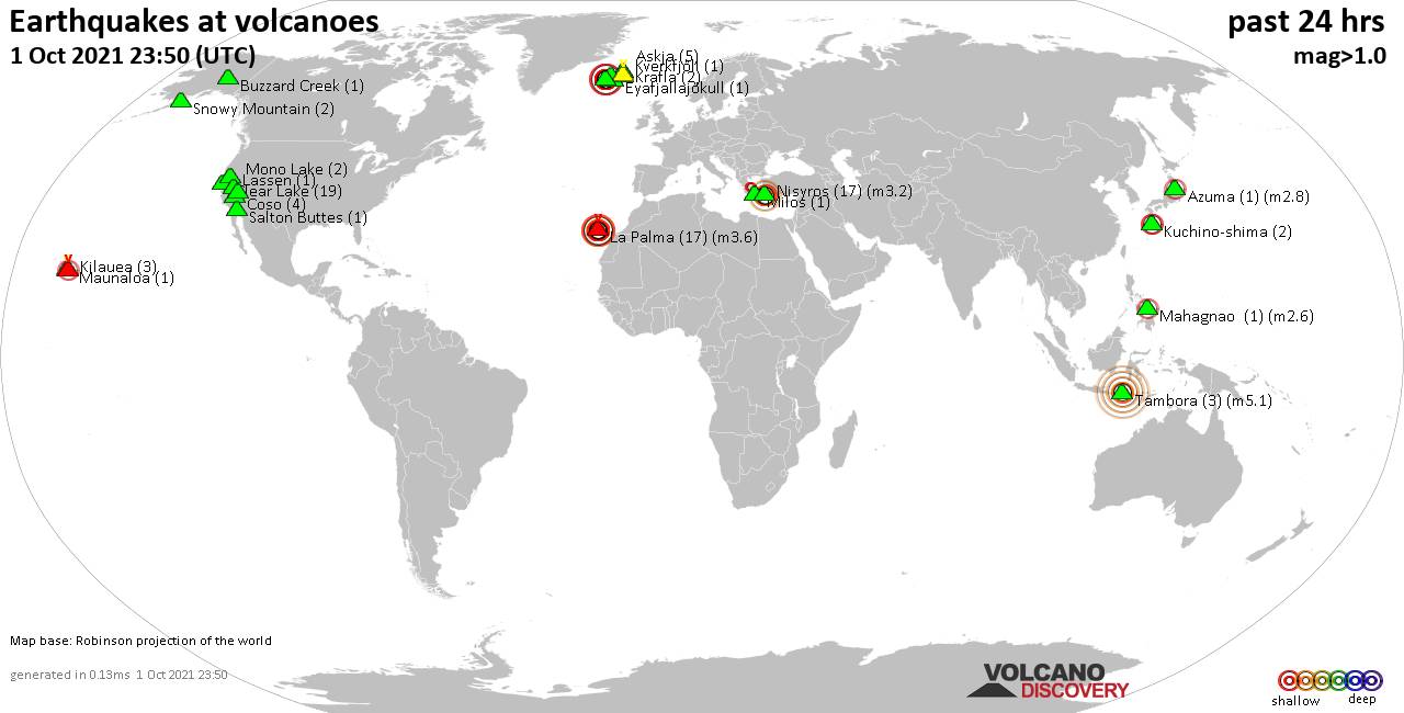
Quakes detected near: Askja (5 quakes between mag 0.5-1.1), Azuma (1 quake mag 2.8), Buzzard Creek (1 quake mag 1.7), Clear Lake (19 quakes between mag 0.4-1.5), Coso (4 quakes between mag 0.7-1.6), Eyafjallajökull (1 quake mag 1.6) ... Read all
Thu, 30 Sep 2021, 23:50
Volcano earthquake report for Thursday, 30 Sep 2021
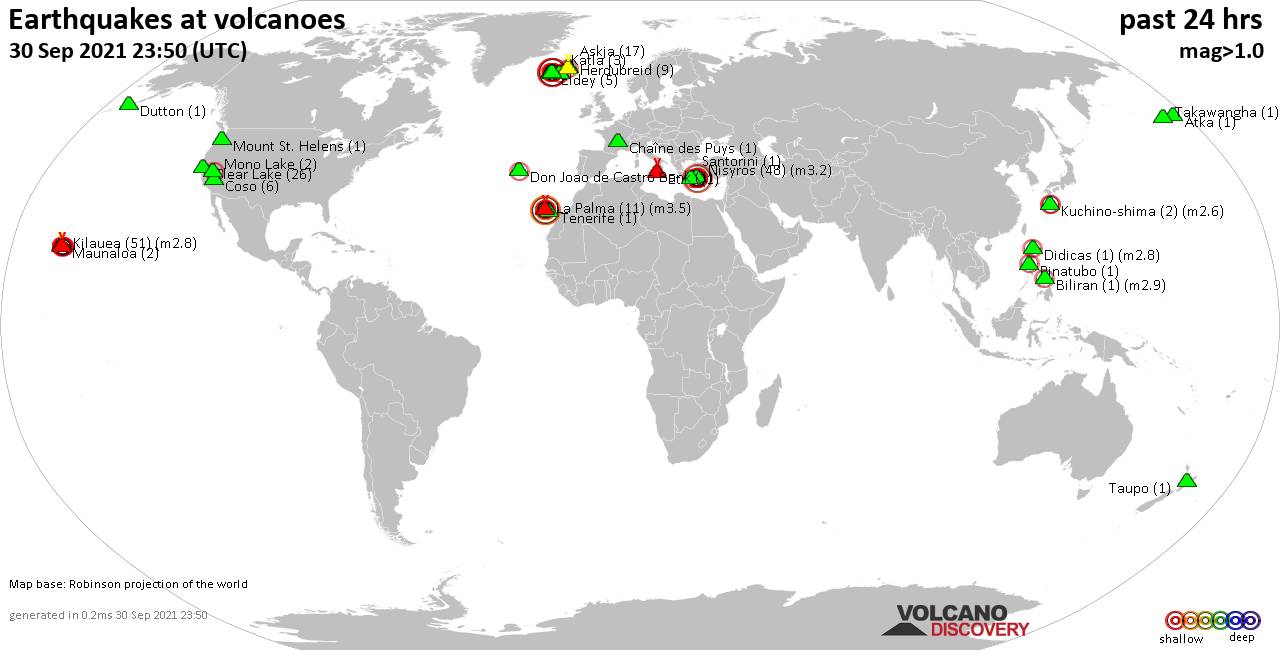
Quakes detected near: Askja (17 quakes between mag 0.1-2.0), Atka (1 quake mag 1.0), Biliran (1 quake mag 2.9), Chaîne des Puys (1 quake mag 1.1), Clear Lake (26 quakes between mag 0.4-1.2), Coso (6 quakes between mag 0.4-1.1) ... Read all
Show more