Volcano earthquake report for Friday, 5 Mar 2021
Fri, 5 Mar 2021, 23:50 | BY: EARTHQUAKEMONITOR

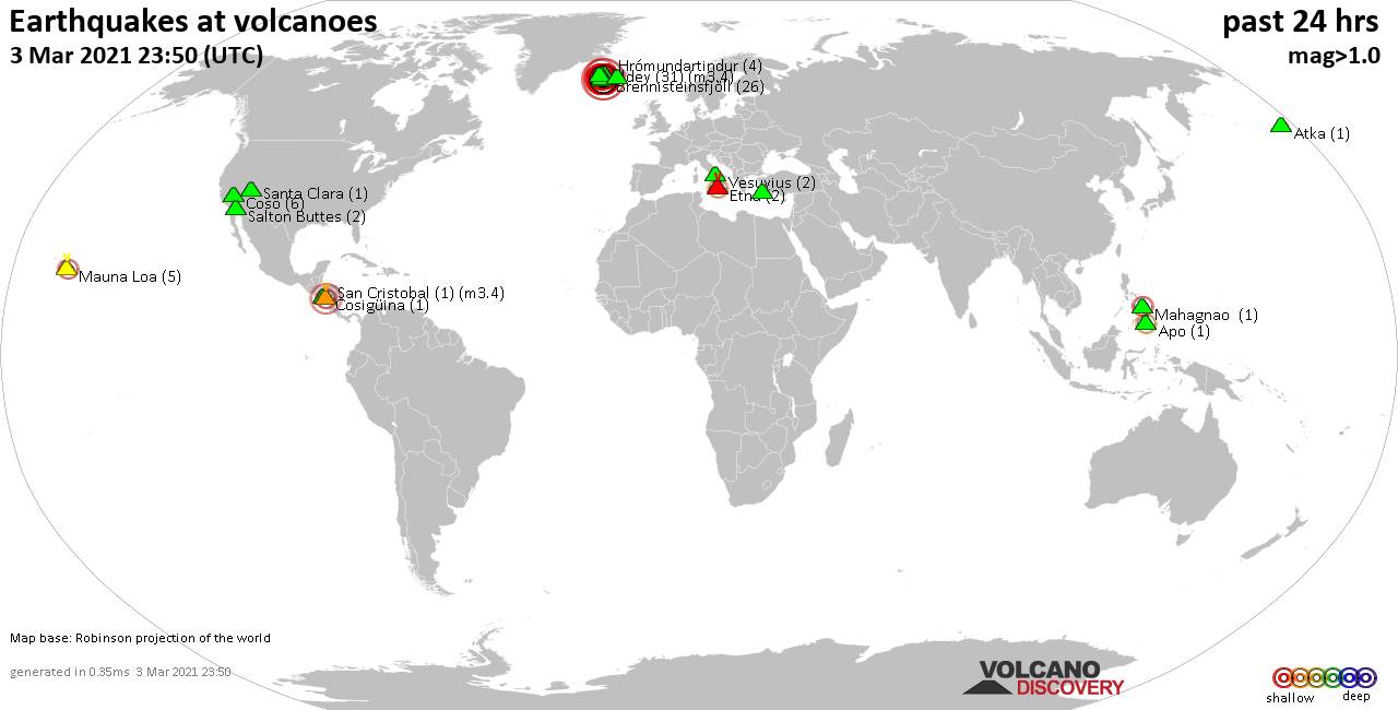
World map showing volcanoes with shallow (less than 20 km) earthquakes within 20 km radius during the past 24 hours on 5 Mar 2021 Number in brackets indicate nr of quakes.
Eldey (11 quakes between mag 0.2-2.3), Etna (1 quake mag 1.0), Eyafjallajökull (1 quake mag 2.7), Herdubreid (3 quakes between mag 0.2-1.5), Hrómundartindur (2 quakes between mag 0.6-1.7), Katla (2 quakes between mag 1.8-3.1), Kilauea (1 quake mag 2.2), Krísuvík (1137 quakes between mag 0.1-4.1), Long Valley (3 quakes between mag 0.4-1.0), Lysuhóll (2 quakes between mag 2.3-3.0), Mahagnao (1 quake mag 3.0), Matutum (1 quake mag 3.2), Mauna Loa (2 quakes between mag 0.7-2.0), Methana (1 quake mag 2.1), Reporoa (1 quake mag 1.7), Reykjanes (441 quakes between mag 0.1-3.0), Salton Buttes (3 quakes between mag 0.8-1.6), Snaefellsjökull (1 quake mag 1.9), Sousaki (1 quake mag 2.2) (updated 23h50)
Note: Earthquakes within 20 km from and at depths less than 20 km under active volcanoes are reported. The list is not complete because many volcanoes are not monitored and/or seismic data in high resolution is not available publicly.
Volcanoes with recent earthquakes above magnitude 2 or more than 10 quakes are listed below:
Atacazo volcano (Ecuador): magnitude 2.3 earthquake
A magnitude 2.3 earthquake occurred at the volcano 20 hours ago. The quake, which might be volcanic in origin, was located at a depth of 4.0 km depth at 16 km distance ENE from the volcano.Earthquake details:
2.3 quake 7.7 km southeast of San Francisco de Quito, Ecuador, 4 Mar 2021 10:36 pm (GMT -5) (16 km ENE)
All earthquakes at Atacazo
Buzzard Creek volcano (Eastern Alaska): 2 earthquakes up to magnitude 2.8
2 earthquakes occurred near (under) the volcano during 20 hours, the last being recorded quake 2 hours ago. Hypocenter depths ranged between 6.4 and 0.0 km.Earthquake details:
2.8 quake Denali County, 62 mi southwest of Fairbanks, Alaska, USA, 5 Mar 2021 12:45 pm (GMT -9) (8 km SW)
2.0 quake 24 Km E of Ferry, Alaska, USA, 4 Mar 2021 4:48 pm (GMT -9) (8 km WSW)
All earthquakes at Buzzard Creek
Clear Lake volcano (California): 21 earthquakes up to magnitude 1.8
Possible earthquake swarm: 21 earthquakes occurred near (under) the volcano during 20 hours, the last being recorded quake 3 hours ago. Hypocenter depths ranged between 4.4 and 1.3 km.Earthquake details: (only 5 largest)
1.8 quake 7km E of Clearlake Oaks, CA, USA, 5 Mar 2021 12:19 pm (GMT -8) (16 km ENE)
1.7 quake 5km NW of The Geysers, CA, USA, 5 Mar 2021 5:40 am (GMT -8) (18 km S)
1.3 quake 10km NW of The Geysers, CA, USA, 4 Mar 2021 9:57 pm (GMT -8) (16 km SSW)
1.2 quake 7km W of Cobb, CA, USA, 4 Mar 2021 6:09 pm (GMT -8) (16 km S)
1.1 quake 6km NW of The Geysers, CA, USA, 5 Mar 2021 10:46 am (GMT -8) (17 km S)
All earthquakes at Clear Lake
Coso volcano (California): 13 earthquakes up to magnitude 3.3
Possible earthquake swarm: 13 earthquakes occurred near (under) the volcano during 6 hours, the last being recorded quake 4 hours ago. Hypocenter depths ranged between 8.5 and 2.7 km.Earthquake details: (only 5 largest)
3.3 quake Inyo County, 20 mi north of Ridgecrest, Kern County, California, USA, 5 Mar 2021 10:33 am (GMT -8) (17 km SE)
1.9 quake 18km E of Little Lake, CA, USA, 5 Mar 2021 10:35 am (GMT -8) (16 km SE)
1.8 quake 18km E of Little Lake, CA, USA, 5 Mar 2021 10:37 am (GMT -8) (16 km SE)
1.8 quake 18km E of Little Lake, CA, USA, 5 Mar 2021 10:37 am (GMT -8) (16 km SE)
1.6 quake 18km E of Little Lake, CA, USA, 5 Mar 2021 11:47 am (GMT -8) (17 km SE)
All earthquakes at Coso
Eldey volcano (Iceland): 11 earthquakes up to magnitude 2.3
Possible earthquake swarm: 11 earthquakes occurred near (under) the volcano during 18 hours, the last being recorded quake 3 hours ago. Hypocenter depths ranged between 10.4 and 1.1 km.Earthquake details: (only 5 largest)
2.3 quake 1.2 Km SE of Eldey, Iceland, 5 Mar 2021 10:01 am (GMT +0) (3 km E)
2.1 quake 15.8 Km SE of Eldey, Iceland, 5 Mar 2021 2:37 am (GMT +0) (17 km SE)
1.9 quake 2.2 Km SE of Eldey, Iceland, 5 Mar 2021 12:09 pm (GMT +0) (4 km E)
1.6 quake 3.0 Km SW of Reykjanestá, Iceland, 5 Mar 2021 1:07 pm (GMT +0) (14 km ENE)
1.3 quake 8.3 Km NNW of Geirfuglasker, Iceland, 5 Mar 2021 8:48 pm (GMT +0) (14 km WNW)
All earthquakes at Eldey
Eldey is located at the beginning of the Reykjanes Ridge off the SW tip of Iceland. Its highest elevation is the top of Eldey Island, but most of the volcanic edifice is submerged.
Several eruptions occurred in historic times, last in 1926.
Eyafjallajökull volcano (Iceland): magnitude 2.7 earthquake
A magnitude 2.7 earthquake occurred at the volcano 6 hours ago. The quake, which might be volcanic in origin, was located at a depth of 5.1 km depth at 12 km distance E from the volcano.Earthquake details:
2.7 quake 6.2 Km SE of Básar, Iceland, 5 March 2021 17:34 GMT (12 km E)
All earthquakes at Eyafjallajökull
Katla volcano (Iceland): 2 earthquakes up to magnitude 3.1
2 earthquakes occurred near (under) the volcano during 10 hours, the last being recorded quake 11 hours ago. Hypocenter depths ranged between 1.1 and 1.1 km.Earthquake details:
3.1 quake 11.5 Km S of Álftavatn, Iceland, 5 March 2021 02:57 GMT (16 km NNW)
1.8 quake 2.4 Km WSW of Hábunga, Iceland, 5 Mar 2021 12:49 pm (GMT +0) (8 km SSW)
All earthquakes at Katla
Kilauea volcano (Hawai'i (Big Island)): magnitude 2.2 earthquake
A magnitude 2.2 earthquake occurred at the volcano 12 hours ago. The quake, which might be volcanic in origin, was located at a depth of 2.4 km depth at 18 km distance ESE from the volcano.Earthquake details:
2.2 quake 14 Km S of Fern Forest, Hawaii, USA, 5 Mar 2021 1:55 am (GMT -10) (18 km ESE)
All earthquakes at Kilauea
Krísuvík volcano (Iceland): 1137 earthquakes up to magnitude 4.1
Possible earthquake swarm: 1137 earthquakes occurred near (under) the volcano during 23 hours, the last being recorded quake 32 minutes ago. Hypocenter depths ranged between 18.2 and 0.0 km.Earthquake details: (only 5 largest)
4.1 quake 3.3 Km SW of Fagradalsfjall, Iceland, 5 Mar 2021 11:50 am (GMT +0) (8 km WSW)
3.6 quake 1.4 Km SW of Fagradalsfjall, Iceland, 5 Mar 2021 11:59 am (GMT +0) (10 km WSW)
3.6 quake 0.9 Km SW of Fagradalsfjall, Iceland, 5 Mar 2021 11:54 am (GMT +0) (10 km WSW)
3.2 quake 0.8 Km S of Fagradalsfjall, Iceland, 5 Mar 2021 9:54 am (GMT +0) (9 km WSW)
3.2 quake 1.6 Km E of Fagradalsfjall, Iceland, 5 Mar 2021 12:11 pm (GMT +0) (7 km WSW)
All earthquakes at Krísuvík
Lysuhóll volcano (Iceland): 2 earthquakes up to magnitude 3.0
2 earthquakes occurred near (under) the volcano during 3 hours, the last being recorded quake 18 hours ago. Hypocenter depths ranged between 14.5 and 1.1 km.Earthquake details:
3.0 quake 26.8 Km SW of Stykkishólmur, Iceland, 5 Mar 2021 5:36 am (GMT +0) (7 km NNE)
2.3 quake 43.5 Km SSW of Stykkishólmur, Iceland, 5 Mar 2021 3:02 am (GMT +0) (19 km SSE)
All earthquakes at Lysuhóll
Mahagnao volcano (Central Philippines): magnitude 3.0 earthquake
A magnitude 3.0 earthquake occurred at the volcano 9 hours ago. The quake, which might be volcanic in origin, was located at a depth of 15.0 km depth at 19 km distance NW from the volcano.Earthquake details:
3.0 quake 16 km east of Ormoc City, Leyte, Eastern Visayas, Philippines, 5 Mar 2021 10:24 pm (GMT +8) (19 km NW)
All earthquakes at Mahagnao
Matutum volcano (Mindanao): magnitude 3.2 earthquake
A magnitude 3.2 earthquake occurred at the volcano 22 hours ago. The quake, which might be volcanic in origin, was located at a depth of 3.0 km depth at 18 km distance NNE from the volcano.Earthquake details:
3.2 quake Davao del Sur, 39 km east of Koronadal City, Philippines, 5 Mar 2021 9:29 am (GMT +8) (18 km NNE)
All earthquakes at Matutum
Methana volcano (Greece): magnitude 2.1 earthquake
A magnitude 2.1 earthquake occurred at the volcano 8 hours ago. The quake, which might be volcanic in origin, was located at a depth of 14.4 km depth at 12 km distance E from the volcano.Earthquake details:
2.1 quake Aegean Sea, 15 km southeast of Nisi Agkistri Island, Attica, Greece, 5 Mar 2021 5:54 pm (GMT +2) (12 km E)
All earthquakes at Methana
Reykjanes volcano (Iceland): 441 earthquakes up to magnitude 3.0
Possible earthquake swarm: 441 earthquakes occurred near (under) the volcano during 23 hours, the last being recorded quake 46 minutes ago. Hypocenter depths ranged between 19.7 and 0.0 km.Earthquake details: (only 5 largest)
3.0 quake 1.6 Km SW of Fagradalsfjall, Iceland, 5 Mar 2021 12:08 am (GMT +0) (11 km E)
2.9 quake 4.8 Km NNW of Grindavík, Iceland, 5 Mar 2021 5:25 am (GMT +0) (3 km ESE)
2.9 quake 5.3 Km WSW of Fagradalsfjall, Iceland, 5 Mar 2021 11:53 am (GMT +0) (8 km ESE)
2.8 quake 2.4 Km WSW of Fagradalsfjall, Iceland, 5 Mar 2021 11:58 am (GMT +0) (10 km E)
2.8 quake 2.9 Km SW of Fagradalsfjall, Iceland, 5 Mar 2021 2:42 pm (GMT +0) (10 km E)
All earthquakes at Reykjanes
Sousaki volcano (Greece): magnitude 2.2 earthquake
A magnitude 2.2 earthquake occurred at the volcano 19 hours ago. The quake, which might be volcanic in origin, was located at a depth of 5.0 km depth at 17 km distance SW from the volcano.Earthquake details:
2.2 quake 10 km south of Corinth, Peloponnese, Greece, 5 Mar 2021 6:58 am (GMT +2) (17 km SW)
All earthquakes at Sousaki
Previous news
Thu, 4 Mar 2021, 23:50
Volcano earthquake report for Thursday, 4 Mar 2021

Quakes detected near: Brennisteinsfjöll (27 quakes between mag 0.3-2.0), Cabalian (1 quake mag 2.3), Clear Lake (39 quakes between mag 0.4-2.0), Coso (1 quake mag 1.2), Eldey (10 quakes between mag 0.5-2.4), Etna (1 quake mag 1.7) ... Read all
Show more