Volcano earthquake report for Sunday, 11 Jul 2021
Sun, 11 Jul 2021, 23:50 | BY: EARTHQUAKEMONITOR
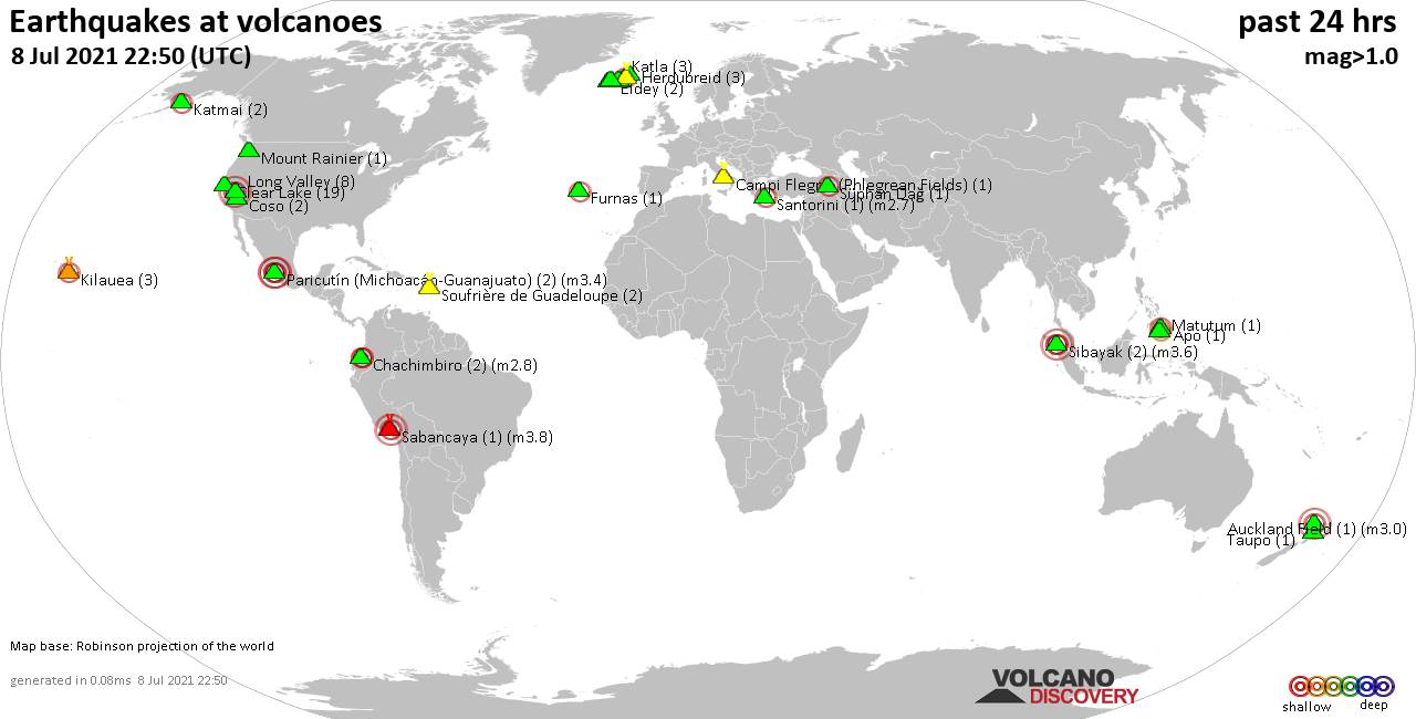
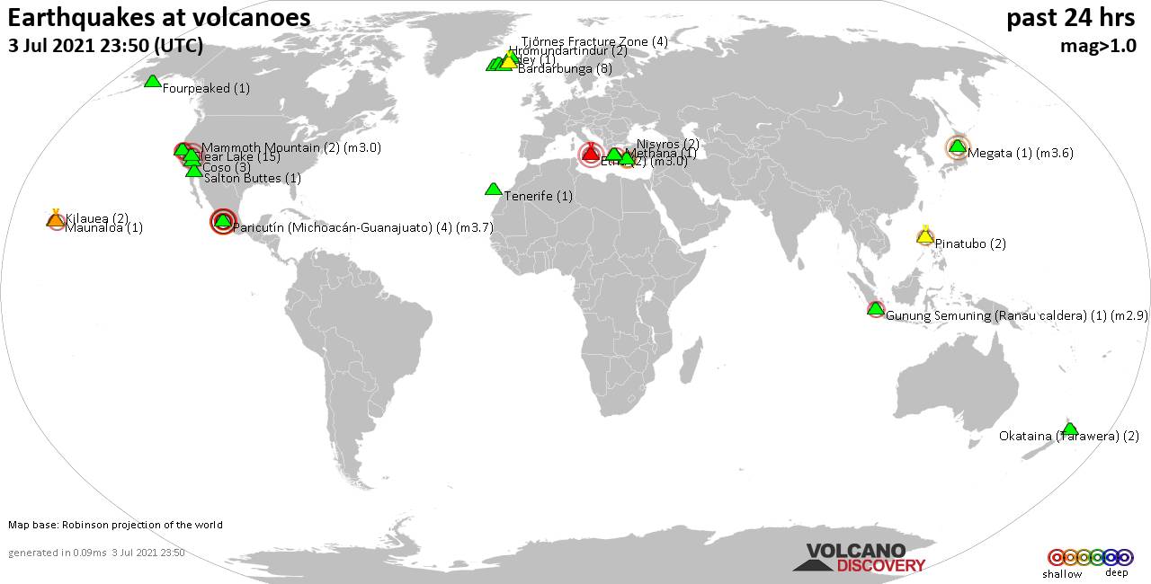
World map showing volcanoes with shallow (less than 20 km) earthquakes within 20 km radius during the past 24 hours on 11 Jul 2021 Number in brackets indicate nr of quakes.
Fourpeaked (1 quake mag 1.3), Hengill (1 quake mag 1.2), Herdubreid (10 quakes between mag 0.3-1.1), Iztaccíhuatl (1 quake mag 2.9), Kilauea (7 quakes between mag 1.7-2.5), Kiska (2 quakes between mag 5.1-5.3), Krísuvík (2 quakes between mag 0.7-1.2), Long Valley (2 quakes between mag 0.3-1.6), Mammoth Mountain (1 quake mag 1.1), Methana (1 quake mag 1.8), Ngauruhoe (1 quake mag 1.5), Okataina (Tarawera) (1 quake mag 2.1), Paco (1 quake mag 2.0), Pelée (2 quakes between mag 0.2-1.1), Ragang (1 quake mag 2.7), Reykjanes (36 quakes between mag 0.1-2.5), Sorikmarapi (1 quake mag 2.8), Sousaki (1 quake mag 1.9), Tenorio (1 quake mag 3.2), White Island (1 quake mag 2.1) (updated 23h50)
Note: Earthquakes within 20 km from and at depths less than 20 km under active volcanoes are reported. The list is not complete because many volcanoes are not monitored and/or seismic data in high resolution is not available publicly.
Volcanoes with recent earthquakes above magnitude 2 or more than 10 quakes are listed below:
Amboy volcano (California): magnitude 3.0 earthquake
A magnitude 3.0 earthquake occurred at the volcano 13 hours ago. The quake, which might be volcanic in origin, was located at a depth of 10.0 km depth at 14 km distance WNW from the volcano.Earthquake details:
Unconfirmed quake reported: 25 mi west of Ridgecrest, Kern County, California, USA, 11 July 2021 11:17 GMT (14 km WNW)
All earthquakes at Amboy
Clear Lake volcano (California): 19 earthquakes up to magnitude 2.4
Possible earthquake swarm: 19 earthquakes occurred near (under) the volcano during 21 hours, the last being recorded quake 2 hours ago. Hypocenter depths ranged between 3.4 and 0.5 km.Earthquake details: (only 5 largest)
2.4 quake 6km NW of The Geysers, CA, 11 July 2021 06:13 GMT (16 km S)
1.8 quake 6km NW of The Geysers, CA, 11 July 2021 06:53 GMT (16 km S)
1.5 quake 7km W of Cobb, CA, 11 July 2021 19:28 GMT (16 km S)
1.4 quake 7km WNW of The Geysers, CA, 11 July 2021 20:20 GMT (19 km SSW)
1.2 quake 12km WNW of The Geysers, CA, 11 July 2021 04:59 GMT (18 km SSW)
All earthquakes at Clear Lake
Coso volcano (California): 13 earthquakes up to magnitude 2.5
Possible earthquake swarm: 13 earthquakes occurred near (under) the volcano during 17 hours, the last being recorded quake 2 hours ago. Hypocenter depths ranged between 5.8 and 0.0 km.Earthquake details: (only 5 largest)
2.5 quake 9km NE of Coso Junction, CA, 11 July 2021 04:20 GMT (8 km NNW)
2.4 quake 20km E of Little Lake, CA, 11 July 2021 12:10 GMT (15 km SE)
1.6 quake 10km NE of Coso Junction, CA, 11 July 2021 06:21 GMT (11 km NNW)
1.4 quake 10km ENE of Coso Junction, CA, 11 July 2021 21:37 GMT (5 km NNW)
1.4 quake 10km NE of Coso Junction, CA, 11 July 2021 16:37 GMT (11 km NNW)
All earthquakes at Coso
Fort Portal volcano (Uganda): magnitude 3.0 earthquake
A magnitude 3.0 earthquake occurred at the volcano 17 hours ago. The quake, which might be volcanic in origin, was located at a depth of 10.0 km depth at 8 km distance SSE from the volcano.Earthquake details:
Unconfirmed quake reported: 3.3 km southeast of Fort Portal, Kabarole District, Western Region, Uganda, 11 July 2021 06:20 GMT (8 km SSE)
All earthquakes at Fort Portal
Iztaccíhuatl volcano (Western & Central Mexico): magnitude 2.9 earthquake
A magnitude 2.9 earthquake occurred at the volcano 1 hour 56 minutes ago. The quake, which might be volcanic in origin, was located at a depth of 2.0 km depth at 7 km distance SW from the volcano.Earthquake details:
2.9 quake 8.1 km east of Amecameca, México, Mexico, 2021-07-11 16:54:15 (Hora de México) (7 km SW)
All earthquakes at Iztaccíhuatl
Kilauea volcano (Hawai'i (Big Island)): 7 earthquakes up to magnitude 2.5
7 earthquakes occurred near (under) the volcano during 19 hours, the last being recorded quake 3 hours ago. Hypocenter depths ranged between 2.8 and 0.5 km.Earthquake details: (only 5 largest)
2.5 quake 7 Km S of Volcano, Hawaii, 11 July 2021 15:23 GMT (8 km ESE)
2.3 quake 7 Km SSE of Volcano, Hawaii, 11 July 2021 02:16 GMT (8 km ESE)
2.2 quake 11 Km S of Fern Forest, Hawaii, 11 July 2021 20:55 GMT (19 km ESE)
2.1 quake 6 Km SSW of Volcano, Hawaii, 11 July 2021 02:16 GMT (4 km SE)
1.7 quake 7 Km SSE of Volcano, Hawaii, 11 July 2021 08:53 GMT (9 km ESE)
All earthquakes at Kilauea
Kiska volcano (Aleutian Islands): 2 earthquakes up to magnitude 5.3
2 earthquakes occurred near (under) the volcano during 2 hours, the last being recorded quake 22 hours ago. Hypocenter depths ranged between 10.0 and 10.0 km.Earthquake details:
5.3 quake Bering Sea, 177 mi east of Attu Station, Aleutians West, Alaska, USA, 10 Jul 5:11 pm (GMT -9) (11 km W)
5.1 quake Bering Sea, 177 mi east of Attu Station, Aleutians West, Alaska, USA, 10 Jul 3:08 pm (GMT -9) (16 km NW)
All earthquakes at Kiska
Okataina (Tarawera) volcano (New Zealand): magnitude 2.1 earthquake
A magnitude 2.1 earthquake occurred at the volcano 21 hours ago. The quake, which might be volcanic in origin, was located at a depth of 5.0 km depth at 18 km distance ENE from the volcano.Earthquake details:
2.1 quake 2.3 km north of Kawerau, Bay of Plenty, New Zealand, 11 July 2021 03:16 GMT (18 km ENE)
All earthquakes at Okataina (Tarawera)
Ragang volcano (Mindanao): magnitude 2.7 earthquake
A magnitude 2.7 earthquake occurred at the volcano 14 hours ago. The quake, which might be volcanic in origin, was located at a depth of 1.0 km depth at 14 km distance ENE from the volcano.Earthquake details:
2.7 quake 7.3 km northwest of Wao, Philippines, 11 July 2021 - 05:40 PM (PST) (14 km ENE)
All earthquakes at Ragang
Reykjanes volcano (Reykjanes Peninsula, Iceland): 36 earthquakes up to magnitude 2.5
Possible earthquake swarm: 36 earthquakes occurred near (under) the volcano during 10 hours, the last being recorded quake 11 hours ago. Hypocenter depths ranged between 6.9 and 0.3 km.Earthquake details: (only 5 largest)
2.5 quake Iceland: 3.9 Km NNW of Grindavík 11 July 2021 08:55 GMT (3 km SE)
2.2 quake Iceland: 3.7 Km NNW of Grindavík 11 July 2021 08:41 GMT (3 km SE)
1.8 quake Iceland: 2.4 Km N of Reykjanestá 11 July 2021 08:48 GMT (12 km SW)
1.7 quake Iceland: 3.6 Km N of Reykjanestá 11 July 2021 01:56 GMT (11 km SW)
1.5 quake Iceland: 4.1 Km N of Grindavík 11 July 2021 04:37 GMT (4 km ESE)
All earthquakes at Reykjanes
Sorikmarapi volcano (Sumatra): magnitude 2.8 earthquake
A magnitude 2.8 earthquake occurred at the volcano 20 hours ago. The quake, which might be volcanic in origin, was located at a depth of 10.0 km depth at 18 km distance N from the volcano.Earthquake details:
2.8 quake 67 km southeast of Padangsidempuan, North Sumatra, Indonesia, 11 July 2021 03:47 GMT (18 km N)
All earthquakes at Sorikmarapi
Tenorio volcano (Costa Rica): magnitude 3.2 earthquake
A magnitude 3.2 earthquake occurred at the volcano 5 hours ago. The quake, which might be volcanic in origin, was located at a depth of 9.0 km depth at 2 km distance S from the volcano.Earthquake details:
3.2 quake 27 km north of Canas, Cañas, Provincia de Guanacaste, Costa Rica, 11 de julio del 2021 12:49 am (2 km S)
All earthquakes at Tenorio
White Island volcano (New Zealand): magnitude 2.1 earthquake
A magnitude 2.1 earthquake occurred at the volcano 13 hours ago. The quake, which might be volcanic in origin, was located at a depth of 5.0 km depth at 17 km distance NNW from the volcano.Earthquake details:
2.1 quake South Pacific Ocean, 92 km northeast of Tauranga, Bay of Plenty, New Zealand, 11 July 2021 11:19 GMT (17 km NNW)
All earthquakes at White Island
Previous news
Sat, 10 Jul 2021, 23:50
Volcano earthquake report for Saturday, 10 Jul 2021
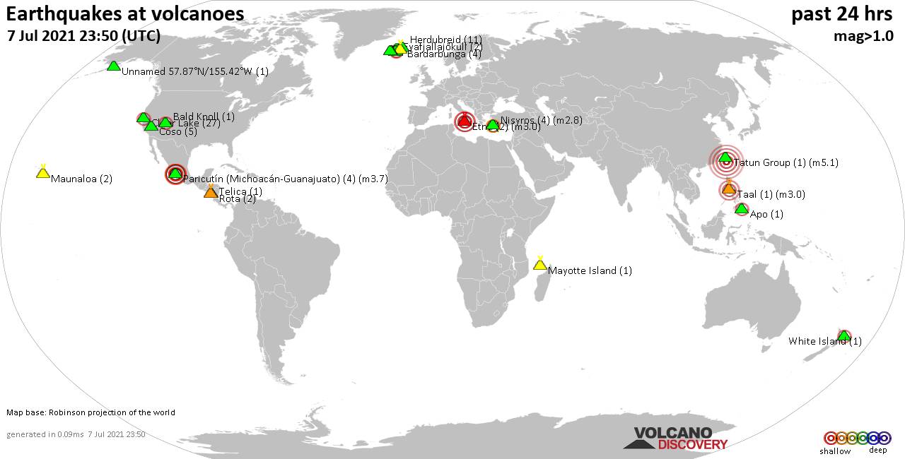
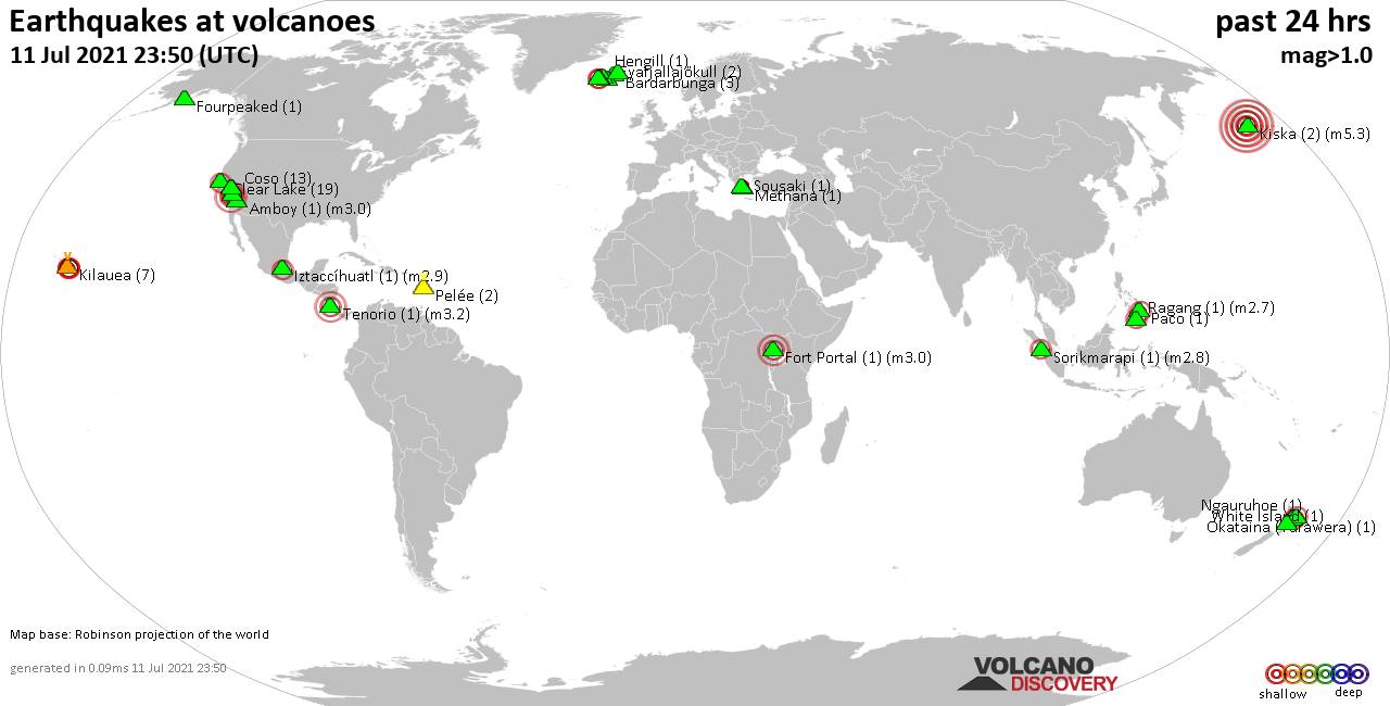
Quakes detected near: Bardarbunga (6 quakes between mag 0.2-1.2), Brennisteinsfjöll (24 quakes between mag 0.1-1.4), Clear Lake (22 quakes between mag 0.4-2.3), Coso (5 quakes between mag 0.5-1.4), Etna (2 quakes between mag 3.0-3.0), Eyafjallajökull (1 quake mag 1.2) ... Read all
Fri, 9 Jul 2021, 23:50
Volcano earthquake report for Friday, 9 Jul 2021
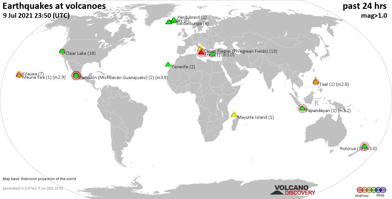
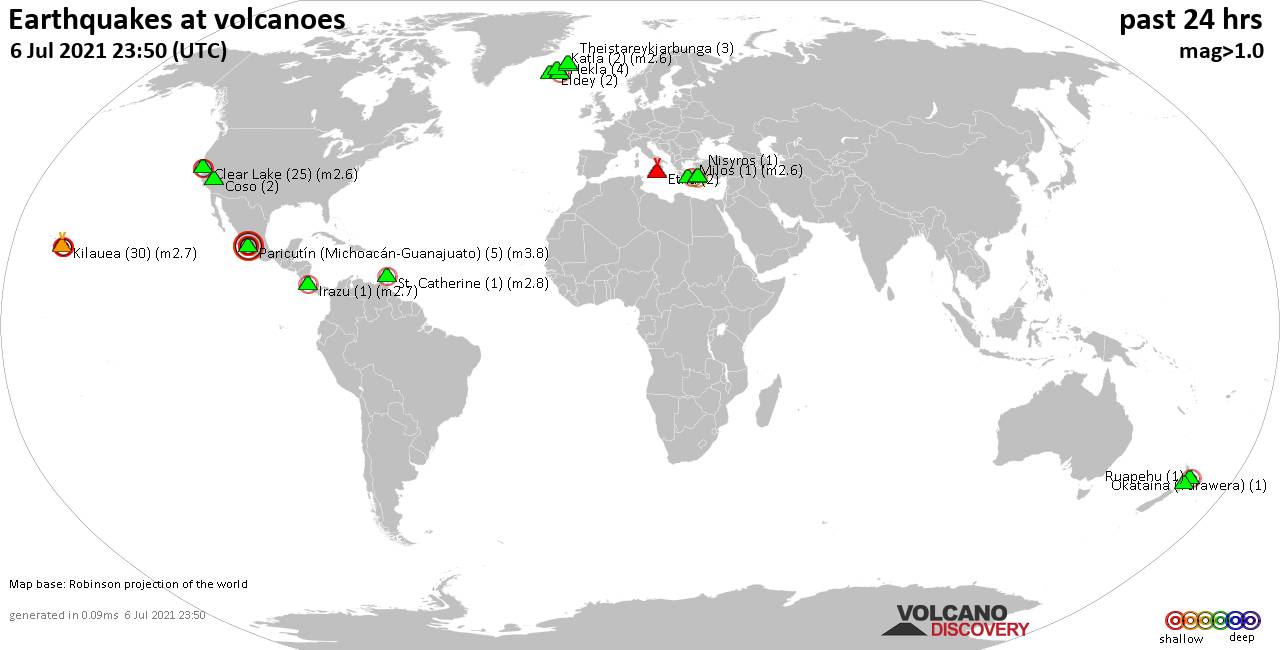
Quakes detected near: Bardarbunga (4 quakes between mag 0.3-1.1), Brennisteinsfjöll (7 quakes between mag 0.1-1.2), Campi Flegrei (Phlegrean Fields) (13 quakes between mag 0.2-1.3), Clear Lake (18 quakes between mag 0.3-2.2), Eldey (6 quakes between mag 0.6-1.4), Etna (1 quake mag 3.0) ... Read all
Show more