Volcano earthquake report for Monday, 4 Mar 2019
Mon, 4 Mar 2019, 23:50 | BY: EARTHQUAKEMONITOR

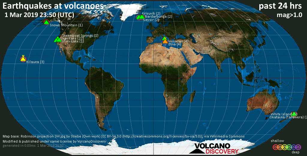
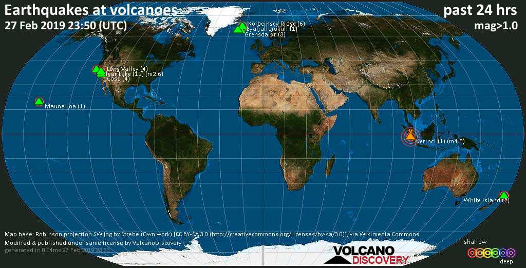
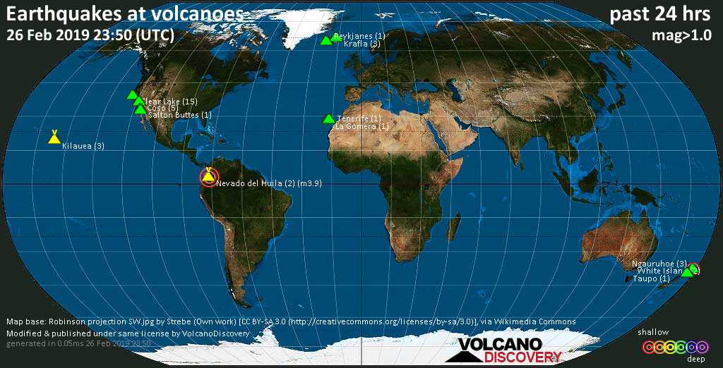
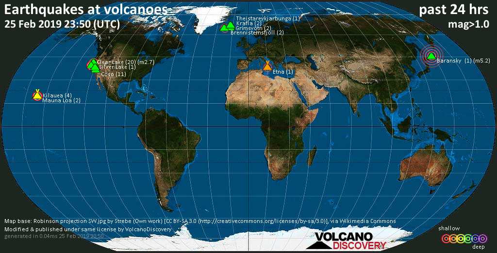
World map showing volcanoes with shallow (less than 20 km) earthquakes within 20 km radius during the past 24 hours on 4 Mar 2019 Number in brackets indicate nr of quakes.
Etna (1 quake mag 2.6), Grímsvötn (4 quakes between mag 0.9-1.4), Kilauea (1 quake mag 1.8), Mauna Loa (2 quakes between mag 1.8-2.8), Mono Lake (1 quake mag 1.6), Mount St. Helens (1 quake mag 1.4), Reykjanes (1 quake mag 1.3), Ruapehu (1 quake mag 1.9), Salton Buttes (3 quakes between mag 1.1-1.7), Spurr (1 quake mag 1.4), Taupo (1 quake mag 1.7), Ukinrek Maars (1 quake mag 1.4), West Crater (1 quake mag 1.1) (updated 23h50)
Note: Earthquakes within 20 km from and at depths less than 20 km under active volcanoes are reported. The list is not complete because many volcanoes are not monitored and/or seismic data in high resolution is not available publicly.
Volcanoes with recent earthquakes above magnitude 2 or more than 10 quakes are listed below:
Akyarlar volcano (Turkey): magnitude 2.3 earthquake
A magnitude 2.3 earthquake occurred at the volcano 16 hours ago. The quake, which might be volcanic in origin, was located at a depth of 4.5 km depth at 11 km distance W from the volcano.Earthquake details:
M 2.3 quake: BODRUM (MUGLA) (Turkey) on Mon, 4 Mar 07h28 (11 km W)
All earthquakes at Akyarlar
Bardarbunga volcano (Iceland): 14 earthquakes up to magnitude 4.1
Possible earthquake swarm: 14 earthquakes occurred near (under) the volcano during 10 hours, the last being recorded quake 8 hours ago. Hypocenter depths ranged between 10.0 and 0.1 km.Earthquake details: (only 5 largest)
M 4.1 quake: 5.9 km SE of Bárðarbunga (Iceland) on Mon, 4 Mar 05h52 (6 km SSE)
M 3.8 quake: 5.7 km ESE of Bárðarbunga (Iceland) on Mon, 4 Mar 05h46 (5 km ESE)
M 3.3 quake: 4.6 km ESE of Bárðarbunga (Iceland) on Mon, 4 Mar 06h03 (4 km ESE)
M 2.8 quake: 5.7 km ESE of Bárðarbunga (Iceland) on Mon, 4 Mar 05h46 (5 km ESE)
M 2.3 quake: 5.5 km ESE of Bárðarbunga (Iceland) on Mon, 4 Mar 06h03 (5 km ESE)
All earthquakes at Bardarbunga
Caichinque volcano (Northern Chile, Bolivia and Argentina): magnitude 2.9 earthquake
A magnitude 2.9 earthquake occurred at the volcano 15 hours ago. The quake, which might be volcanic in origin, was located at a depth of 10.0 km depth at 6 km distance NW from the volcano.Earthquake details:
M 2.9 quake: 43 km al SE de Socaire (Chile) on Mon, 4 Mar 08h21 (6 km NW)
All earthquakes at Caichinque
Clear Lake volcano (California): 23 earthquakes up to magnitude 2.4
Possible earthquake swarm: 23 earthquakes occurred near (under) the volcano during 19 hours, the last being recorded quake 2 hours ago. Hypocenter depths ranged between 12.1 and 0.2 km.Earthquake details: (only 5 largest)
M 2.4 quake: NORTHERN CALIFORNIA (USA) on Mon, 4 Mar 20h53 (17 km S)
M 1.9 quake: 10km NW of The Geysers, CA (USA) on Mon, 4 Mar 11h33 (16 km SSE)
M 1.4 quake: 6km NW of The Geysers, CA (USA) on Mon, 4 Mar 08h43 (18 km S)
M 1.2 quake: 7km NW of The Geysers, CA (USA) on Mon, 4 Mar 21h37 (17 km S)
M 1.2 quake: 3km NW of Cobb, CA (USA) on Mon, 4 Mar 14h11 (14 km S)
All earthquakes at Clear Lake
Etna volcano (Italy): magnitude 2.6 earthquake
A magnitude 2.6 earthquake occurred at the volcano 5 hours ago. The quake, which might be volcanic in origin, was located at a depth of 1.3 km depth at 12 km distance SSE from the volcano.Earthquake details:
M 2.6 quake: 3 km NE Ragalna (CT) (Italy) on Mon, 4 Mar 18h35 (12 km SSE)
All earthquakes at Etna
Mauna Loa volcano (Hawai'i (Big Island)): 2 earthquakes up to magnitude 2.8
2 earthquakes occurred near (under) the volcano during 3 hours, the last being recorded quake 18 hours ago. Hypocenter depths ranged between 0.4 and 0.0 km.Earthquake details:
M 2.8 quake: ISLAND OF HAWAII, HAWAII (USA) on Mon, 4 Mar 02h41 (5 km S)
M 1.8 quake: 26km E of Honaunau-Napoopoo, Hawaii (USA) on Mon, 4 Mar 05h39 (4 km S)
All earthquakes at Mauna Loa
Previous news


Show more