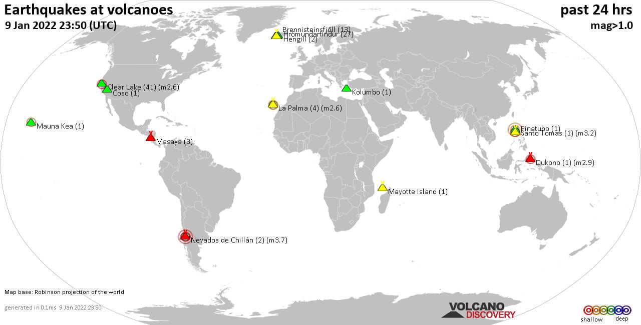
Volcano earthquake report for Saturday, 15 Jan 2022
Sat, 15 Jan 2022, 23:50 | BY: EARTHQUAKEMONITOR
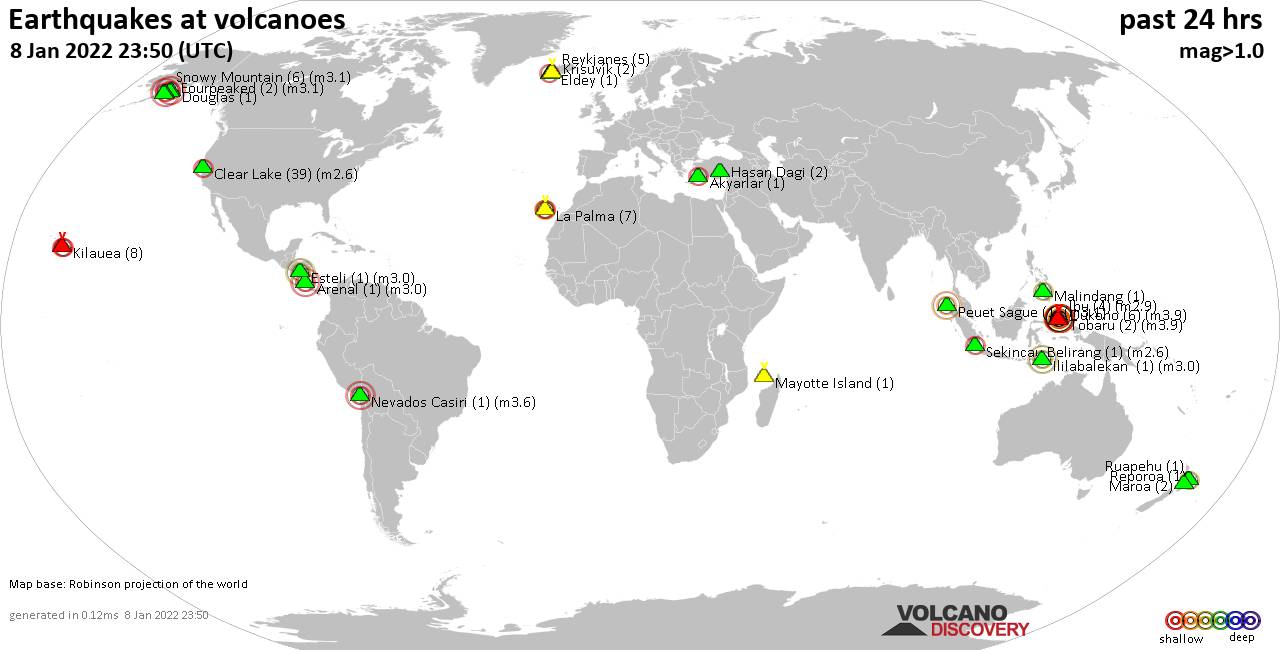
World map showing volcanoes with shallow (less than 50 km) earthquakes within 20 km radius during the past 24 hours on 15 Jan 2022 Number in brackets indicate nr of quakes.
Chichinautzin (1 quake mag 2.3), Clear Lake (33 quakes between mag 0.4-2.0), Coatepeque (4 quakes between mag 1.8-3.0), Coso (7 quakes between mag 1.0-1.4), Eldey (1 quake mag 1.5), Fagradalsfjall (15 quakes between mag 0.3-1.3), Girekol (2 quakes between mag 2.8-3.2), Grímsnes (7 quakes between mag 0.1-1.0), Hunga Tonga-Hunga Ha'apai (3 quakes between mag 1.0-5.8), Ilopango (1 quake mag 2.3), Katla (6 quakes between mag 0.4-1.6), Kolumbo (1 quake mag 2.1), Krísuvík (32 quakes between mag 0.1-1.5), La Palma (13 quakes between mag 1.4-2.4), Maroa (4 quakes between mag 1.5-2.6), Mauna Kea (1 quake mag 2.1), Maunaloa (2 quakes between mag 1.8-2.1), Mayotte Island (3 quakes between mag 1.0-2.0), Prestahnukur (3 quakes between mag 1.1-1.7), Reporoa (1 quake mag 1.9), Ruapehu (7 quakes between mag 0.7-2.1), Tenerife (1 quake mag 1.0), Tinguiririca (1 quake mag 3.0), Tjörnes Fracture Zone (2 quakes between mag 1.1-1.5) (updated 23h50)
Note: Earthquakes within 20 km from and at depths less than 50 km under active volcanoes are reported. The list is not complete because many volcanoes are not monitored and/or seismic data in high resolution is not available publicly.
Volcanoes with recent earthquakes above magnitude 2 or more than 10 quakes are listed below:
Akuseki-jima volcano (Ryukyu Islands): magnitude 3.2 earthquake
A magnitude 3.2 earthquake occurred at the volcano 13 hours ago. The quake, which might be volcanic in origin, was located at a depth of 9.4 km depth at 15 km distance W from the volcano.Earthquake details:
3.2 quake East China Sea, Japan, Jan 15, 2022 7:55 pm (GMT +9) (15 km W)
All earthquakes at Akuseki-jima
Auckland Field volcano (North Island): magnitude 3.0 earthquake
A magnitude 3.0 earthquake occurred at the volcano 5 hours ago. The quake, which might be volcanic in origin, was located at a depth of 10.0 km depth at 12 km distance WSW from the volcano.Earthquake details:
Reported seismic-like event (likely no quake): akland, Auckland, New Zealand, Jan 16, 2022 7:59 am (GMT +13) (12 km WSW)
All earthquakes at Auckland Field
Cerro Singüil volcano (El Salvador): 2 earthquakes up to magnitude 3.1
2 earthquakes occurred near (under) the volcano during 33 minutes, the last being recorded quake 21 hours ago. Hypocenter depths ranged between 5.0 and 4.0 km.Earthquake details:
3.1 quake Jerez, Departamento de Jutiapa, 103 km southeast of Guatemala, Departamento de Guatemala, Jan 14, 2022 8:12 pm (GMT -6) (11 km WNW)
3.0 quake 21 km northwest of Santa Ana, El Salvador, Jan 14, 2022 8:45 pm (GMT -6) (10 km NW)
All earthquakes at Cerro Singüil
Chichinautzin volcano (Western & Central Mexico): magnitude 2.3 earthquake
A magnitude 2.3 earthquake occurred at the volcano 15 hours ago. The quake, which might be volcanic in origin, was located at a depth of 21.0 km depth at 15 km distance ENE from the volcano.Earthquake details:
2.3 quake Milpa Alta Borough, 35 km southeast of Mexico, Jan 15, 2022 2:52 am (GMT -6) (15 km ENE)
All earthquakes at Chichinautzin
Clear Lake volcano (California): 33 earthquakes up to magnitude 2.0
Possible earthquake swarm: 33 earthquakes occurred near (under) the volcano during 22 hours, the last being recorded quake 1 hour 53 minutes ago. Hypocenter depths ranged between 3.3 and 0.0 km.Earthquake details: (only 5 largest)
2.0 quake 3km NNW of The Geysers, CA, Jan 14, 2022 9:25 pm (GMT -8) (19 km S)
1.9 quake 6km NNW of The Geysers, CA, Jan 15, 2022 6:51 am (GMT -8) (17 km S)
1.7 quake 5km W of Cobb, CA, Jan 15, 2022 12:01 am (GMT -8) (16 km S)
1.7 quake 8km NW of Cobb, CA, Jan 15, 2022 7:21 am (GMT -8) (11 km S)
1.4 quake 10km WNW of The Geysers, CA, Jan 15, 2022 5:07 am (GMT -8) (18 km SSW)
All earthquakes at Clear Lake
Coatepeque volcano (El Salvador): 4 earthquakes up to magnitude 3.0
4 earthquakes occurred near (under) the volcano during 15 hours, the last being recorded quake 1 hour 7 minutes ago. Hypocenter depths ranged between 13.0 and 5.0 km.Earthquake details:
3.0 quake Departamento de La Libertad, 30 km west of San Salvador, El Salvador, Jan 15, 2022 4:30 pm (GMT -6) (15 km SE)
2.9 quake 21 km northwest of Santa Tecla, Departamento de La Libertad, El Salvador, Jan 15, 2022 4:31 pm (GMT -6) (16 km SE)
2.3 quake Departamento de La Libertad, 28 km west of San Salvador, El Salvador, Jan 15, 2022 4:42 pm (GMT -6) (16 km SE)
1.8 quake Departamento de Sonsonate, 32 km west of San Salvador, El Salvador, Jan 15, 2022 1:16 am (GMT -6) (13 km SE)
All earthquakes at Coatepeque
Fagradalsfjall volcano (Reykjanes Peninsula, Iceland): 15 earthquakes up to magnitude 1.3
Possible earthquake swarm: 15 earthquakes occurred near (under) the volcano during 20 hours, the last being recorded quake 1 hour 41 minutes ago. Hypocenter depths ranged between 7.3 and 3.6 km.Earthquake details: (only 5 largest)
1.3 quake Iceland: 2.4 Km E of Fagradalsfjall Jan 15, 2022 6:38 am (GMT +0) (2 km ENE)
1.0 quake Iceland: 2.1 Km SE of Fagradalsfjall Jan 15, 2022 8:12 am (GMT +0) (1 km E)
1.0 quake Iceland: 4.3 Km NE of Grindavík Jan 15, 2022 2:31 am (GMT +0) (6 km WSW)
0.9 quake Iceland: 0.7 Km E of Fagradalsfjall Jan 15, 2022 2:36 pm (GMT +0) (1 km NNE)
0.8 quake Iceland: 0.9 Km SSE of Fagradalsfjall Jan 15, 2022 11:53 am (GMT +0) (0 km NE)
All earthquakes at Fagradalsfjall
Girekol volcano (Turkey): 2 earthquakes up to magnitude 3.2
2 earthquakes occurred near (under) the volcano during 4 hours, the last being recorded quake 18 hours ago. Hypocenter depths ranged between 2.0 and 0.0 km.Earthquake details:
3.2 quake 71 km north of Van, Turkey, Jan 15, 2022 8:33 am (GMT +3) (14 km SSW)
2.8 quake 69 km north of Van, Turkey, Jan 15, 2022 4:37 am (GMT +3) (14 km SSW)
All earthquakes at Girekol
Hunga Tonga-Hunga Ha'apai volcano (Tonga): 3 earthquakes up to magnitude 5.8
3 earthquakes occurred near (under) the volcano during 12 minutes, the last being recorded quake 19 hours ago. Hypocenter depths ranged between 33.0 and 0.0 km.Earthquake details:
5.8 quake South Pacific Ocean, Tonga, Jan 15, 2022 5:14 pm (GMT +13) (3 km NNW)
4.0 quake South Pacific Ocean, Tonga, Jan 15, 2022 5:26 pm (GMT +13) (3 km N)
1.0 quake 73 Km NNW of Nuku'alofa, Tonga, Jan 15, 2022 5:26 pm (GMT +13) (8 km NNW)
All earthquakes at Hunga Tonga-Hunga Ha'apai
Ilopango volcano (El Salvador): magnitude 2.3 earthquake
A magnitude 2.3 earthquake occurred at the volcano 17 hours ago. The quake, which might be volcanic in origin, was located at a depth of 5.0 km depth at 19 km distance N from the volcano.Earthquake details:
2.3 quake Departamento de Cuscatlan, 22 km northeast of San Salvador, El Salvador, Jan 15, 2022 1:16 am (GMT -6) (19 km N)
All earthquakes at Ilopango
Kolumbo volcano (Greece): magnitude 2.1 earthquake
A magnitude 2.1 earthquake occurred at the volcano 15 hours ago. The quake, which might be volcanic in origin, was located at a depth of 5.0 km depth at 7 km distance W from the volcano.Earthquake details:
2.1 quake Aegean Sea, 36 km northwest of Anaphi Island, Greece, Jan 15, 2022 10:38 am (GMT +2) (7 km W)
All earthquakes at Kolumbo
Krísuvík volcano (Reykjanes Peninsula, Iceland): 32 earthquakes up to magnitude 1.5
Possible earthquake swarm: 32 earthquakes occurred near (under) the volcano during 16 hours, the last being recorded quake 8 hours ago. Hypocenter depths ranged between 8.2 and 0.1 km.Earthquake details: (only 5 largest)
1.5 quake Iceland: 3.1 Km WNW of Krýsuvík Jan 15, 2022 1:24 am (GMT +0) (4 km SSW)
1.3 quake Iceland: 4.0 Km WNW of Krýsuvík Jan 15, 2022 2:18 am (GMT +0) (4 km SSW)
1.3 quake Iceland: 4.0 Km WNW of Krýsuvík Jan 15, 2022 5:00 am (GMT +0) (4 km SSW)
1.1 quake Iceland: 3.3 Km WNW of Krýsuvík Jan 15, 2022 12:09 am (GMT +0) (4 km SSW)
1.0 quake Iceland: 7.1 Km NNE of Krýsuvík Jan 15, 2022 4:32 am (GMT +0) (5 km ENE)
All earthquakes at Krísuvík
La Palma volcano (Canary Islands): 13 earthquakes up to magnitude 2.4
Possible earthquake swarm: 13 earthquakes occurred near (under) the volcano during 20 hours, the last being recorded quake 4 hours ago. Hypocenter depths ranged between 15.0 and 8.0 km.Earthquake details: (only 5 largest)
2.4 quake La Palma Island, Canary Islands, Spain, Jan 15, 2022 10:20 am (GMT +0) (4 km SE)
2.3 quake La Palma Island, Canary Islands, Spain, Jan 15, 2022 8:31 am (GMT +0) (2 km S)
2.0 quake La Palma Island, Canary Islands, Spain, Jan 15, 2022 3:18 pm (GMT +0) (3 km SSE)
1.9 quake La Palma Island, Canary Islands, Spain, Jan 15, 2022 11:28 am (GMT +0) (2 km S)
1.9 quake La Palma Island, Canary Islands, Spain, Jan 15, 2022 4:55 am (GMT +0) (3 km E)
All earthquakes at La Palma
Maroa volcano (New Zealand): 4 earthquakes up to magnitude 2.6
4 earthquakes occurred near (under) the volcano during 18 minutes, the last being recorded quake 2 hours ago. Hypocenter depths ranged between 5.6 and 3.9 km.Earthquake details:
2.6 quake Rotorua District, Bay of Plenty, New Zealand, Jan 16, 2022 10:24 am (GMT +13) (10 km ENE)
1.9 quake Rotorua District, Bay of Plenty, New Zealand, Jan 16, 2022 10:21 am (GMT +13) (10 km ENE)
1.7 quake Rotorua District, Bay of Plenty, New Zealand, Jan 16, 2022 10:20 am (GMT +13) (12 km ENE)
1.5 quake Rotorua District, Bay of Plenty, New Zealand, Jan 16, 2022 10:38 am (GMT +13) (10 km ENE)
All earthquakes at Maroa
Mauna Kea volcano (Hawai'i (Big Island)): magnitude 2.1 earthquake
A magnitude 2.1 earthquake occurred at the volcano 21 hours ago. The quake, which might be volcanic in origin, was located at a depth of 11.3 km depth at 16 km distance N from the volcano.Earthquake details:
2.1 quake 11 Km SW of Pa'auilo, Hawaii, Jan 14, 2022 4:46 pm (GMT -10) (16 km N)
All earthquakes at Mauna Kea
Maunaloa volcano (Hawai'i (Big Island)): 2 earthquakes up to magnitude 2.1
2 earthquakes occurred near (under) the volcano during 54 minutes, the last being recorded quake 6 hours ago. Hypocenter depths ranged between 3.7 and 0.3 km.Earthquake details:
2.1 quake 27 Km NNW of Pāhala, Hawaii, Jan 15, 2022 8:13 am (GMT -10) (5 km SSE)
1.8 quake 22 Km ENE of Honaunau-Napoopoo, Hawaii, Jan 15, 2022 7:20 am (GMT -10) (6 km WNW)
All earthquakes at Maunaloa
Ruapehu volcano (North Island): 7 earthquakes up to magnitude 2.1
7 earthquakes occurred near (under) the volcano during 19 hours, the last being recorded quake 1 hour 59 minutes ago. Hypocenter depths ranged between 16.6 and 2.1 km.Earthquake details: (only 5 largest)
2.1 quake Ruapehu District, Manawatu-Wanganui, 236 km north of Wellington, New Zealand, Jan 15, 2022 4:05 pm (GMT +13) (18 km WNW)
1.3 quake New Zealand Jan 15, 2022 6:37 pm (GMT +13) (17 km WNW)
1.2 quake New Zealand Jan 15, 2022 9:21 pm (GMT +13) (16 km WNW)
0.9 quake New Zealand Jan 16, 2022 10:50 am (GMT +13) (17 km WNW)
0.9 quake New Zealand Jan 16, 2022 5:17 am (GMT +13) (17 km WNW)
All earthquakes at Ruapehu
Tinguiririca volcano (Central Chile and Argentina): magnitude 3.0 earthquake
A magnitude 3.0 earthquake occurred at the volcano 18 hours ago. The quake, which might be volcanic in origin, was located at a depth of 40.0 km depth at 13 km distance SE from the volcano.Earthquake details:
3.0 quake MENDOZA (Argentina) Jan 15, 2022 3:13 am (GMT -3) (13 km SE)
All earthquakes at Tinguiririca
Previous news
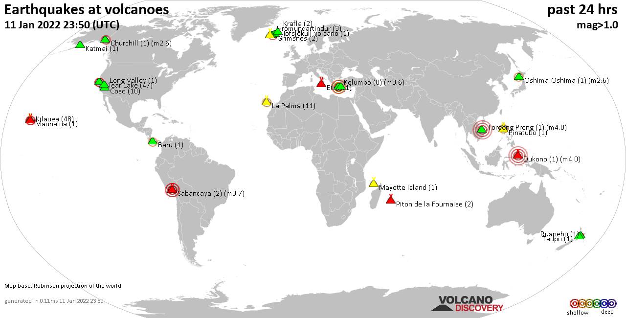
Fri, 14 Jan 2022, 23:50
Volcano earthquake report for Friday, 14 Jan 2022

Quakes detected near: Atka (1 quake mag 1.4), Baru (1 quake mag 2.6), Campi Flegrei (Phlegrean Fields) (1 quake mag 1.0), Cerro del Azufre (1 quake mag 3.6), Clear Lake (38 quakes between mag 0.4-2.6), Coso (13 quakes between mag 0.2-1.6) ... Read all
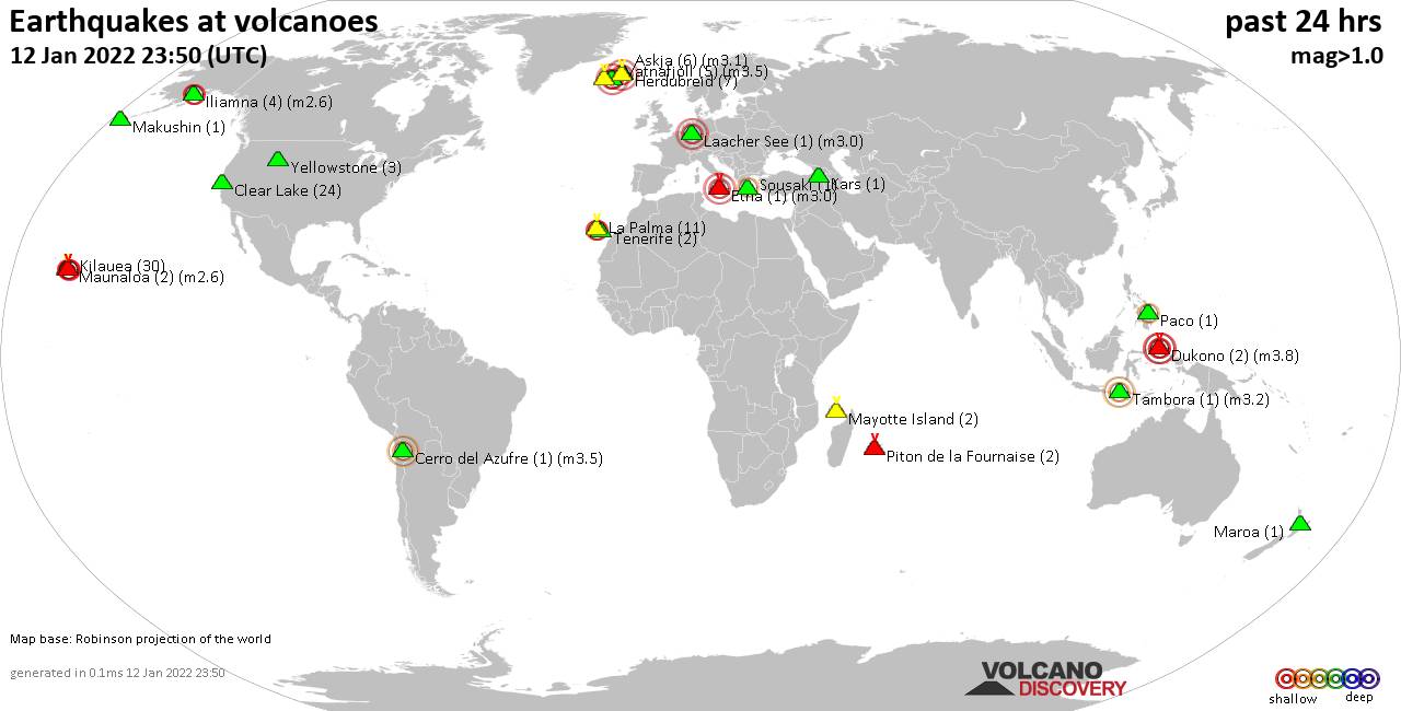
Thu, 13 Jan 2022, 23:50
Volcano earthquake report for Thursday, 13 Jan 2022

Quakes detected near: Antofagasta de la Sierra (1 quake mag 2.6), Bardarbunga (1 quake mag 3.2), Buzzard Creek (1 quake mag 1.8), Campi Flegrei (Phlegrean Fields) (3 quakes between mag 1.5-3.0), Clear Lake (21 quakes between mag 0.2-1.2), Coso (10 quakes between mag 0.5-1.9) ... Read all
Show more