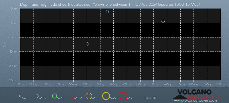
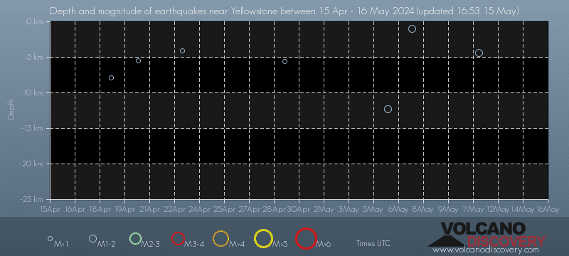
Date and Time | Mag Depth | Distance | Location | Details | Map |
|---|---|---|---|---|---|
| Apr 23, 12:04 am (Denver) | 0.8 4.1 km | 6.7 km (4.2 mi) to the E | Info | ||
| Saturday, April 20, 2024 GMT (1 quake) | |||||
| Apr 20, 05:27 am (Denver) | 0.3 5.5 km | 17 km (10.3 mi) to the N | Info | ||
| Thursday, April 18, 2024 GMT (1 quake) | |||||
| Apr 18, 01:38 pm (Denver) | 0.8 7.9 km | 23 km (14 mi) to the W | Info | ||
| Thursday, April 11, 2024 GMT (1 quake) | |||||
| Apr 11, 04:17 pm (Denver) | 1.3 1.6 km | 21 km (13 mi) to the N | Info | ||
| Sunday, April 7, 2024 GMT (3 quakes) | |||||
| Apr 7, 05:59 am (Denver) | 0.8 7.7 km | 24 km (15 mi) to the W | Info | ||
| Apr 7, 05:58 am (Denver) | 0.3 10.1 km | 23 km (14 mi) to the W | Info | ||
| Apr 7, 05:57 am (GMT -6) | 0.0 4 km | 24 km (15 mi) to the W | Info | ||
| Saturday, April 6, 2024 GMT (2 quakes) | |||||
| Apr 5, 11:06 pm (Denver) | 0.2 3.5 km | 15 km (9.6 mi) to the N | Info | ||
| Apr 5, 11:02 pm (Denver) | 0.9 7.1 km | 16 km (10.1 mi) to the N | Info | ||
| Sunday, March 31, 2024 GMT (1 quake) | |||||
| Mar 31, 09:13 am (Denver) | 0.7 3.5 km | 13 km (8.2 mi) to the SW | Info | ||
| Thursday, March 28, 2024 GMT (1 quake) | |||||
| Mar 28, 07:48 am (Denver) | 0.1 4.9 km | 27 km (17 mi) to the N | Info | ||
| or | ||
Look up quakes! | ||