Volcano earthquake report for Sunday, 1 Nov 2020
Sun, 1 Nov 2020, 23:50 | BY: EARTHQUAKEMONITOR
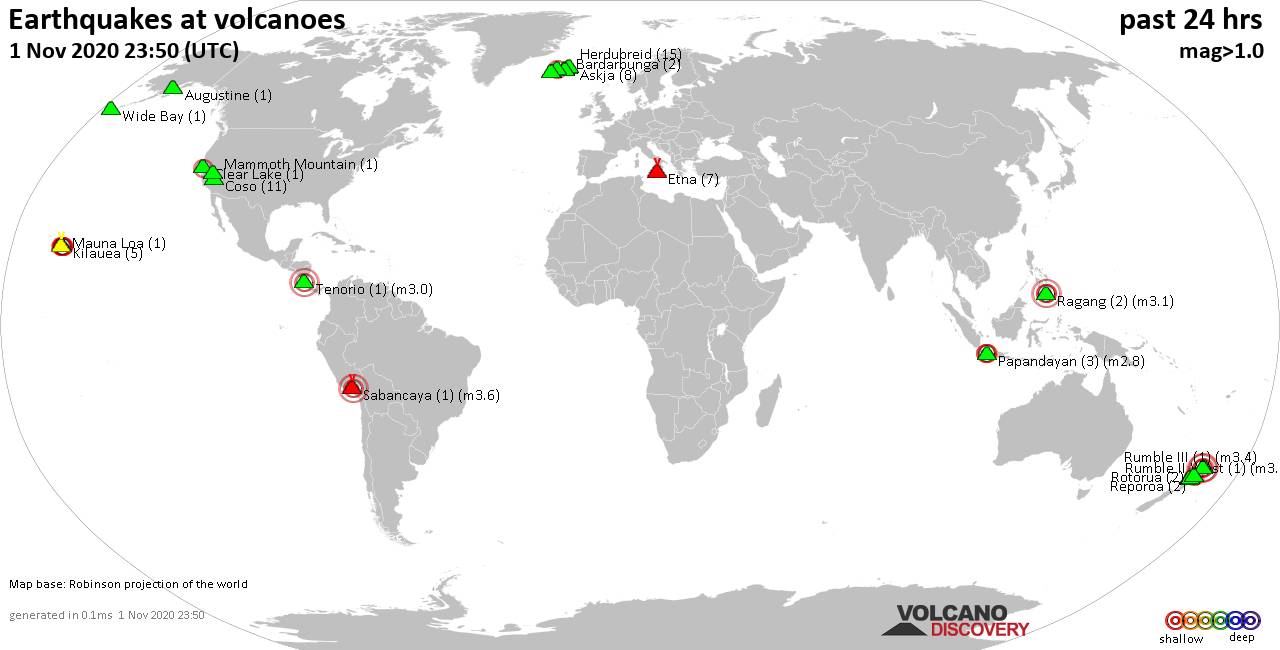
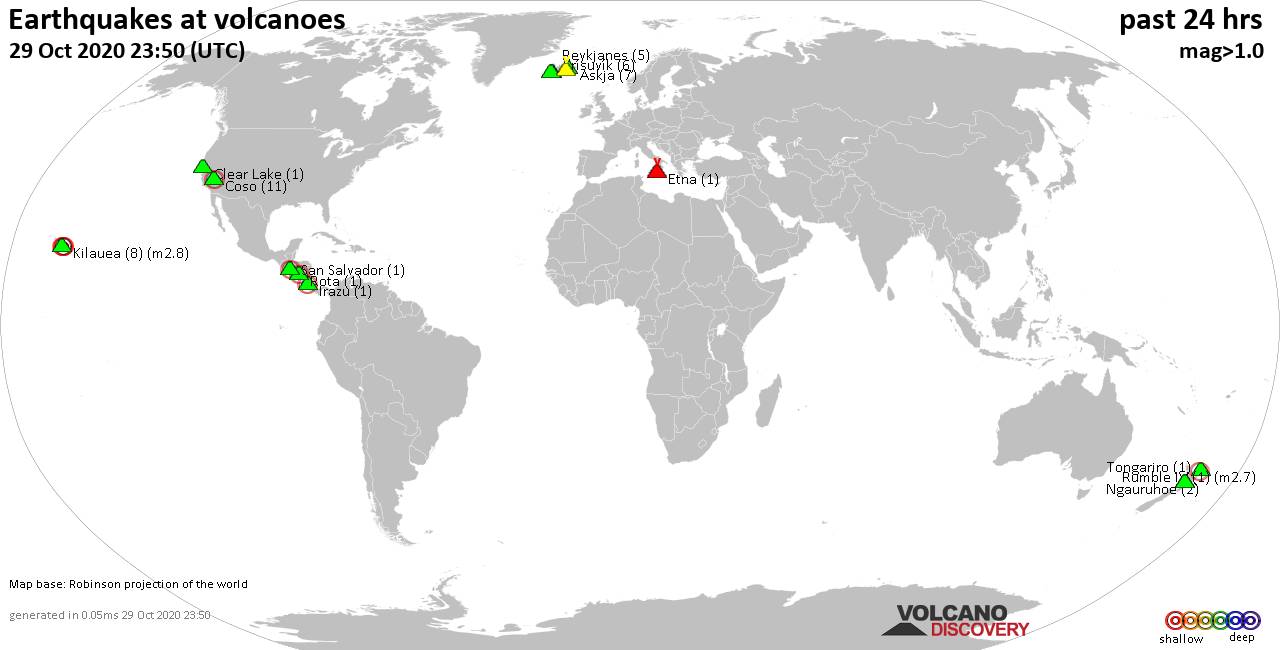
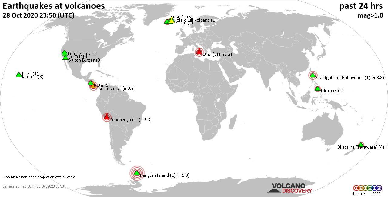
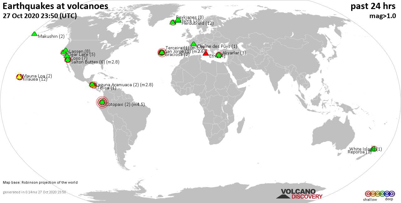
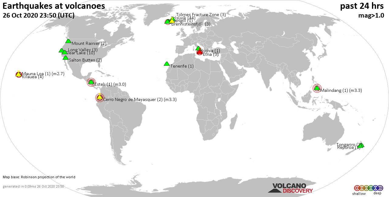
World map showing volcanoes with shallow (less than 20 km) earthquakes within 20 km radius during the past 24 hours on 1 Nov 2020 Number in brackets indicate nr of quakes.
Herdubreid (15 quakes between mag 0.4-1.7), Kilauea (5 quakes between mag 1.8-2.3), Krísuvík (10 quakes between mag 0.3-1.4), Loki-Fögrufjöll volcano (1 quake mag 1.1), Mammoth Mountain (1 quake mag 1.6), Mauna Loa (1 quake mag 2.4), Papandayan (3 quakes between mag 2.1-2.8), Prestahnukur (3 quakes between mag 1.4-2.0), Ragang (2 quakes between mag 2.5-3.1), Reporoa (2 quakes between mag 1.3-1.8), Reykjanes (15 quakes between mag 0.1-1.5), Rotorua (2 quakes between mag 1.5-1.6), Rumble II West (1 quake mag 3.6), Rumble III (1 quake mag 3.4), Sabancaya (1 quake mag 3.6), Tenorio (1 quake mag 3.0), White Island (1 quake mag 2.3), Wide Bay (1 quake mag 1.4) (updated 23h50)
Note: Earthquakes within 20 km from and at depths less than 20 km under active volcanoes are reported. The list is not complete because many volcanoes are not monitored and/or seismic data in high resolution is not available publicly.
Volcanoes with recent earthquakes above magnitude 2 or more than 10 quakes are listed below:
Clear Lake volcano (California): magnitude 2.1 earthquake
A magnitude 2.1 earthquake occurred at the volcano 8 hours ago. The quake, which might be volcanic in origin, was located at a depth of 0.3 km depth at 19 km distance S from the volcano.Earthquake details:
2.1 quake 14 miles SW of Clearlake 1 Nov 8.15 am (GMT -8) (19 km S)
All earthquakes at Clear Lake
Coso volcano (California): 11 earthquakes up to magnitude 1.8
Possible earthquake swarm: 11 earthquakes occurred near (under) the volcano during 23 hours, the last being recorded quake 1 hour 5 minutes ago. Hypocenter depths ranged between 9.8 and 1.3 km.Earthquake details: (only 5 largest)
1.8 quake 15 miles SSE of Olancha, California, 1 Nov 5.32 am (GMT -8) (8 km NW)
1.3 quake 31 miles NNW of China Lake Acres, California, 1 Nov 1.13 pm (GMT -8) (7 km NW)
1.2 quake 23 miles N of Ridgecrest, California, 1 Nov 9.20 am (GMT -8) (16 km ESE)
1.1 quake 10.8 miles SSE of Olancha, California, 1 Nov 5.03 am (GMT -8) (17 km NW)
1.1 quake 31 miles N of China Lake Acres, California, 31 Oct 7.16 pm (GMT -7) (7 km NW)
All earthquakes at Coso
Herdubreid volcano (Iceland): 15 earthquakes up to magnitude 1.7
Possible earthquake swarm: 15 earthquakes occurred near (under) the volcano during 14 hours, the last being recorded quake 55 minutes ago. Hypocenter depths ranged between 14.3 and 2.0 km.Earthquake details: (only 5 largest)
1.7 quake 2.9 km NE of Herðubreið, Iceland, 1 Nov 1.54 pm (GMT +0) (3 km ENE)
1.2 quake 2.5 km NE of Herðubreið, Iceland, 1 Nov 9.55 am (GMT +0) (1 km ENE)
1.1 quake 2.7 km W of Herðubreiðarlindir, Iceland, 1 Nov 1.54 pm (GMT +0) (3 km ENE)
1.1 quake 2.7 km NE of Herðubreið, Iceland, 1 Nov 10.29 am (GMT +0) (2 km ENE)
1.0 quake 2.3 km NW of Herðubreiðarlindir, Iceland, 1 Nov 10.24 am (GMT +0) (5 km NE)
All earthquakes at Herdubreid
Kilauea volcano (Hawai'i (Big Island)): 5 earthquakes up to magnitude 2.3
5 earthquakes occurred near (under) the volcano during 23 hours, the last being recorded quake 22 minutes ago. Hypocenter depths ranged between 7.4 and 0.2 km.Earthquake details:
2.3 quake 4.4 miles SW of Volcano, Hawaii, 31 Oct 6.02 pm (GMT -10) (2 km SE)
2.1 quake 15 miles SW of Mountain View, Hawaii, 1 Nov 1.28 pm (GMT -10) (1 km E)
2.1 quake 5.8 miles WSW of Volcano 1 Nov 8.12 am (GMT -10) (4 km WNW)
2.0 quake 12 miles WSW of Mountain View, Hawaii, 31 Oct 2.33 pm (GMT -10) (11 km N)
1.8 quake 15 miles SW of Mountain View, Hawaii, 1 Nov 12.20 pm (GMT -10) (2 km E)
All earthquakes at Kilauea
Mauna Loa volcano (Hawai'i (Big Island)): magnitude 2.4 earthquake
A magnitude 2.4 earthquake occurred at the volcano 20 hours ago. The quake, which might be volcanic in origin, was located at a depth of 1.8 km depth at 5 km distance W from the volcano.Earthquake details:
2.4 quake 13 miles E of Honaunau-Napoopoo 31 Oct 5.33 pm (GMT -10) (5 km W)
All earthquakes at Mauna Loa
Papandayan volcano (West Java): 3 earthquakes up to magnitude 2.8
3 earthquakes occurred near (under) the volcano during 12 minutes, the last being recorded quake 9 hours ago. Hypocenter depths ranged between 14.0 and 10.0 km.Earthquake details:
2.8 quake 18 km SSE of Banjaran, Indonesia, 1 Nov 9.50 pm (GMT +7) (17 km NW)
2.6 quake 18 km SSE of Banjaran, Indonesia, 1 Nov 9.55 pm (GMT +7) (18 km NW)
2.1 quake 20 km SSE of Banjaran, Indonesia, 1 Nov 10.01 pm (GMT +7) (14 km NNW)
All earthquakes at Papandayan
Ragang volcano (Mindanao): 2 earthquakes up to magnitude 3.1
2 earthquakes occurred near (under) the volcano during 5 hours, the last being recorded quake 4 hours ago. Hypocenter depths ranged between 3.0 and 1.0 km.Earthquake details:
3.1 quake 16 km NNW of Wao, Philippines, 1 Nov 10.36 pm (GMT +8) (18 km NE)
2.5 quake 16 km NW of Wao, Philippines, 2 Nov 3.34 am (GMT +8) (14 km NE)
All earthquakes at Ragang
Reykjanes volcano (Iceland): 15 earthquakes up to magnitude 1.5
Possible earthquake swarm: 15 earthquakes occurred near (under) the volcano during 15 hours, the last being recorded quake 8 hours ago. Hypocenter depths ranged between 7.8 and 2.8 km.Earthquake details: (only 5 largest)
1.5 quake 2.7 km NNE of Grindavík, Iceland, 2020-11-01 00:05 UTC (6 km SE)
1.2 quake 4.8 km WNW of Grindavík, Iceland, 2020-11-01 03:27 UTC (4 km S)
0.7 quake 3.4 km WSW of Fagradalsfjall, Iceland, 2020-11-01 03:50 UTC (9 km E)
0.6 quake 4.6 km WSW of Fagradalsfjall, Iceland, 2020-11-01 11:31 UTC (8 km E)
0.6 quake 6.2 km WNW of Grindavík, Iceland, 1 Nov 3.19 pm (GMT +0) (5 km SSW)
All earthquakes at Reykjanes
Rumble II West volcano (New Zealand): magnitude 3.6 earthquake
A magnitude 3.6 earthquake occurred at the volcano 15 hours ago. The quake, which might be volcanic in origin, was located at a depth of 5.0 km depth at 19 km distance W from the volcano.Earthquake details:
3.6 quake New Zealand 1 Nov 9.14 pm (GMT +12) (19 km W)
All earthquakes at Rumble II West
Rumble III volcano (New Zealand): magnitude 3.4 earthquake
A magnitude 3.4 earthquake occurred at the volcano 15 hours ago. The quake, which might be volcanic in origin, was located at a depth of 12.0 km depth at 17 km distance W from the volcano.Earthquake details:
3.4 quake New Zealand 1 Nov 9.08 pm (GMT +12) (17 km W)
All earthquakes at Rumble III
Sabancaya volcano (Peru): magnitude 3.6 earthquake
A magnitude 3.6 earthquake occurred at the volcano 10 hours ago. The quake, which might be volcanic in origin, was located at a depth of 9.0 km depth at 6 km distance NNE from the volcano.Earthquake details:
3.6 quake 12 km SSW of Maca, Peru, 1 Nov 9.16 am (GMT -5) (6 km NNE)
All earthquakes at Sabancaya
Tenorio volcano (Costa Rica): magnitude 3.0 earthquake
A magnitude 3.0 earthquake occurred at the volcano 6 hours ago. The quake, which might be volcanic in origin, was located at a depth of 9.0 km depth at 10 km distance SE from the volcano.Earthquake details:
3.0 quake 24 km NE of Cañas, Costa Rica, 1 Nov 12.09 pm (GMT -6) (10 km SE)
All earthquakes at Tenorio
White Island volcano (New Zealand): magnitude 2.3 earthquake
A magnitude 2.3 earthquake occurred at the volcano 12 hours ago. The quake, which might be volcanic in origin, was located at a depth of 5.0 km depth at 19 km distance S from the volcano.Earthquake details:
2.3 quake 33 km NNE of Whakatane, New Zealand, 2 Nov 1.19 am (GMT +13) (19 km S)
All earthquakes at White Island
Previous news
Sat, 31 Oct 2020, 23:50
Volcano earthquake report for Saturday, 31 Oct 2020
Quakes detected near: Apoyeque (1 quake mag 1.8), Brennisteinsfjöll (5 quakes between mag 0.3-1.0), Clear Lake (1 quake mag 1.2), Coso (6 quakes between mag 0.5-1.3), Etna (7 quakes between mag 1.2-2.5), Hekla (3 quakes between mag 0.3-1.0) ... Read all
Fri, 30 Oct 2020, 23:50
Volcano earthquake report for Friday, 30 Oct 2020
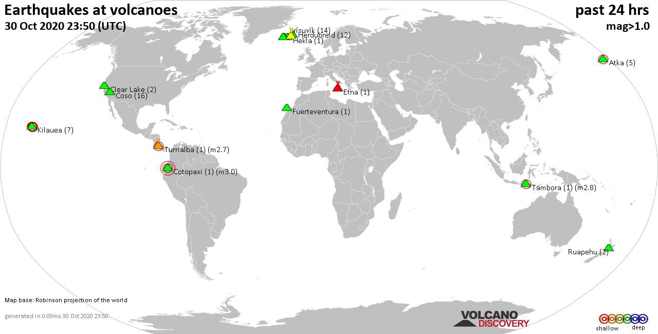
Quakes detected near: Atka (5 quakes between mag 0.6-2.5), Clear Lake (2 quakes between mag 1.4-1.7), Coso (16 quakes between mag 0.2-1.5), Cotopaxi (1 quake mag 3.0), Etna (1 quake mag 1.4), Fuerteventura (1 quake mag 1.8) ... Read all
Show more