Volcano earthquake report for Friday, 9 Apr 2021
Fri, 9 Apr 2021, 23:50 | BY: EARTHQUAKEMONITOR
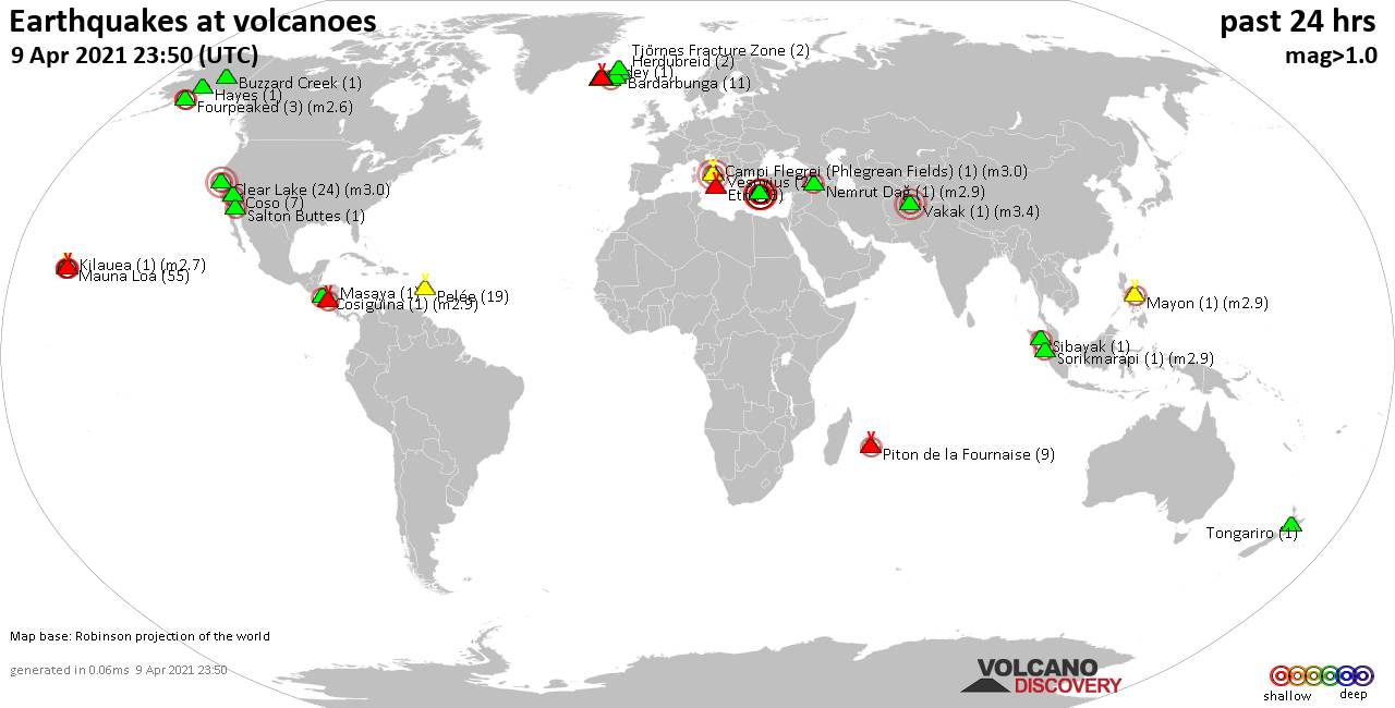
World map showing volcanoes with shallow (less than 20 km) earthquakes within 20 km radius during the past 24 hours on 9 Apr 2021 Number in brackets indicate nr of quakes.
Coso (7 quakes between mag 0.4-2.2), Eldey (1 quake mag 1.5), Etna (3 quakes between mag 1.1-1.5), Fagradalsfjall (23 quakes between mag 0.1-1.6), Fourpeaked (3 quakes between mag 1.6-2.6), Hayes (1 quake mag 1.8), Herdubreid (2 quakes between mag 0.3-1.5), Katla (2 quakes between mag 0.3-2.0), Kilauea (1 quake mag 2.7), Krísuvík (19 quakes between mag 0.3-1.8), Masaya (1 quake mag 2.4), Mauna Loa (55 quakes between mag 0.7-2.4), Mayon (1 quake mag 2.9), Nemrut Dağ (1 quake mag 2.9), Nisyros (18 quakes between mag 1.8-3.7), Pelée (19 quakes between mag 0.1-1.2), Piton de la Fournaise (9 quakes between mag 0.3-2.1), Reykjanes (8 quakes between mag 0.4-1.6), Salton Buttes (1 quake mag 2.3), Sibayak (1 quake mag 2.2), Sorikmarapi (1 quake mag 2.9), Thordarhyrna (1 quake mag 1.0), Tjörnes Fracture Zone (2 quakes between mag 1.0-1.6), Tongariro (1 quake mag 1.5), Vakak (1 quake mag 3.4), Vesuvius (2 quakes between mag 1.0-1.0) (updated 23h50)
Note: Earthquakes within 20 km from and at depths less than 20 km under active volcanoes are reported. The list is not complete because many volcanoes are not monitored and/or seismic data in high resolution is not available publicly.
Volcanoes with recent earthquakes above magnitude 2 or more than 10 quakes are listed below:
Bardarbunga volcano (Iceland): 11 earthquakes up to magnitude 1.5
Possible earthquake swarm: 11 earthquakes occurred near (under) the volcano during 22 hours, the last being recorded quake 1 hour 2 minutes ago. Hypocenter depths ranged between 17.1 and 1.1 km.Earthquake details: (only 5 largest)
1.5 quake 3.3 Km SE of Bárðarbunga, Iceland, 9 April 2021 22:39 GMT (3 km ESE)
1.5 quake 3.4 Km SE of Bárðarbunga, Iceland, 9 April 2021 22:34 GMT (3 km ESE)
1.1 quake 3.2 Km SE of Bárðarbunga, Iceland, 9 April 2021 22:47 GMT (3 km ESE)
1.1 quake 3.3 Km SE of Bárðarbunga, Iceland, 9 April 2021 22:39 GMT (3 km ESE)
0.9 quake 3.3 Km SE of Bárðarbunga, Iceland, 9 April 2021 22:34 GMT (3 km ESE)
All earthquakes at Bardarbunga
Campi Flegrei (Phlegrean Fields) volcano (Italy): magnitude 3.0 earthquake
A magnitude 3.0 earthquake occurred at the volcano 8 hours ago. The quake, which might be volcanic in origin, was located at a depth of 10.0 km depth at 0 km distance N from the volcano.Earthquake details:
Unconfirmed quake: Near nepalasa, Campania, Italy, 9 Apr 5:55 pm (GMT +2) (0 km N)
All earthquakes at Campi Flegrei (Phlegrean Fields)
Clear Lake volcano (California): 24 earthquakes up to magnitude 3.0
Possible earthquake swarm: 24 earthquakes occurred near (under) the volcano during 21 hours, the last being recorded quake 1 hour 3 minutes ago. Hypocenter depths ranged between 10.0 and 1.3 km.Earthquake details: (only 5 largest)
Reported (unconfirmed) earthquake: Near Ukiah, California, USA, 9 April 2021 22:37 GMT (16 km NW)
1.6 quake 2km SW of Cobb, CA, USA, 8 Apr 2021 7:38 pm (GMT -7) (18 km S)
1.5 quake 7km NW of The Geysers, CA, USA, 9 April 2021 16:26 GMT (16 km S)
1.3 quake 9km NW of The Geysers, CA, USA, 8 Apr 2021 10:06 pm (GMT -7) (16 km SSW)
0.9 quake 7km NW of The Geysers, CA, USA, 8 Apr 2021 6:21 pm (GMT -7) (17 km S)
All earthquakes at Clear Lake
Cosigüina volcano (Nicaragua): magnitude 2.9 earthquake
A magnitude 2.9 earthquake occurred at the volcano 20 hours ago. The quake, which might be volcanic in origin, was located at a depth of 5.0 km depth at 17 km distance WSW from the volcano.Earthquake details:
2.9 quake North Pacific Ocean, 70 km northwest of Chinandega, Nicaragua, 8 Apr 2021 9:58 pm (GMT -6) (17 km WSW)
All earthquakes at Cosigüina
Coso volcano (California): 7 earthquakes up to magnitude 2.2
7 earthquakes occurred near (under) the volcano during 12 hours, the last being recorded quake 55 minutes ago. Hypocenter depths ranged between 8.5 and 1.5 km.Earthquake details: (only 5 largest)
2.2 quake 18km ESE of Little Lake, CA, USA, 9 April 2021 22:54 GMT (18 km SSE)
1.7 quake 18km ESE of Little Lake, CA, USA, 9 April 2021 22:45 GMT (18 km SE)
1.2 quake 28km E of Coso Junction, CA, USA, 9 Apr 4:25 am (GMT -7) (17 km ENE)
1.0 quake 20km E of Little Lake, CA, USA, 9 April 2021 17:49 GMT (18 km SE)
0.7 quake 21km E of Little Lake, CA, USA, 9 April 2021 11:19 GMT (15 km ESE)
All earthquakes at Coso
Fagradalsfjall volcano (Reykjanes Peninsula, Iceland): 23 earthquakes up to magnitude 1.6
Possible earthquake swarm: 23 earthquakes occurred near (under) the volcano during 15 hours, the last being recorded quake 8 hours ago. Hypocenter depths ranged between 6.9 and 0.1 km.Earthquake details: (only 5 largest)
1.6 quake 3.0 Km SSW of Keilir, Iceland, 9 April 2021 11:28 GMT (4 km NE)
1.2 quake 3.0 Km SSW of Keilir, Iceland, 9 April 2021 11:27 GMT (4 km NE)
1.2 quake 3.5 Km S of Fagradalsfjall, Iceland, 9 April 2021 02:56 GMT (2 km S)
1.1 quake 3.1 Km S of Fagradalsfjall, Iceland, 9 April 2021 10:57 GMT (2 km S)
1.1 quake 2.9 Km S of Fagradalsfjall, Iceland, 9 April 2021 02:51 GMT (2 km S)
All earthquakes at Fagradalsfjall
Fourpeaked volcano (Alaska Peninsula): 3 earthquakes up to magnitude 2.6
3 earthquakes occurred near (under) the volcano during 19 hours, the last being recorded quake 1 hour 17 minutes ago. Hypocenter depths ranged between 5.6 and 0.0 km.Earthquake details:
2.6 quake 81 Km NNW of Aleneva, Alaska, USA, 8 Apr 2021 7:23 pm (GMT -8) (9 km SE)
2.5 quake 85 Km NNW of Aleneva, Alaska, USA, 8 Apr 2021 8:40 pm (GMT -8) (6 km SSE)
1.6 quake 88 Km NNW of Aleneva, Alaska, USA, 9 April 2021 22:32 GMT (3 km S)
All earthquakes at Fourpeaked
Kilauea volcano (Hawai'i (Big Island)): magnitude 2.7 earthquake
A magnitude 2.7 earthquake occurred at the volcano 5 hours ago. The quake, which might be volcanic in origin, was located at a depth of 3.9 km depth at 7 km distance WNW from the volcano.Earthquake details:
2.7 quake 26 mi southwest of Hilo, Hawaii County, USA, 9 April 2021 19:05 GMT (7 km WNW)
All earthquakes at Kilauea
Krísuvík volcano (Reykjanes Peninsula, Iceland): 19 earthquakes up to magnitude 1.8
Possible earthquake swarm: 19 earthquakes occurred near (under) the volcano during 17 hours, the last being recorded quake 7 hours ago. Hypocenter depths ranged between 6.8 and 0.7 km.Earthquake details: (only 5 largest)
1.8 quake 1.1 Km SW of Keilir, Iceland, 9 April 2021 16:00 GMT (4 km W)
1.6 quake 2.3 Km SSW of Keilir, Iceland, 9 April 2021 02:40 GMT (5 km W)
1.0 quake 7.2 Km NE of Krýsuvík, Iceland, 9 April 2021 12:12 GMT (6 km E)
0.9 quake 2.5 Km SSW of Keilir, Iceland, 9 April 2021 09:19 GMT (5 km WSW)
0.9 quake 2.3 Km SSW of Keilir, Iceland, 9 April 2021 02:36 GMT (5 km W)
All earthquakes at Krísuvík
Masaya volcano (Nicaragua): magnitude 2.4 earthquake
A magnitude 2.4 earthquake occurred at the volcano 6 hours ago. The quake, which might be volcanic in origin, was located at a depth of 5.0 km depth at 2 km distance N from the volcano.Earthquake details:
2.4 quake 7.7 km west of Masaya, Nicaragua, 2021-04-09 12:10:36 (2 km N)
All earthquakes at Masaya
Mauna Loa volcano (Hawai'i (Big Island)): 55 earthquakes up to magnitude 2.4
Possible earthquake swarm: 55 earthquakes occurred near (under) the volcano during 21 hours, the last being recorded quake 3 hours ago. Hypocenter depths ranged between 5.0 and 0.1 km.Earthquake details: (only 5 largest)
2.4 quake 23 Km E of Honaunau-Napoopoo, Hawaii, USA, 9 April 2021 17:58 GMT (4 km W)
2.2 quake 22 Km ENE of Honaunau-Napoopoo, Hawaii, USA, 9 April 2021 13:57 GMT (6 km WNW)
2.1 quake 22 Km ENE of Honaunau-Napoopoo, Hawaii, USA, 9 April 2021 12:47 GMT (7 km WNW)
1.4 quake 23 Km E of Honaunau-Napoopoo, Hawaii, USA, 9 April 2021 17:56 GMT (4 km W)
1.2 quake 22 Km E of Honaunau-Napoopoo, Hawaii, USA, 9 April 2021 13:37 GMT (4 km W)
All earthquakes at Mauna Loa
Mayon volcano (Luzon Island): magnitude 2.9 earthquake
A magnitude 2.9 earthquake occurred at the volcano 8 hours ago. The quake, which might be volcanic in origin, was located at a depth of 10.0 km depth at 14 km distance E from the volcano.Earthquake details:
2.9 quake 14 km northeast of Legazpi, Albay, Bicol, Philippines, 09 April 2021 - 11:43 PM (PST) (14 km E)
All earthquakes at Mayon
Nemrut Dağ volcano (Turkey): magnitude 2.9 earthquake
A magnitude 2.9 earthquake occurred at the volcano 12 hours ago. The quake, which might be volcanic in origin, was located at a depth of 0 km depth at 19 km distance NW from the volcano.Earthquake details:
2.9 quake Muş, 17 km north of Güroymak, Bitlis, Turkey, 9 Apr 3:13 pm (GMT +3) (19 km NW)
All earthquakes at Nemrut Dağ
Nisyros volcano (Greece): 18 earthquakes up to magnitude 3.7
Possible earthquake swarm: 18 earthquakes occurred near (under) the volcano during 22 hours, the last being recorded quake 1 hour 43 minutes ago. Hypocenter depths ranged between 18.0 and 0.0 km.Earthquake details: (only 5 largest)
3.7 quake Aegean Sea, 15 km west of Tilos Island, Dodecanese, South Aegean, Greece, 9 Apr 8:21 pm (GMT +3) (12 km SSE)
3.5 quake Aegean Sea, 17 km west of Tilos Island, Dodecanese, South Aegean, Greece, 9 Apr 8:39 pm (GMT +3) (12 km S)
3.3 quake Aegean Sea, 17 km west of Tilos Island, Dodecanese, South Aegean, Greece, 9 Apr 11:14 pm (GMT +3) (13 km S)
3.2 quake Aegean Sea, 11 km northwest of Tilos Island, Dodecanese, South Aegean, Greece, 10 Apr 1:07 am (GMT +3) (13 km SE)
3.1 quake Aegean Sea, 16 km west of Tilos Island, Dodecanese, South Aegean, Greece, 9 Apr 2021 5:01 am (GMT +3) (12 km S)
All earthquakes at Nisyros
Pelée volcano (Caribbean): 19 earthquakes up to magnitude 1.2
Possible earthquake swarm: 19 earthquakes occurred near (under) the volcano during 14 hours, the last being recorded quake 8 hours ago. Hypocenter depths ranged between 3.1 and 0.3 km.Earthquake details: (only 5 largest)
1.2 quake Near Fort-de-France, Martinique, 9 April 2021 15:20 GMT (1 km SSW)
1.1 quake Near Fort-de-France, Martinique, 9 April 2021 04:18 GMT (1 km SW)
1.0 quake Near Fort-de-France, Martinique, 9 April 2021 04:33 GMT (1 km SSE)
1.0 quake Near Fort-de-France, Martinique, 9 April 2021 06:05 GMT (2 km S)
1.0 quake Near Fort-de-France, Martinique, 9 April 2021 07:29 GMT (4 km SSW)
All earthquakes at Pelée
Piton de la Fournaise volcano (Indian Ocean): 9 earthquakes up to magnitude 2.1
9 earthquakes occurred near (under) the volcano during 11 hours, the last being recorded quake 12 hours ago. Hypocenter depths ranged between 0.7 and 0.2 km.Earthquake details: (only 5 largest)
2.1 quake 21 km east of Le Tampon, Réunion, 9 Apr 2:25 pm (GMT +4) (0 km ESE)
1.4 quake Near Saint-Pierre, Réunion, 9 Apr 3:42 pm (GMT +4) (1 km E)
1.1 quake Near Saint-Pierre, Réunion, 9 Apr 2021 4:44 am (GMT +4) (1 km ENE)
0.9 quake Near Saint-Pierre, Réunion, 9 Apr 2021 11:41 am (GMT +4) (0 km E)
0.9 quake Near Saint-Pierre, Réunion, 9 Apr 2021 10:56 am (GMT +4) (0 km NNW)
All earthquakes at Piton de la Fournaise
Salton Buttes volcano (California): magnitude 2.3 earthquake
A magnitude 2.3 earthquake occurred at the volcano 3 hours ago. The quake, which might be volcanic in origin, was located at a depth of 8.9 km depth at 9 km distance S from the volcano.Earthquake details:
2.3 quake 9km N of Westmorland, CA, USA, 9 April 2021 20:29 GMT (9 km S)
All earthquakes at Salton Buttes
Sibayak volcano (Sumatra): magnitude 2.2 earthquake
A magnitude 2.2 earthquake occurred at the volcano 5 hours ago. The quake, which might be volcanic in origin, was located at a depth of 10.0 km depth at 19 km distance SSE from the volcano.Earthquake details:
2.2 quake 8.9 km east of Kabanjahe, Sumatera Utara, Indonesia, 9 April 2021 19:03 GMT (19 km SSE)
All earthquakes at Sibayak
Sorikmarapi volcano (Sumatra): magnitude 2.9 earthquake
A magnitude 2.9 earthquake occurred at the volcano 16 hours ago. The quake, which might be volcanic in origin, was located at a depth of 10.0 km depth at 19 km distance N from the volcano.Earthquake details:
2.9 quake 66 km southeast of Padangsidempuan, Sumatera Utara, Indonesia, 9 Apr 2021 3:06 pm (GMT +7) (19 km N)
All earthquakes at Sorikmarapi
Vakak volcano (Afghanistan ): magnitude 3.4 earthquake
A magnitude 3.4 earthquake occurred at the volcano 18 hours ago. The quake, which might be volcanic in origin, was located at a depth of 10.0 km depth at 13 km distance SW from the volcano.Earthquake details:
3.4 quake Markazi Bihsud, Wardak, 84 km northwest of Ghazni, Ghaznī, Ghazni, Afghanistan, 9 Apr 2021 9:59 am (GMT +4:30) (13 km SW)
All earthquakes at Vakak
Previous news
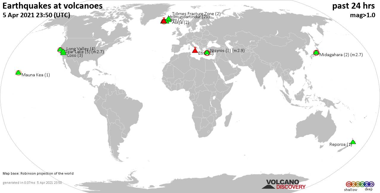
Thu, 8 Apr 2021, 23:50
Volcano earthquake report for Thursday, 8 Apr 2021
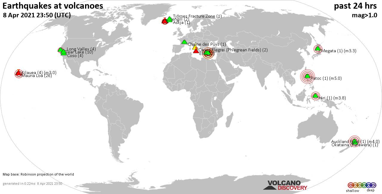
Quakes detected near: Askja (1 quake mag 1.0), Auckland Field (1 quake mag 4.0), Brennisteinsfjöll (3 quakes between mag 0.5-1.1), Campi Flegrei (Phlegrean Fields) (2 quakes between mag 0.4-1.0), Chaîne des Puys (1 quake mag 1.1), Clear Lake (10 quakes between mag 0.4-2.3) ... Read all
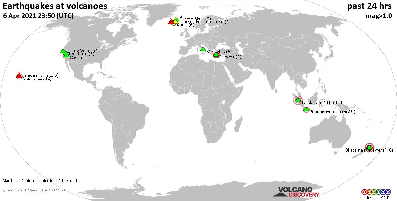
Wed, 7 Apr 2021, 23:50
Volcano earthquake report for Wednesday, 7 Apr 2021
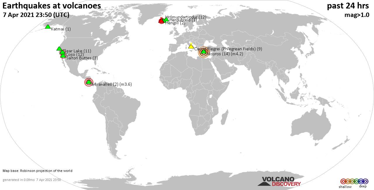
Quakes detected near: Brennisteinsfjöll (3 quakes between mag 0.1-1.4), Campi Flegrei (Phlegrean Fields) (9 quakes between mag 0.2-1.9), Clear Lake (11 quakes between mag 0.3-1.6), Coso (12 quakes between mag 0.3-2.3), Fagradalsfjall (15 quakes between mag 0.4-2.8), Hengill (2 quakes between mag 0.6-2.0) ... Read all
Show more