Volcano earthquake report for Saturday, 8 May 2021
Sat, 8 May 2021, 23:50 | BY: EARTHQUAKEMONITOR

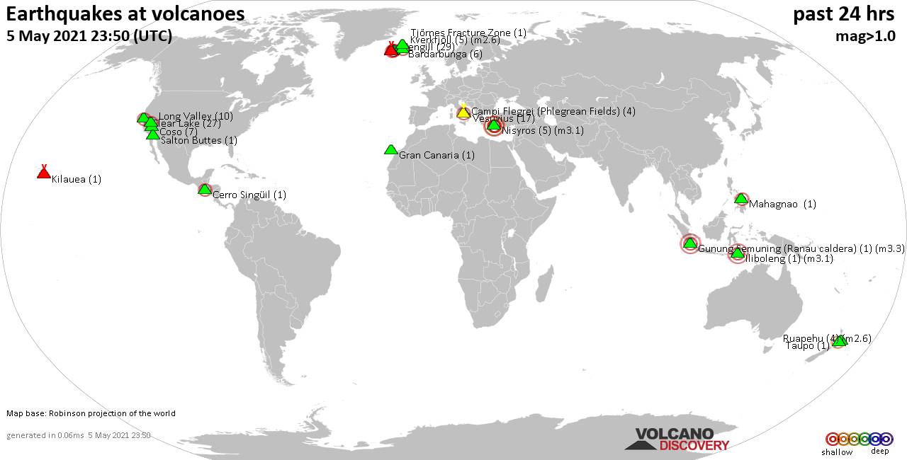
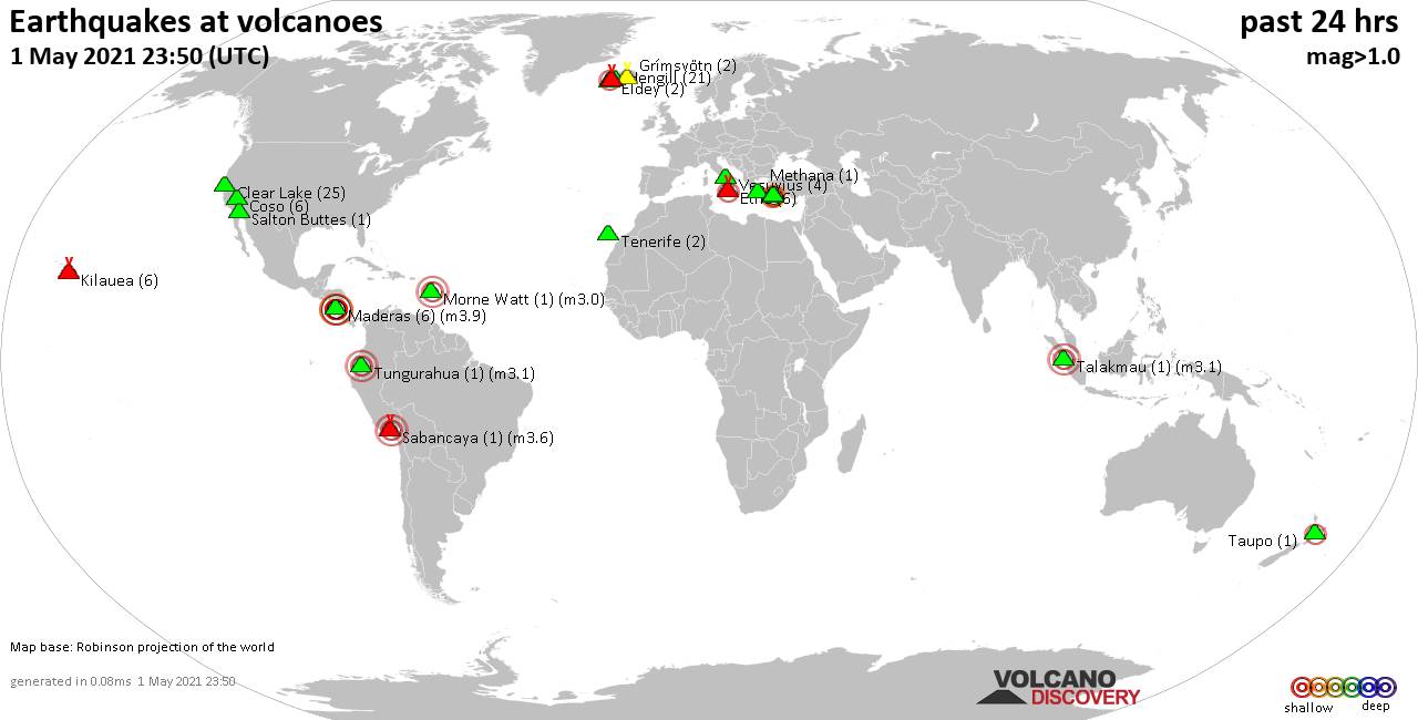
World map showing volcanoes with shallow (less than 20 km) earthquakes within 20 km radius during the past 24 hours on 8 May 2021 Number in brackets indicate nr of quakes.
Etna (18 quakes between mag 1.0-3.1), Hrómundartindur (1 quake mag 1.4), Katla (3 quakes between mag 0.5-2.0), Krísuvík (10 quakes between mag 0.1-2.6), Maroa (1 quake mag 1.2), Maunaloa (1 quake mag 1.7), Miravalles (1 quake mag 3.0), Nisyros (4 quakes between mag 1.9-3.9), Porak (1 quake mag 2.5), Prestahnukur (1 quake mag 2.1), Reykjanes (5 quakes between mag 0.7-1.3), Sibualbuali (1 quake mag 3.0), Takawangha (1 quake mag 1.3), Tenerife (1 quake mag 1.0), Vesuvius (10 quakes between mag 0.1-1.5), Yake-dake (1 quake mag 2.5) (updated 23h50)
Note: Earthquakes within 20 km from and at depths less than 20 km under active volcanoes are reported. The list is not complete because many volcanoes are not monitored and/or seismic data in high resolution is not available publicly.
Volcanoes with recent earthquakes above magnitude 2 or more than 10 quakes are listed below:
Auckland Field volcano (North Island): magnitude 3.0 earthquake
A magnitude 3.0 earthquake occurred at the volcano 14 hours ago. The quake, which might be volcanic in origin, was located at a depth of 10.0 km depth at 3 km distance ENE from the volcano.Earthquake details:
Unconfirmed quake reported: 13 km east of Auckland, New Zealand, 8 May 2021 10:10 GMT (3 km ENE)
All earthquakes at Auckland Field
Bardarbunga volcano (Iceland): 12 earthquakes up to magnitude 1.3
Possible earthquake swarm: 12 earthquakes occurred near (under) the volcano during 7 hours, the last being recorded quake 4 hours ago. Hypocenter depths ranged between 17.8 and 1.1 km.Earthquake details: (only 5 largest)
1.3 quake 18.3 Km ESE of Bárðarbunga, Iceland, 8 May 2021 19:13 GMT (18 km ESE)
1.2 quake 16.6 Km ESE of Bárðarbunga, Iceland, 8 May 2021 19:15 GMT (16 km ESE)
1.2 quake 16.6 Km ESE of Bárðarbunga, Iceland, 8 May 2021 19:15 GMT (16 km ESE)
1.1 quake 17.2 Km ESE of Bárðarbunga, Iceland, 8 May 2021 19:17 GMT (17 km E)
1.0 quake 16.8 Km E of Bárðarbunga, Iceland, 8 May 2021 19:20 GMT (17 km E)
All earthquakes at Bardarbunga
Brennisteinsfjöll volcano (Reykjanes Peninsula, Iceland): 3 earthquakes up to magnitude 2.7
3 earthquakes occurred near (under) the volcano during 14 hours, the last being recorded quake 10 hours ago. Hypocenter depths ranged between 4.2 and 2.8 km.Earthquake details:
2.7 quake 6.9 Km NNW of Bláfjallaskáli, Iceland, 8 May 2021 04:47 GMT (15 km NNE)
1.6 quake 9.1 Km WSW of Raufarhólshellir, Iceland, 8 May 2021 00:41 GMT (14 km E)
0.9 quake 6.9 Km NNW of Bláfjallaskáli, Iceland, 8 May 2021 14:12 GMT (15 km NNE)
All earthquakes at Brennisteinsfjöll
Cerro Nicholson volcano (Peru): magnitude 3.7 earthquake
A magnitude 3.7 earthquake occurred at the volcano 21 hours ago. The quake, which might be volcanic in origin, was located at a depth of 18.0 km depth at 13 km distance SSE from the volcano.Earthquake details:
3.7 quake 18 km west of Arequipa, Peru, 8 May 2021 02:55 GMT (13 km SSE)
All earthquakes at Cerro Nicholson
Clear Lake volcano (California): 20 earthquakes up to magnitude 1.5
Possible earthquake swarm: 20 earthquakes occurred near (under) the volcano during 21 hours, the last being recorded quake 3 hours ago. Hypocenter depths ranged between 15.4 and 0.6 km.Earthquake details: (only 5 largest)
1.5 quake 4km W of Cobb, CA, USA, 8 May 2021 11:10 GMT (16 km S)
1.4 quake 10km WNW of The Geysers, CA, USA, 8 May 2021 02:58 GMT (18 km SSW)
1.2 quake 6km W of Cobb, CA, USA, 8 May 2021 08:54 GMT (16 km S)
1.1 quake 7km NW of The Geysers, CA, USA, 8 May 2021 01:07 GMT (18 km SSW)
1.0 quake 4km NW of The Geysers, CA, USA, 8 May 2021 18:38 GMT (19 km S)
All earthquakes at Clear Lake
Etna volcano (Italy): 18 earthquakes up to magnitude 3.1
Possible earthquake swarm: 18 earthquakes occurred near (under) the volcano during 21 hours, the last being recorded quake 2 hours ago. Hypocenter depths ranged between 11.4 and 0.0 km.Earthquake details: (only 5 largest)
3.1 quake 8.1 km northwest of Giarre, Catania, Sicily, Italy, 8 May 2021 18:09 GMT (9 km E)
2.2 quake 9.3 km northwest of Giarre, Catania, Sicily, Italy, 8 May 2021 18:20 GMT (9 km ENE)
2.2 quake 8.5 km northwest of Giarre, Catania, Sicily, Italy, 8 May 2021 18:10 GMT (10 km ENE)
2.1 quake 8.4 km northwest of Giarre, Catania, Sicily, Italy, 8 May 2021 21:40 GMT (10 km E)
1.8 quake 9.2 km west of Giarre, Catania, Sicily, Italy, 8 May 2021 18:07 GMT (8 km E)
All earthquakes at Etna
Krísuvík volcano (Reykjanes Peninsula, Iceland): 10 earthquakes up to magnitude 2.6
10 earthquakes occurred near (under) the volcano during 15 hours, the last being recorded quake 4 hours ago. Hypocenter depths ranged between 5.6 and 1.7 km.Earthquake details: (only 5 largest)
2.6 quake Near Reykjavik, Capital Region, Iceland, 8 May 2021 20:02 GMT (4 km E)
0.9 quake 5.2 Km NNE of Krýsuvík, Iceland, 8 May 2021 13:00 GMT (3 km E)
0.9 quake 2.1 Km SW of Keilir, Iceland, 8 May 2021 07:52 GMT (5 km W)
0.8 quake 1.9 Km SSW of Keilir, Iceland, 8 May 2021 05:27 GMT (5 km W)
0.4 quake 2.5 Km SW of Keilir, Iceland, 8 May 2021 13:34 GMT (5 km W)
All earthquakes at Krísuvík
Miravalles volcano (Costa Rica): magnitude 3.0 earthquake
A magnitude 3.0 earthquake occurred at the volcano 6 hours ago. The quake, which might be volcanic in origin, was located at a depth of 5.0 km depth at 4 km distance SW from the volcano.Earthquake details:
3.0 quake Bagaces, 30 km east of Liberia, Provincia de Guanacaste, Costa Rica, 08 de mayo del 2021 11:40 am (4 km SW)
All earthquakes at Miravalles
Nisyros volcano (Greece): 4 earthquakes up to magnitude 3.9
4 earthquakes occurred near (under) the volcano during 11 hours, the last being recorded quake 12 hours ago. Hypocenter depths ranged between 17.1 and 9.5 km.Earthquake details:
3.9 quake Aegean Sea, 47 km south of Kos Town, Dodecanese, South Aegean, Greece, 8 May 2:41 pm (GMT +3) (12 km S)
2.1 quake Aegean Sea, 46 km south of Kos Town, Dodecanese, South Aegean, Greece, 8 May 2021 11:46 GMT (9 km S)
2.0 quake Aegean Sea, 54 km south of Kos Town, Dodecanese, South Aegean, Greece, 8 May 2021 06:25 GMT (16 km SSW)
1.9 quake Aegean Sea, 55 km south of Kos Town, Dodecanese, South Aegean, Greece, 8 May 2021 00:34 GMT (7 km SSW)
All earthquakes at Nisyros
Porak volcano (Armenia): magnitude 2.5 earthquake
A magnitude 2.5 earthquake occurred at the volcano 14 hours ago. The quake, which might be volcanic in origin, was located at a depth of 9.0 km depth at 17 km distance E from the volcano.Earthquake details:
2.5 quake 13 km southwest of Kǝlbǝcǝr, Kalbajar, Azerbaijan, 8 May 2021 10:01 GMT (17 km E)
All earthquakes at Porak
Prestahnukur volcano (Iceland): magnitude 2.1 earthquake
A magnitude 2.1 earthquake occurred at the volcano 10 hours ago. The quake, which might be volcanic in origin, was located at a depth of 6.2 km depth at 2 km distance NE from the volcano.Earthquake details:
2.1 quake 18.1 Km ESE of Húsafell, Iceland, 8 May 2021 14:03 GMT (2 km NE)
All earthquakes at Prestahnukur
Sibualbuali volcano (Sumatra): magnitude 3.0 earthquake
A magnitude 3.0 earthquake occurred at the volcano 18 hours ago. The quake, which might be volcanic in origin, was located at a depth of 10.0 km depth at 18 km distance SSE from the volcano.Earthquake details:
3.0 quake 8.9 km northeast of Padangsidempuan, North Sumatra, Indonesia, 8 May 2021 06:18 GMT (18 km SSE)
All earthquakes at Sibualbuali
Yake-dake volcano (Honshu): magnitude 2.5 earthquake
A magnitude 2.5 earthquake occurred at the volcano 4 hours ago. The quake, which might be volcanic in origin, was located at a depth of 5.2 km depth at 5 km distance ENE from the volcano.Earthquake details:
2.5 quake Takayama Shi, Gifu, 24 km southwest of Hotaka, Azumino-Shi, Nagano, Japan, May 09, 2021 04:25:51.57 (5 km ENE)
All earthquakes at Yake-dake
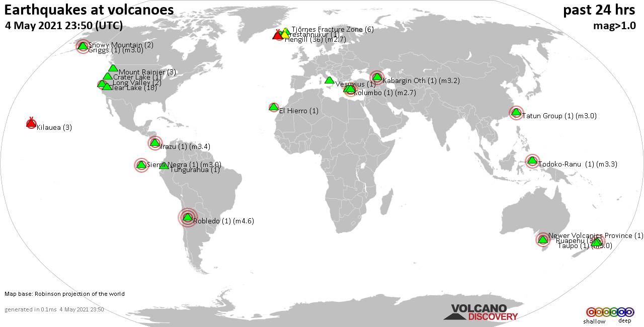
Previous news
Fri, 7 May 2021, 23:50
Volcano earthquake report for Friday, 7 May 2021
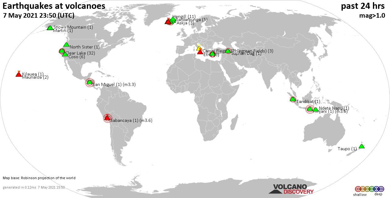
Quakes detected near: Askja (3 quakes between mag 0.1-1.0), Bardarbunga (5 quakes between mag 0.1-1.0), Brennisteinsfjöll (4 quakes between mag 0.3-2.7), Campi Flegrei (Phlegrean Fields) (3 quakes between mag 0.2-1.0), Clear Lake (32 quakes between mag 0.4-2.0), Coso (6 quakes between mag 0.3-1.3) ... Read all
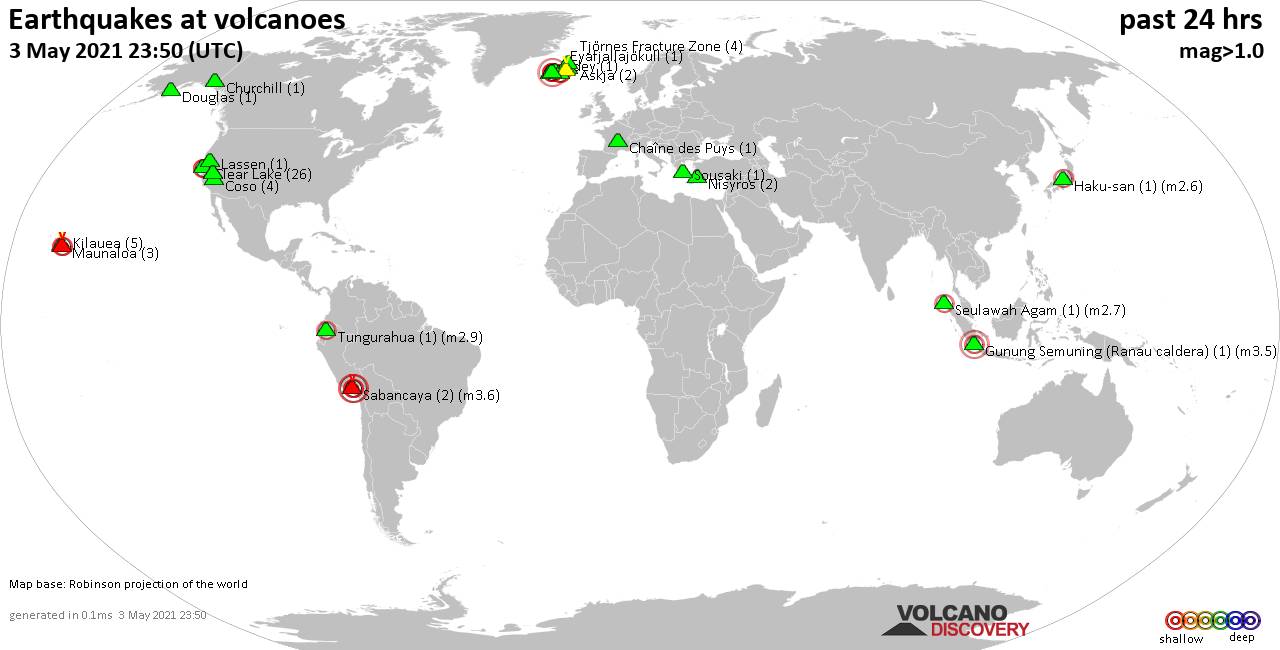
Thu, 6 May 2021, 23:50
Volcano earthquake report for Thursday, 6 May 2021
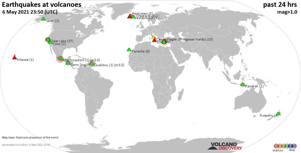
Quakes detected near: Campi Flegrei (Phlegrean Fields) (10 quakes between mag 0.2-1.0), Cerro Singüil (1 quake mag 2.4), Chichinautzin (1 quake mag 3.0), Clear Lake (37 quakes between mag 0.4-2.5), Coso (2 quakes between mag 0.5-1.1), Etna (44 quakes between mag 1.0-1.9) ... Read all
Show more