Volcano earthquake report for Monday, 27 Sep 2021
Mon, 27 Sep 2021, 23:50 | BY: EARTHQUAKEMONITOR
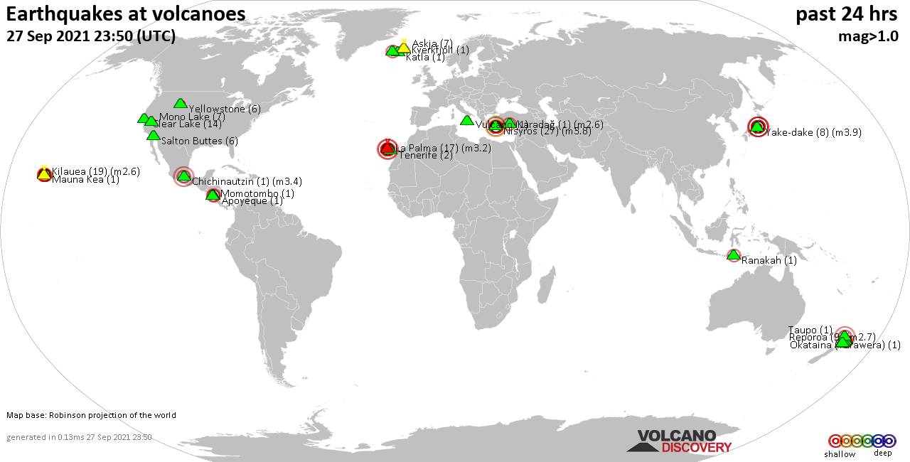
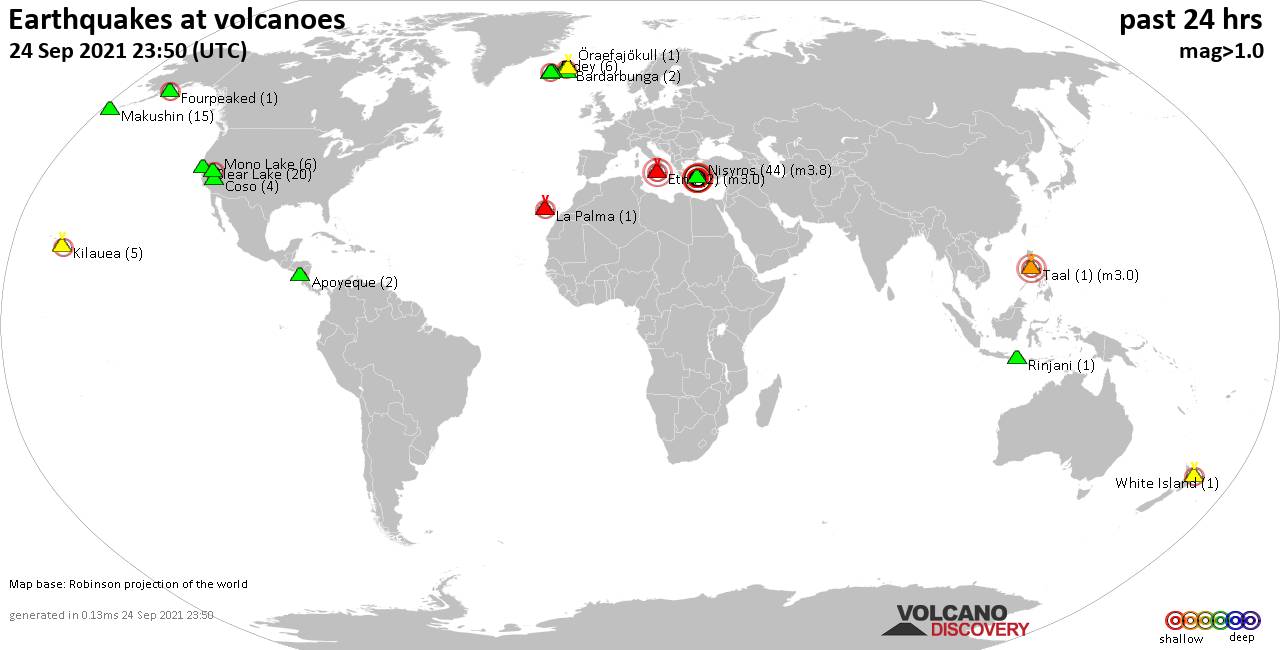
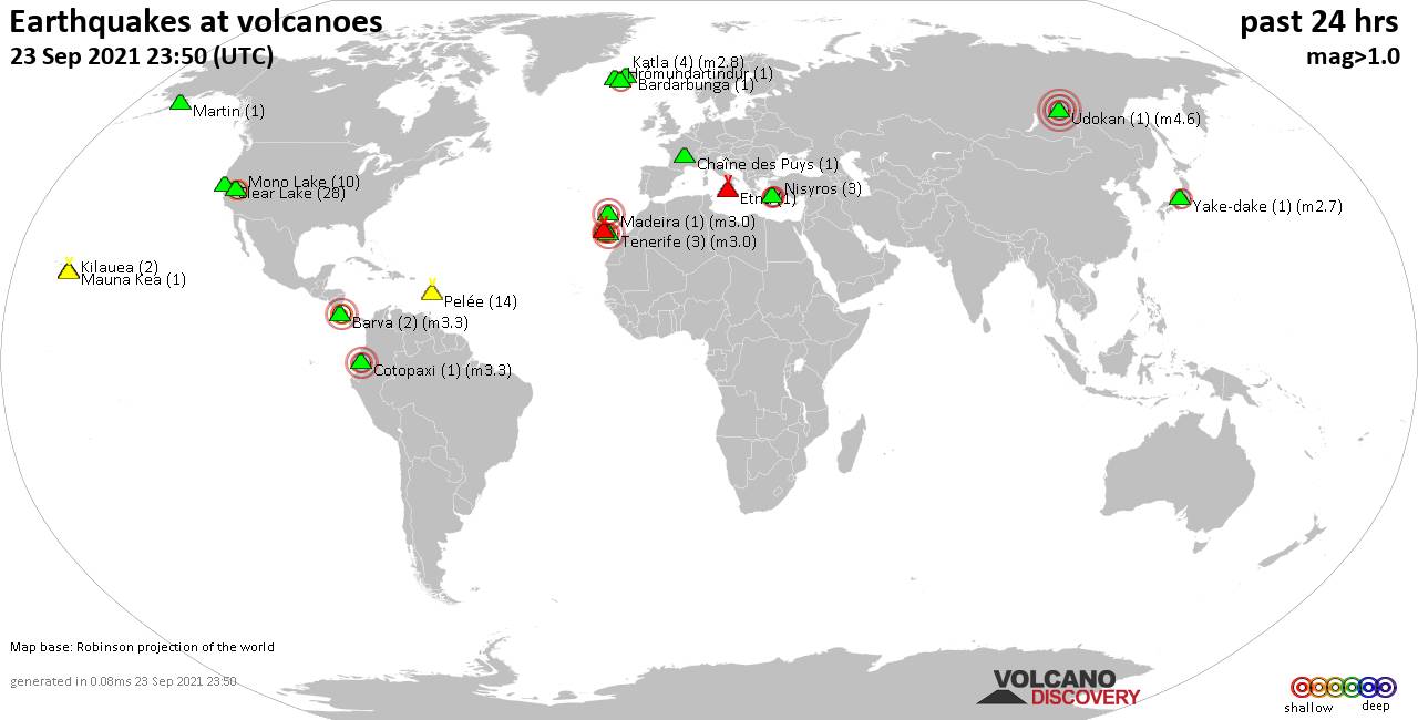
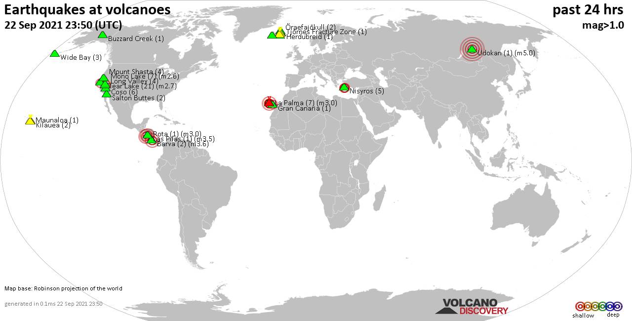
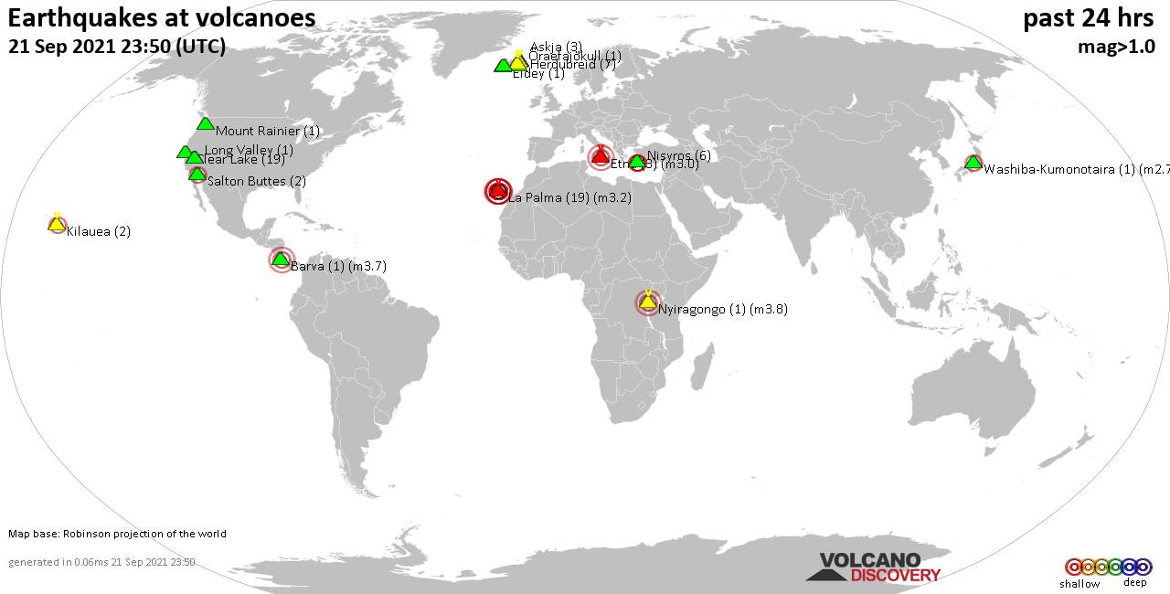
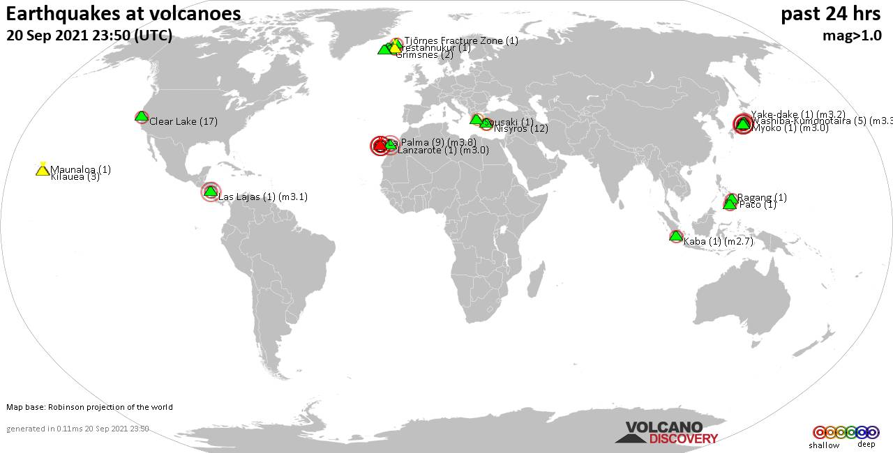
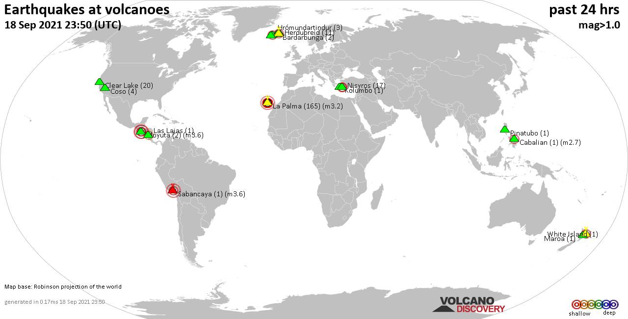
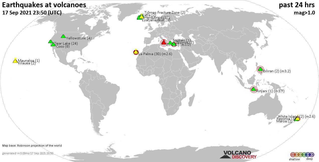
World map showing volcanoes with shallow (less than 20 km) earthquakes within 20 km radius during the past 24 hours on 27 Sep 2021 Number in brackets indicate nr of quakes.
Katla (1 quake mag 1.2), Kilauea (19 quakes between mag 0.6-2.6), Krísuvík (11 quakes between mag 0.6-2.0), Kverkfjöll (1 quake mag 1.0), La Palma (17 quakes between mag 2.0-3.2), Mauna Kea (1 quake mag 2.4), Momotombo (1 quake mag 2.4), Mono Lake (7 quakes between mag 0.7-1.8), Nisyros (27 quakes between mag 1.4-3.8), Okataina (Tarawera) (1 quake mag 1.6), Ranakah (1 quake mag 2.1), Reporoa (9 quakes between mag 1.2-2.7), Ruapehu (1 quake mag 1.2), Salton Buttes (6 quakes between mag 1.1-1.4), Taupo (1 quake mag 1.3), Tenerife (2 quakes between mag 1.1-1.1), Tongariro (7 quakes between mag 0.7-1.1), Vulcano (1 quake mag 1.9), Yake-dake (8 quakes between mag 2.6-3.9), Yellowstone (6 quakes between mag 0.3-1.6) (updated 23h50)
Note: Earthquakes within 20 km from and at depths less than 20 km under active volcanoes are reported. The list is not complete because many volcanoes are not monitored and/or seismic data in high resolution is not available publicly.
Volcanoes with recent earthquakes above magnitude 2 or more than 10 quakes are listed below:
Apoyeque volcano (Nicaragua): magnitude 2.2 earthquake
A magnitude 2.2 earthquake occurred at the volcano 4 hours ago. The quake, which might be volcanic in origin, was located at a depth of 7.0 km depth at 6 km distance SW from the volcano.Earthquake details:
2.2 quake 16 km northwest of Managua, Nicaragua, Sep 27, 2021 1:42 pm (GMT -6) (6 km SW)
All earthquakes at Apoyeque
Auckland Field volcano (North Island): magnitude 3.0 earthquake
A magnitude 3.0 earthquake occurred at the volcano 6 hours ago. The quake, which might be volcanic in origin, was located at a depth of 10.0 km depth at 12 km distance WNW from the volcano.Earthquake details:
Reported seismic-like event (likely no quake): 1.4 km west of Auckland, New Zealand, Sep 28, 2021 6:22 am (GMT +13) (12 km WNW)
All earthquakes at Auckland Field
Chichinautzin volcano (Western & Central Mexico): magnitude 3.4 earthquake
A magnitude 3.4 earthquake occurred at the volcano 18 hours ago. The quake, which might be volcanic in origin, was located at a depth of 2.0 km depth at 18 km distance SSW from the volcano.Earthquake details:
3.4 quake 2.7 km northeast of Cuernavaca, Morelos, Mexico, Sep 27, 2021 12:52 am (GMT -5) (18 km SSW)
All earthquakes at Chichinautzin
Clear Lake volcano (California): 14 earthquakes up to magnitude 1.2
Possible earthquake swarm: 14 earthquakes occurred near (under) the volcano during 23 hours, the last being recorded quake 26 minutes ago. Hypocenter depths ranged between 3.0 and 1.2 km.Earthquake details: (only 5 largest)
1.2 quake 5km NW of The Geysers, CA, Sep 27, 2021 10:25 am (GMT -7) (18 km S)
1.2 quake 3km W of Cobb, CA, Sep 27, 2021 3:48 pm (GMT -7) (17 km S)
1.1 quake 10km NW of The Geysers, CA, Sep 27, 2021 3:10 am (GMT -7) (16 km SSW)
1.1 quake 8km W of Cobb, CA, Sep 26, 2021 11:20 pm (GMT -7) (15 km SSW)
1.0 quake 10km NW of The Geysers, CA, Sep 27, 2021 4:24 pm (GMT -7) (16 km SSW)
All earthquakes at Clear Lake
Karadağ volcano (Turkey): magnitude 2.6 earthquake
A magnitude 2.6 earthquake occurred at the volcano 11 hours ago. The quake, which might be volcanic in origin, was located at a depth of 7.2 km depth at 13 km distance WNW from the volcano.Earthquake details:
2.6 quake Karaman, 24 km southeast of Çumra, Konya, Turkey, Sep 27, 2021 3:56 pm (GMT +3) (13 km WNW)
All earthquakes at Karadağ
Kilauea volcano (Hawai'i (Big Island)): 19 earthquakes up to magnitude 2.6
Possible earthquake swarm: 19 earthquakes occurred near (under) the volcano during 21 hours, the last being recorded quake 1 hour 51 minutes ago. Hypocenter depths ranged between 4.4 and 0.0 km.Earthquake details: (only 5 largest)
2.6 quake 26 mi southwest of Hilo, Hawaii County, USA, Sep 27, 2021 8:18 am (GMT -10) (0 km ESE)
2.3 quake 6 Km S of Volcano, Hawaii, Sep 26, 2021 2:39 pm (GMT -10) (6 km ESE)
2.3 quake 5 Km SW of Volcano, Hawaii, Sep 27, 2021 10:32 am (GMT -10) (1 km NE)
2.2 quake 5 Km SW of Volcano, Hawaii, Sep 26, 2021 10:12 pm (GMT -10) (1 km NE)
2.1 quake 6 Km S of Volcano, Hawaii, Sep 26, 2021 9:02 pm (GMT -10) (6 km ESE)
All earthquakes at Kilauea
Krísuvík volcano (Reykjanes Peninsula, Iceland): 11 earthquakes up to magnitude 2.0
Possible earthquake swarm: 11 earthquakes occurred near (under) the volcano during 15 hours, the last being recorded quake 54 minutes ago. Hypocenter depths ranged between 7.6 and 5.0 km.Earthquake details: (only 5 largest)
2.0 quake Iceland: 0.9 Km SW of Keilir Sep 27, 2021 10:55 pm (GMT +0) (4 km W)
1.5 quake Iceland: 1.3 Km SW of Keilir Sep 27, 2021 6:30 pm (GMT +0) (4 km W)
1.5 quake Iceland: 1.6 Km SSW of Keilir Sep 27, 2021 2:54 pm (GMT +0) (4 km W)
1.4 quake Iceland: 1.6 Km SSW of Keilir Sep 27, 2021 1:42 pm (GMT +0) (4 km W)
1.2 quake Iceland: 1.6 Km S of Keilir Sep 27, 2021 10:41 am (GMT +0) (4 km W)
All earthquakes at Krísuvík
La Palma volcano (Canary Islands): 17 earthquakes up to magnitude 3.2
Possible earthquake swarm: 17 earthquakes occurred near (under) the volcano during 5 hours, the last being recorded quake 17 hours ago. Hypocenter depths ranged between 13.0 and 9.0 km.Earthquake details: (only 5 largest)
3.2 quake La Palma Island, 10.9 km south of Los Llanos de Aridane, Spain, Sep 27, 2021 7:05 am (GMT +1) (4 km WSW)
Reported seismic-like event (likely no quake): 7.2 km east of Los Llanos de Aridane, Tenerife, Canary Islands, Spain, Sep 27, 2021 2:56 am (GMT +1) (9 km N)
2.7 quake La Palma Island, 14 km southeast of Los Llanos de Aridane, Spain, Sep 27, 2021 6:09 am (GMT +1) (2 km S)
2.6 quake La Palma Island, 14 km southeast of Los Llanos de Aridane, Spain, Sep 27, 2021 5:17 am (GMT +1) (3 km SSE)
2.5 quake 12 km south of Los Llanos de Aridane, Tenerife, Canary Islands, Spain, Sep 27, 2021 5:09 am (GMT +1) (6 km WSW)
All earthquakes at La Palma
Mauna Kea volcano (Hawai'i (Big Island)): magnitude 2.4 earthquake
A magnitude 2.4 earthquake occurred at the volcano 20 hours ago. The quake, which might be volcanic in origin, was located at a depth of 17.5 km depth at 16 km distance N from the volcano.Earthquake details:
2.4 quake 13 Km SSW of Honoka'a, Hawaii, Sep 26, 2021 5:46 pm (GMT -10) (16 km N)
All earthquakes at Mauna Kea
Momotombo volcano (Nicaragua): magnitude 2.4 earthquake
A magnitude 2.4 earthquake occurred at the volcano 4 hours ago. The quake, which might be volcanic in origin, was located at a depth of 5.0 km depth at 18 km distance ENE from the volcano.Earthquake details:
2.4 quake Departamento de Leon, 43 km north of Managua, Nicaragua, Sep 27, 2021 1:42 pm (GMT -6) (18 km ENE)
All earthquakes at Momotombo
Nisyros volcano (Greece): 27 earthquakes up to magnitude 3.8
Possible earthquake swarm: 27 earthquakes occurred near (under) the volcano during 22 hours, the last being recorded quake 38 minutes ago. Hypocenter depths ranged between 18.1 and 2.3 km.Earthquake details: (only 5 largest)
3.8 quake Aegean Sea, 38 km south of Kos, Dodecanese, South Aegean, Greece, Sep 27, 2021 6:04 pm (GMT +3) (14 km ESE)
3.7 quake Aegean Sea, 48 km south of Kos, Dodecanese, South Aegean, Greece, Sep 28, 2021 2:11 am (GMT +3) (11 km S)
2.8 quake Aegean Sea, 43 km south of Kos, Dodecanese, South Aegean, Greece, Sep 27, 2021 6:15 am (GMT +3) (13 km SSE)
2.7 quake Aegean Sea, 48 km south of Kos, Dodecanese, South Aegean, Greece, Sep 27, 2021 8:27 am (GMT +3) (12 km S)
2.4 quake Aegean Sea, 47 km south of Kos, Dodecanese, South Aegean, Greece, Sep 27, 2021 2:22 pm (GMT +3) (14 km SE)
All earthquakes at Nisyros
Ranakah volcano (Flores): magnitude 2.1 earthquake
A magnitude 2.1 earthquake occurred at the volcano 20 hours ago. The quake, which might be volcanic in origin, was located at a depth of 10.0 km depth at 15 km distance N from the volcano.Earthquake details:
2.1 quake 14 km north of Ruteng, Kabupaten Manggarai, East Nusa Tenggara, Indonesia, Sep 27, 2021 11:37 am (GMT +8) (15 km N)
All earthquakes at Ranakah
Reporoa volcano (New Zealand): 9 earthquakes up to magnitude 2.7
9 earthquakes occurred near (under) the volcano during 11 hours, the last being recorded quake 12 hours ago. Hypocenter depths ranged between 5.0 and 3.8 km.Earthquake details: (only 5 largest)
2.7 quake 40 km south of Rotorua, Bay of Plenty, New Zealand, Sep 27, 2021 9:26 pm (GMT +13) (8 km SSW)
2.0 quake Rotorua District, Bay of Plenty, 27 km northeast of Taupo, Waikato, New Zealand, Sep 27, 2021 2:00 pm (GMT +13) (10 km SW)
2.0 quake 38 km south of Rotorua, Bay of Plenty, New Zealand, Sep 27, 2021 2:01 pm (GMT +13) (11 km SW)
1.9 quake 37 km south of Rotorua, Bay of Plenty, New Zealand, Sep 27, 2021 2:03 pm (GMT +13) (8 km SW)
1.7 quake Rotorua District, Bay of Plenty, 28 km northeast of Taupo, Waikato, New Zealand, Sep 28, 2021 1:01 am (GMT +13) (9 km SSW)
All earthquakes at Reporoa
Yake-dake volcano (Honshu): 8 earthquakes up to magnitude 3.9
8 earthquakes occurred near (under) the volcano during 10 hours, the last being recorded quake 7 hours ago. Hypocenter depths ranged between 4.5 and 3.1 km.Earthquake details: (only 5 largest)
3.9 quake Takayama Shi, Gifu, 30 km west of Matsumoto, Nagano, Japan, Sep 27, 2021 7:54 pm (GMT +9) (6 km NE)
3.8 quake Takayama Shi, Gifu, 30 km west of Matsumoto, Nagano, Japan, Sep 27, 2021 8:25 pm (GMT +9) (6 km NE)
3.2 quake Takayama Shi, Gifu, 31 km west of Matsumoto, Nagano, Japan, Sep 27, 2021 4:49 pm (GMT +9) (6 km NE)
2.9 quake Takayama Shi, Gifu, 24 km west of Hotaka, Azumino-Shi, Nagano, Japan, Sep 27, 2021 6:05 pm (GMT +9) (6 km NE)
2.8 quake Takayama Shi, Gifu, 24 km west of Hotaka, Azumino-Shi, Nagano, Japan, Sep 28, 2021 2:01 am (GMT +9) (6 km NE)
All earthquakes at Yake-dake
Previous news
Sun, 26 Sep 2021, 23:50
Volcano earthquake report for Sunday, 26 Sep 2021

Quakes detected near: Askja (8 quakes between mag 0.4-1.0), Bardarbunga (2 quakes between mag 1.2-1.8), Clear Lake (17 quakes between mag 0.3-1.6), Coso (9 quakes between mag 0.5-1.2), Eldey (1 quake mag 1.3), Etna (4 quakes between mag 1.1-3.0) ... Read all
Sat, 25 Sep 2021, 23:50
Volcano earthquake report for Saturday, 25 Sep 2021
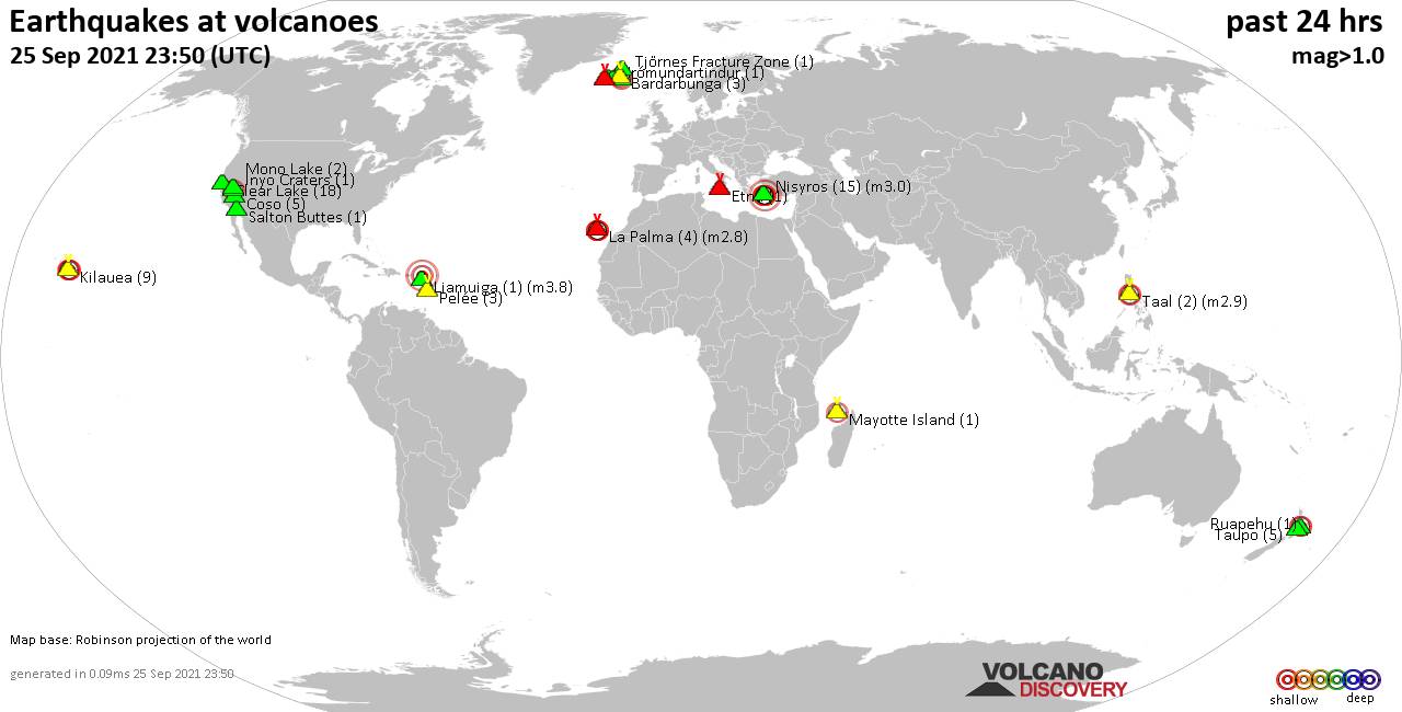
Quakes detected near: Bardarbunga (3 quakes between mag 0.7-1.8), Clear Lake (18 quakes between mag 0.4-1.5), Coso (5 quakes between mag 0.9-1.1), Etna (1 quake mag 1.5), Fagradalsfjall (1 quake mag 1.0), Grímsvötn (3 quakes between mag 1.2-2.1) ... Read all
Show more