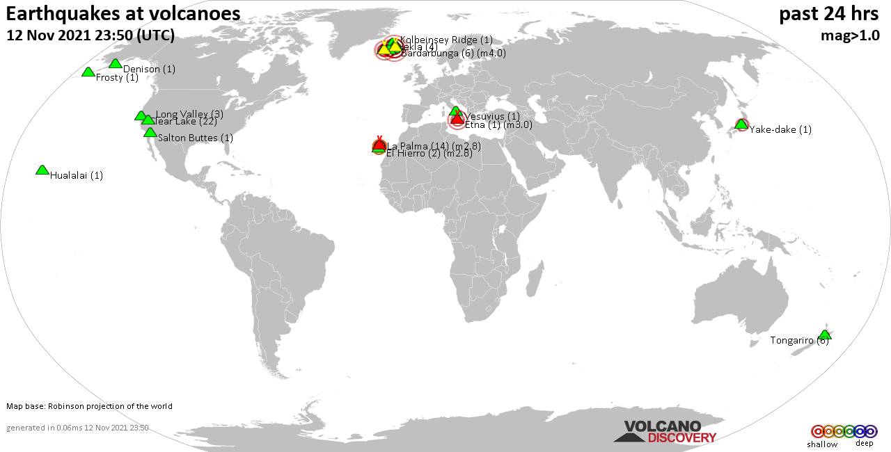
Volcano earthquake report for Wednesday, 17 Nov 2021
Wed, 17 Nov 2021, 23:50 | BY: EARTHQUAKEMONITOR

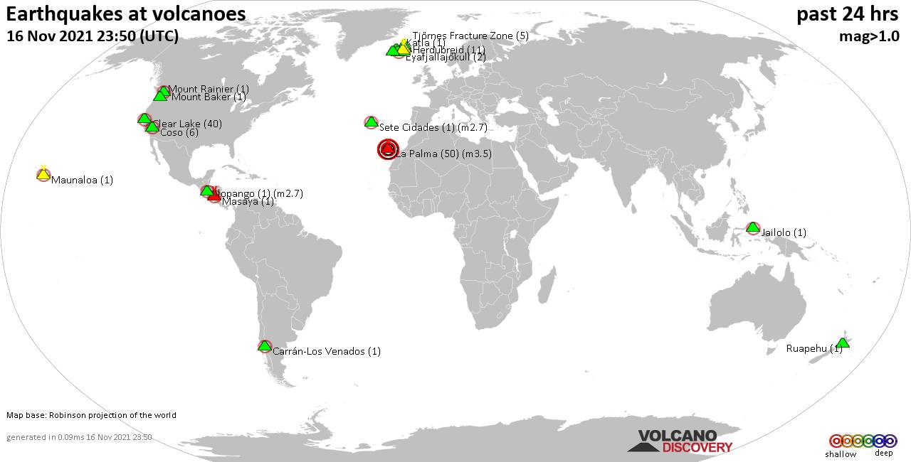
World map showing volcanoes with shallow (less than 20 km) earthquakes within 20 km radius during the past 24 hours on 17 Nov 2021 Number in brackets indicate nr of quakes.
Iliboleng (1 quake mag 2.5), Katla (1 quake mag 1.1), Kilauea (1 quake mag 1.9), Kolumbo (1 quake mag 1.6), Krísuvík (4 quakes between mag 0.5-1.5), La Palma (283 quakes between mag 2.1-3.9), Long Valley (1 quake mag 1.7), Masaraga (1 quake mag 3.0), Maunaloa (2 quakes between mag 1.9-2.0), Mount Baker (1 quake mag 1.0), Nejapa-Miraflores (1 quake mag 3.0), Ngauruhoe (1 quake mag 1.0), Nisyros (2 quakes between mag 1.8-1.8), Paricutín (Michoacán-Guanajuato) (1 quake mag 4.3), Reykjanes (7 quakes between mag 0.1-3.0), Salton Buttes (1 quake mag 1.9), Taupo (1 quake mag 1.9), Vatnafjöll (22 quakes between mag 0.3-1.9), White Island (1 quake mag 2.9) (updated 23h50)
Note: Earthquakes within 20 km from and at depths less than 20 km under active volcanoes are reported. The list is not complete because many volcanoes are not monitored and/or seismic data in high resolution is not available publicly.
Volcanoes with recent earthquakes above magnitude 2 or more than 10 quakes are listed below:
Brennisteinsfjöll volcano (Reykjanes Peninsula, Iceland): 26 earthquakes up to magnitude 2.6
Possible earthquake swarm: 26 earthquakes occurred near (under) the volcano during 16 hours, the last being recorded quake 45 minutes ago. Hypocenter depths ranged between 9.0 and 3.5 km.Earthquake details: (only 5 largest)
2.6 quake Iceland: 4.3 Km SW of Þrengsli Nov 17, 2021 9:18 pm (GMT +0) (17 km ENE)
2.4 quake Iceland: 4.6 Km SW of Þrengsli Nov 17, 2021 10:58 pm (GMT +0) (16 km ENE)
1.7 quake Iceland: 4.2 Km SW of Þrengsli Nov 17, 2021 11:01 pm (GMT +0) (17 km ENE)
1.4 quake Iceland: 4.3 Km SW of Þrengsli Nov 17, 2021 8:31 pm (GMT +0) (17 km ENE)
1.3 quake Iceland: 4.5 Km SW of Þrengsli Nov 17, 2021 4:50 pm (GMT +0) (17 km ENE)
All earthquakes at Brennisteinsfjöll
Clear Lake volcano (California): 24 earthquakes up to magnitude 2.2
Possible earthquake swarm: 24 earthquakes occurred near (under) the volcano during 22 hours, the last being recorded quake 1 hour 10 minutes ago. Hypocenter depths ranged between 11.7 and 0.6 km.Earthquake details: (only 5 largest)
2.2 quake 6km W of Cobb, CA, Nov 16, 2021 7:34 pm (GMT -8) (16 km S)
1.4 quake 7km NW of The Geysers, CA, Nov 17, 2021 3:38 am (GMT -8) (16 km S)
1.4 quake 5km WNW of Cobb, CA, Nov 16, 2021 4:46 pm (GMT -8) (15 km S)
1.3 quake 4km NNW of The Geysers, CA, Nov 17, 2021 4:38 am (GMT -8) (18 km S)
1.2 quake 6km NNW of The Geysers, CA, Nov 16, 2021 7:37 pm (GMT -8) (17 km S)
All earthquakes at Clear Lake
Herdubreid volcano (Iceland): 6 earthquakes up to magnitude 2.1
6 earthquakes occurred near (under) the volcano during 23 hours, the last being recorded quake 25 minutes ago. Hypocenter depths ranged between 8.2 and 5.0 km.Earthquake details: (only 5 largest)
2.1 quake Iceland: 3.1 Km WNW of Herðubreiðarlindir Nov 17, 2021 1:21 pm (GMT +0) (4 km NE)
1.0 quake Iceland: 3.2 Km NW of Herðubreiðarlindir Nov 17, 2021 1:21 pm (GMT +0) (4 km NE)
1.0 quake Iceland: 4.0 Km S of Herðubreið Nov 17, 2021 12:28 am (GMT +0) (4 km S)
0.8 quake Iceland: 2.9 Km S of Herðubreið Nov 17, 2021 12:19 pm (GMT +0) (4 km S)
0.6 quake Iceland: 4.4 Km N of Herðubreiðartögl Nov 17, 2021 11:24 pm (GMT +0) (6 km SSW)
All earthquakes at Herdubreid
Iliboleng volcano (Lesser Sunda Islands): magnitude 2.5 earthquake
A magnitude 2.5 earthquake occurred at the volcano 18 hours ago. The quake, which might be volcanic in origin, was located at a depth of 10.0 km depth at 13 km distance S from the volcano.Earthquake details:
2.5 quake Savu Sea, Indonesia, Nov 17, 2021 1:25 pm (GMT +8) (13 km S)
All earthquakes at Iliboleng
La Palma volcano (Canary Islands): 283 earthquakes up to magnitude 3.9
Possible earthquake swarm: 283 earthquakes occurred near (under) the volcano during 24 hours, the last being recorded quake 14 minutes ago. Hypocenter depths ranged between 16.0 and 5.0 km.Earthquake details: (only 5 largest)
3.9 quake La Palma Island, 13 km southeast of Los Llanos de Aridane, Spain, Nov 17, 2021 9:04 pm (GMT +0) (9 km S)
3.8 quake La Palma Island, 14 km southeast of Los Llanos de Aridane, Spain, Nov 17, 2021 4:10 am (GMT +0) (4 km S)
3.8 quake La Palma Island, 14 km south of Los Llanos de Aridane, Spain, Nov 17, 2021 1:42 pm (GMT +0) (8 km SW)
3.7 quake La Palma Island, 12 km southeast of Los Llanos de Aridane, Spain, Nov 17, 2021 6:34 am (GMT +0) (2 km SSW)
3.7 quake La Palma Island, 13 km southeast of Los Llanos de Aridane, Spain, Nov 17, 2021 4:26 pm (GMT +0) (3 km SSE)
All earthquakes at La Palma
Masaraga volcano (Luzon Island): magnitude 3.0 earthquake
A magnitude 3.0 earthquake occurred at the volcano 23 hours ago. The quake, which might be volcanic in origin, was located at a depth of 10.0 km depth at 11 km distance SW from the volcano.Earthquake details:
Reported seismic-like event (likely no quake): 8.3 km southeast of Polangui, Province of Albay, Bicol, Philippines, Nov 17, 2021 8:55 am (GMT +8) (11 km SW)
All earthquakes at Masaraga
Nejapa-Miraflores volcano (Nicaragua): magnitude 3.0 earthquake
A magnitude 3.0 earthquake occurred at the volcano 17 hours ago. The quake, which might be volcanic in origin, was located at a depth of 10.0 km depth at 11 km distance E from the volcano.Earthquake details:
Reported seismic-like event (likely no quake): 4.2 km southeast of Managua, Nicaragua, Nov 17, 2021 1:12 am (GMT -6) (11 km E)
All earthquakes at Nejapa-Miraflores
Paricutín (Michoacán-Guanajuato) volcano (Western & Central Mexico): magnitude 4.3 earthquake
A magnitude 4.3 earthquake occurred at the volcano 15 hours ago. The quake, which might be volcanic in origin, was located at a depth of 8.0 km depth at 9 km distance SE from the volcano.Earthquake details:
4.3 quake Nuevo Parangaricutiro, 14 km west of Uruapan, Michoacan, Mexico, Nov 17, 2021 2:38 am (GMT -6) (9 km SE)
All earthquakes at Paricutín (Michoacán-Guanajuato)
Reykjanes volcano (Reykjanes Peninsula, Iceland): 7 earthquakes up to magnitude 3.0
7 earthquakes occurred near (under) the volcano during 20 hours, the last being recorded quake 4 hours ago. Hypocenter depths ranged between 5.6 and 0.8 km.Earthquake details: (only 5 largest)
3.0 quake Iceland: 3.5 Km NE of Grindavík Nov 17, 2021 8:11 pm (GMT +0) (7 km ESE)
1.5 quake Iceland: 8.2 Km NW of Grindavík Nov 17, 2021 2:08 pm (GMT +0) (2 km W)
1.4 quake Iceland: 1.4 Km NNE of Reykjanestá Nov 17, 2021 12:34 am (GMT +0) (12 km SW)
1.3 quake Iceland: 3.3 Km NE of Grindavík Nov 17, 2021 7:54 pm (GMT +0) (7 km ESE)
1.1 quake Iceland: 3.5 Km NE of Grindavík Nov 17, 2021 4:26 am (GMT +0) (7 km ESE)
All earthquakes at Reykjanes
Vatnafjöll volcano (Iceland): 22 earthquakes up to magnitude 1.9
Possible earthquake swarm: 22 earthquakes occurred near (under) the volcano during 22 hours, the last being recorded quake 43 minutes ago. Hypocenter depths ranged between 9.4 and 5.2 km.Earthquake details: (only 5 largest)
1.9 quake Iceland: 2.7 Km SW of Vatnafjöll Nov 17, 2021 9:59 am (GMT +0) (2 km SSW)
1.9 quake Iceland: 2.4 Km SW of Vatnafjöll Nov 17, 2021 9:01 am (GMT +0) (2 km SSW)
1.6 quake Iceland: 0.5 Km SW of Vatnafjöll Nov 17, 2021 1:35 pm (GMT +0) (1 km ESE)
1.4 quake Iceland: 0.5 Km NNE of Vatnafjöll Nov 17, 2021 1:38 am (GMT +0) (1 km ENE)
1.3 quake Iceland: 1.1 Km SSW of Vatnafjöll Nov 17, 2021 1:11 am (GMT +0) (1 km SSE)
All earthquakes at Vatnafjöll
White Island volcano (New Zealand): magnitude 2.9 earthquake
A magnitude 2.9 earthquake occurred at the volcano 9 hours ago. The quake, which might be volcanic in origin, was located at a depth of 5.0 km depth at 17 km distance SSW from the volcano.Earthquake details:
2.9 quake South Pacific Ocean, 35 km north of Whakatane, Bay of Plenty, New Zealand, Nov 18, 2021 4:03 am (GMT +13) (17 km SSW)
All earthquakes at White Island
Previous news
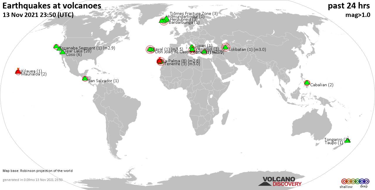
Tue, 16 Nov 2021, 23:50
Volcano earthquake report for Tuesday, 16 Nov 2021
Quakes detected near: Askja (4 quakes between mag 0.3-1.1), Carrán-Los Venados (1 quake mag 2.5), Clear Lake (40 quakes between mag 0.3-2.0), Coso (6 quakes between mag 0.4-2.1), Eyafjallajökull (2 quakes between mag 1.1-2.1), Grímsvötn (1 quake mag 1.1) ... Read all
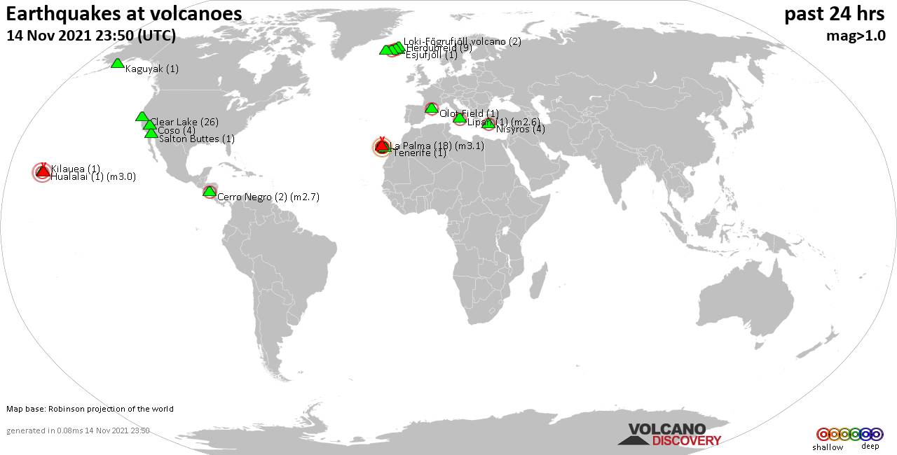
Mon, 15 Nov 2021, 23:50
Volcano earthquake report for Monday, 15 Nov 2021
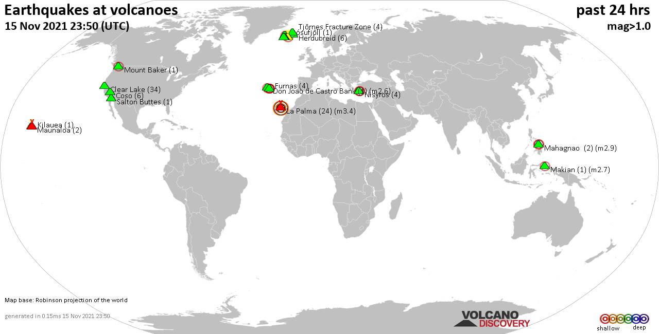
Quakes detected near: Brennisteinsfjöll (1 quake mag 1.2), Clear Lake (34 quakes between mag 0.2-1.9), Coso (6 quakes between mag 0.3-1.9), Don Joao de Castro Bank (1 quake mag 2.6), Furnas (4 quakes between mag 2.0-2.4), Hekla (7 quakes between mag 0.5-2.2) ... Read all
Show more